
Suffield is a town in Hartford County, Connecticut, United States. The town is part of the Capitol Planning Region, and located in the Connecticut River Valley. As of the 2020 census, the population was 15,752. The town center is a census-designated place listed as Suffield Depot.

Courtland is an incorporated town in Southampton County, Virginia, United States. It is the county seat of Southampton County.

The Bethania Historic District encompasses the historic planned center of the town of Bethania, North Carolina. A National Historic Landmark District, it is a rare example of a Moravian linear agricultural village in the United States, planned and founded in 1759. Land use and road patterns of the original plan are still discernible in the community. It was declared a National Historic Landmark in 2001, and is at 500 acres (2.0 km2) the largest historic district in Forsyth County.

The Memorial Drive Apartments Historic District is a historic district encompassing four apartment houses on Memorial Drive in Cambridge, Massachusetts. They are located between the Anderson Memorial Bridge and the Eliot Bridge with street numbers ranging from 983 to 993 Memorial Drive. All four buildings were built between 1916 and 1924, not long after Memorial Drive had been laid out, and were, despite significant similarities of style, designed by three different architects. All provide good views of the Charles River. The district was listed on the National Register of Historic Places in 1986.

The Five Corners Historic District is a historic district encompassing the central district of the village of South Williamstown, Massachusetts. It is centered at the junction of Cold Spring, Green River, New Ashford. The junction has been a prominent center in the area since 1760. Prominent buildings in the district include the South Center School, the Store at Five Corners, and the Second Congregational Church. The district was listed on the National Register of Historic Places in 1993.
The Northfield Main Street Historic District is a historic district located along the full length of Main Street from Millers Brook to Pauchaug Brook in Northfield, Massachusetts. The district encompasses the part of Main Street that was laid out when Northfield was first established in the 17th century. The area has retained many of its traditional lot divisions, and features civic and residential construction from the 18th to the 20th centuries. The district was listed on the National Register of Historic Places in 1982.

The Hadley Center Historic District is an expansive, 2,500-acre (1,000 ha) historic district encompassing the village center of Hadley, Massachusetts. When it was first listed on the National Register of Historic Places in 1977, the district encompassed the town green and 17 buildings that faced it, at the junction of Russell Street and Middle Street. The district was expanded significantly in 1994, adding more than 400 buildings representative of the village's growth from colonial days into the first decades of the 20th century. This expansion encompasses the entirety of a tongue of land extending west from East Street and bounded by a bend in the Connecticut River, which separates Hadley from Northampton. Its oldest property, the Samuel Porter House on West Street, was built in 1713.

The Hatfield Center Historic District encompasses the traditional center of Hatfield, Massachusetts. The area, first laid out in 1661, is bounded by Maple Street to the south, the Connecticut River to the east, Day Avenue and School Street to the north, and the Mill River to the west. The area's layout and land use patterns are relatively little altered since they were laid out, leaving a well-preserved early colonial village landscape. The district was added to the National Register of Historic Places in 1994.

The Parsons, Shepherd, and Damon Houses Historic District is a historic district on the east side of downtown Northampton, Massachusetts encompassing a 2.5-acre (1.0 ha) property that was first laid out in 1654. Now owned by Historic Northampton, the property includes three houses built between 1730 and 1830. The district was added to the National Register of Historic Places in 2001.

The Upper Main Street Historic District is a predominantly residential historic district in northeastern Hatfield, Massachusetts. Unlike Hatfield Center, which dated to colonial days and lies south of the district, this part of Hatfield developed roughly between 1860 and 1939 as a village centered on the nearby ferry landing on the Connecticut River. The district includes properties in a roughly triangular area bounded by Main Street, King Street, and North Street, and features a large number of Colonial Revival, Queen Anne, and bungalow-style houses. The district was listed on the National Register of Historic Places in 1994.
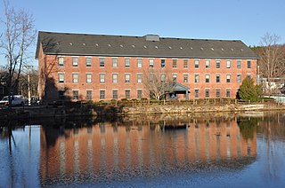
The Ballardvale District in Andover, Massachusetts, encompasses the historic mill village of Ballardvale in the northwestern part of the town. It is centered on the crossing the Shawsheen River by Andover Street, and includes buildings on High Street, Center Street, and other adjacent roads on both sides of the river. The district was listed on the National Register of Historic Places in 1982.

The John Eliot Historic District encompasses what was the historic early village center of Natick, Massachusetts. Now the heart of the village of South Natick, it now exhibits a diversity of architecture from the 18th to early 20th centuries, laid out along historic 17th-century colonial routes. It was listed on the National Register of Historic Places in 1983.

Wakefield Park Historic District is a residential historic district encompassing a portion of a late-19th/early-20th century planned development in western Wakefield, Massachusetts. The district encompasses sixteen properties on 8 acres (3.2 ha) of land out of the approximately 100 acres (40 ha) that comprised the original development. Most of the properties in the district are on Park Avenue, with a few located on immediately adjacent streets.

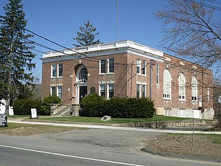
The Canton Corner Historic District is a historic district encompassing the historic town center of Canton, Massachusetts. Centered on the junction of Pleasant and Washington Streets, it includes more than 25 properties and 170 acres (69 ha), whose architectural history spans 250 years of occupation and include the town's major civic buildings. The district was added to the National Register of Historic Places on September 9, 2009.

The Anacostia Historic District is a historic district in the city of Washington, D.C., comprising approximately 20 squares and about 550 buildings built between 1854 and 1930. The Anacostia Historic District was added to the National Register of Historic Places in 1978. "The architectural character of the Anacostia area is unique in Washington. Nowhere else in the District of Columbia does there exist such a collection of late-19th and early-20th century small-scale frame and brick working-class housing."

North Leverett is a historic mill village of Leverett, Massachusetts. Centered on the intersection of North Leverett Road with Chestnut Hill Road and Cave Hill Road it includes predominantly residential buildings that were built during the height of the area's industrial activity between the 1770s and mid-19th century. The architecture is mainly Federal and Greek Revival in style, including the 1832 North Leverett Baptist Church. The Slarrow Mill is the only remaining component of the village's industrial past. The village was listed as a historic district on the National Register of Historic Places in 2014.

The East Leverett Historic District of Leverett, Massachusetts, encompasses the historic mill village of East Leverett. Centered on the intersection of Cushman Road and Shutesbury Road in the southeastern portion of the rural town, it includes predominantly residential buildings that were built during the height of the area's industrial activity in the first four decades of the 19th century. The architecture is mainly Federal and Greek Revival in style. The district was listed on the National Register of Historic Places in 2014.

Upton State Forest is a publicly owned forest with recreational features primarily located in the town of Upton, Massachusetts, with smaller sections in the towns of Hopkinton and Westborough. The state forest encompasses nearly 2,800 acres (1,100 ha) of publicly accessible lands and includes the last remaining Civilian Conservation Corps (CCC) camp in Massachusetts, built in Rustic style. The CCC campground was listed on the National Register of Historic Places in 2014.
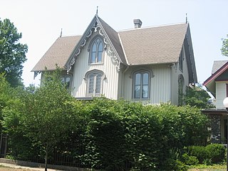
The Horatio Chapin House, or simply, the Chapin House, is a historic home located at South Bend, St. Joseph County, Indiana. It was built between 1855 and 1857 by Horatio Chapin, one of the early settlers of South Bend and the first president of the board of town trustees. The house consists of a 2+1⁄2-story, cross-plan, Gothic Revival style frame dwelling, a rare example of its kind in the region. It's considered an outstanding example of Gothic Revival architecture influenced by architect Andrew Jackson Downing. It is sheathed in board and batten siding and features lancet windows and a steeply pitched cross-gable roof with an elaborately carved bargeboard. The Chapin House is widely recognized as one of the most significant homes in the state of Indiana, and in 1980 it was listed on the National Register of Historic Places.

The Middle Cemetery is an historic cemetery on Main Street in southern Lancaster, Massachusetts. Established in 1798, it is the town's third oldest cemetery, with active burials taking place until 1969. The cemetery was listed on the National Register of Historic Places in 2019.


