
The East Blackstone Village Historic District is a historic district roughly along Elm Street at the junction with Summer Street in eastern Blackstone, Massachusetts. It encompasses a small 19th-century mill village center that developed along what was once a major roadway connecting Worcester with Providence, Rhode Island. The district was added to the National Register of Historic Places in 1995.

The Russells Mills Village Historic District is a historic district on Russells Mills, Rock O' Dundee, Slades Corner, Horseneck and Fisher Roads in Dartmouth, Massachusetts. It encompasses an area that was an early industrial center, flourishing from the 18th century into the early 19th century. The district was added to the National Register of Historic Places in 1985.

The South Lee Historic District encompasses the historic portion of the village of South Lee in Lee, Massachusetts. Extending mainly along Massachusetts Route 102 between Fairview Street and the Stockbridge town line, the village is a well-preserved 19th-century mill village, with fine Federal and Greek Revival buildings and a later 19th-century paper mill. It was listed on the National Register of Historic Places in 1999.

The Cushman Village Historic District is a historic district encompassing a portion of the Cushman Village area of Amherst, Massachusetts, which was a significant mill village during the 19th century. It is centered on the triangle formed by Bridge, Henry, and Pine Streets in northeastern Amherst, and arose because of the presence of falls on the Mill River, whose water power was harnessed for mills as early as the mid-18th century. Two houses survive from the colonial period. The village, although it was defined for many years by the mills, no longer has any industrial buildings, as they were demolished or destroyed by fire. Most of the houses in the district were built before 1860, the peak of the village's industrial activity. The district was listed on the National Register of Historic Places in 1992.

The South Worthington Historic District is a historic district encompassing the formerly industrial, but now rural, village of South Worthington, Massachusetts. The village is centered on the junction of Huntington Road, Ireland Street, and Thrasher Hill Road. The district extends along Ireland Road as far as Conwell Road, and one contributing element, the dam which impounds Little Galilee Pond, extends into neighboring Chesterfield. The area had a number of small mills along the banks of the Little River, a tributary of the Westfield River, but only one complex, the Theron Higgins Mill on South Worthington Road, has survived from the 19th century. Most of the buildings in the district are residences dating to the 19th century; also included are three churches, including the particularly elegant Greek Revival South Worthington Methodist Church (1848). The district was added to the National Register of Historic Places in 2005.

The Huntington Village Historic District encompasses the historic village center of Huntington, Massachusetts, USA. The village lies on the west branch of the Westfield River, at the junction of US Route 20 and Massachusetts Route 112. The district was listed on the National Register of Historic Places in 1999. The village is the most densely populated part of Huntington, and has been its commercial and civic heart since the early 19th century. It has been divided by the river because its unifying feature, a location where bridges stood since 1810, no longer has one, and the modern replacement bridge built after a 1938 flood just south of the center, does not readily combine the developed areas on either side.

The Mill–Prospect Street Historic District in Hatfield, Massachusetts encompasses a historic landscape with over 300 years of industrial and agricultural history. It was listed on the National Register of Historic Places in 2002. The district runs along Prospect Street, a north-south road that roughly bisects Hatfield, from its southern end at Elm Street to a point north of its junction with Chestnut Street, and includes properties on adjacent roadways. The central focus of the district is the Mill River which meanders from west to east across the district's middle. At the Prospect Street crossing is a cluster of former late 19th century industrial buildings, some of which comprise the Old Mill Site Historic District, listed in 1982.
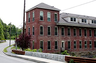
The Brookside Historic District of Westford, Massachusetts encompasses surviving elements of the 19th century Brookside mill village, the smallest of the town's three 19th-century industrial villages. Developed between about 1860 and 1904, it includes surviving mill buildings and a variety of mill-related worker housing. The district was listed on the National Register of Historic Places in 2003.
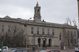
The Arlington Center Historic District includes the civic and commercial heart of Arlington, Massachusetts. It runs along the town's main commercial district, Massachusetts Avenue, from Jason Street to Franklin Street, and includes adjacent 19th- and early 20th-century residential areas roughly bounded by Jason Street, Pleasant Street, and Gray Street. The district was listed on the National Register of Historic Places in 1974.

The Indian Brook Road Historic District is located on both sides of that street's intersection with US 9 east of Garrison, New York, United States. Its 30 acres (12 ha) contain 15 buildings, all but two of which are considered contributing properties to its historic character.

North Leverett is a historic mill village of Leverett, Massachusetts. Centered on the intersection of North Leverett Road with Chestnut Hill Road and Cave Hill Road it includes predominantly residential buildings that were built during the height of the area's industrial activity between the 1770s and mid-19th century. The architecture is mainly Federal and Greek Revival in style, including the 1832 North Leverett Baptist Church. The Slarrow Mill is the only remaining component of the village's industrial past. The village was listed as a historic district on the National Register of Historic Places in 2014.

The Leverett Center Historic District is an expansive 467-acre (189 ha) historic district encompassing the historic heart of the rural community of Leverett in eastern Franklin County, Massachusetts. The district is focused on a two-mile stretch of Depot and Montague Roads, at whose center is the civic heart of the town. It includes the 1838 Greek Revival First Congregational Church, the town hall, whose present form was achieved in 1895 by raising the 1845 construction and building a first floor underneath it, and the Colonial Revival Field Memorial Library (1916). It also includes a town pound built c. 1822, and a number of 18th century residences. The district was listed on the National Register of Historic Places in 2008.

The West Chesterfield Historic District is a historic district that encompasses the 19th century industrial and residential heritage of the village of West Chesterfield in the town of Chesterfield, Massachusetts. Centered at the junction of Main Road and Ireland Street, it was one of the town's main industrial sites for many years. The district was listed on the National Register of Historic Places in 2008.

The Head of the River Historic District is a historic district encompassing a village area at the head of navigation of the Acushnet River, which separates Acushnet and New Bedford, Massachusetts. The village is centered at the junction of Tarkin Hill Road, River Road, and Mill Road in New Bedford, and Main Street in Acushnet. The area went through two significant periods of development: the first was in the late 18th and early 19th century, and the second was in the early 20th century. The district was listed on the National Register of Historic Places in 2009.

The Moore's Corner Historic District of Leverett, Massachusetts, encompasses the historic rural mill village of Moore's Corner. Centered on the intersection of North Leverett Road with Dudleyville Road, Church Hill Road, and Rattlesnake Gutter Road, it includes 15 houses and several other buildings, mainly from the village's mid-19th century peak as a modest rural village center. The district was listed on the National Register of Historic Places in 2014.

The Brattleboro Downtown Historic District encompasses most of the central business district of the town of Brattleboro, Vermont. Extending along Main Street between Whetstone Brook and a junction with Pultney Road and Linden and Walnut Streets, this area includes many of the town's prominent civic and institutional buildings. The area's development took place primarily in the 19th century, with surviving buildings from both the 18th and early 20th centuries. The district was listed on the National Register of Historic Places in 1983, and was enlarged in 2004 to include Plaza Park and the Holstein Building on the south side of Whetstone Brook.

The Grafton Village Historic District encompasses the historic village center of the town of Grafton, Vermont. The village was developed in the early-to-mid 19th century, and has retained the character of that period better than many small communities in the state. The district was listed on the National Register of Historic Places in 2010.

The East Arlington Village Historic District encompasses the historic core of a 19th-century village in Arlington and Sunderland, Vermont, USA. It is centered on Old Mill Road, and developed as a mill village beginning in the 18th century. It was listed on the National Register of Historic Places in 1996.

The Standish Corner Historic District encompasses a collection of five early farmhouses in the village of Standish Corner in southeastern Standish, Maine. All five houses were built in the late 18th or early 19th century, and the assemblage are all that survive of the town's original early center. The district was listed on the National Register of Historic Places in 1993.

The Warren Village Historic District encompasses the village center of Warren, Vermont. Stretched mainly along Main Street east of the Mad River, it is a well-preserved 19th-century mill village, although most of its period mill infrastructure has been lost. The district has good examples of Greek Revival, Italianate, and Second Empire architecture. It was listed on the National Register of Historic Places in 1992.


