
The Ashburnham Center Historic District is a historic district encompassing the core of the village center of Ashburnham, Massachusetts in the United States. It is a well-preserved industrial village that experienced its most significant period of growth in the mid-19th century. The district was added to the National Register of Historic Places in 1999.
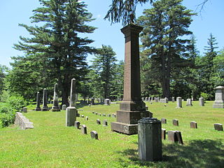
Brookfield Cemetery is an historic cemetery on Main Street on the west side of Brookfield, Massachusetts. Established in 1714, it is the town's only cemetery. It consequently holds the burials of many of Brookfield's founders and leading citizens, from the 18th century to the present, including those of neighboring towns that were once a part of Brookfield. The 43-acre (17 ha) cemetery has about 10,000 marked graves. It was listed on the National Register of Historic Places in 2003.
The South Coventry Historic District is a historic district encompassing the historic village center of South Coventry in the town of Coventry, Connecticut. The village, settled in the early 18th century, has served as Coventry's civic center, and also served as an economic center, with textile mills operating in the 19th century. The district was listed on the National Register of Historic Places in 1991.

The Harvard Center Historic District is a historic district encompassing the traditional village center of Harvard, Massachusetts, USA. The district is centered on the town common, a triangular grassy space bounded by Elm Street, Still River Road, and Ayer Road. The common is ringed by residences, civic and religious buildings, and a small commercial area. The common was laid out when the town was founded in 1732, and has grown, mainly in periods of growth at the late 18th and late 19th/early 20th centuries. Most of the village's buildings post-date 1831. The district was added to the National Register of Historic Places in 1997.

The Northside Historic District encompasses two of the earliest significant settlement areas of Yarmouth, Massachusetts. Stretching along Massachusetts Route 6A from the Barnstable line in the west to White Brook in the east, the district includes almost 300 buildings on 50 acres (20 ha). It includes the two villages of Yarmouth Center and Yarmouthport, which were important 18th and 19th century centers of civic and economic activity.

The Old King's Highway Historic District encompasses what was historically the principal east–west thoroughfare through Barnstable, Massachusetts. It encompasses Barnstable's entire length of what is now designated Massachusetts Route 6A and called Main Street, between the town lines of Sandwich and Yarmouth. It includes more than 1,000 acres (400 ha), and includes all of the buildings whose properties front on the road, nearly 500 in all. The area includes the main population centers of Barnstable from its founding in the late 1630s until the mid-19th century, when the southern parts of the community became more significant in economic prominence. The district was listed on the National Register of Historic Places in 1987.

The South Yarmouth/Bass River Historic District is a historic district in the southeastern part of Yarmouth, Massachusetts. It encompasses a predominantly residential area centered on a portion of Old Main Street and South Street between the villages of South Yarmouth and Bass River. The area's history is one of maritime-related industry from the late 18th to late 19th century, and then its growth as a tourist resort community. The district was listed on the National Register of Historic Places in 1990.

The Charlemont Village Historic District is a historic district on Massachusetts Route 2 between South Street and Harmony Lane, encompassing much of the village center of Charlemont, Massachusetts, United States. The district's properties represent the growth of the village center from its rural origin through a period of 19th century industrialization, including 18th and 19th century farmsteads, Greek Revival buildings of the mid 19th century, and later 19th century Victorian architectural styles. The district was added to the National Register of Historic Places in 1988.

The Main Street Historic District encompasses the civic core of Greenfield, Massachusetts, the county seat of Franklin County, Massachusetts. The district includes several blocks of Main Street extending roughly from Chapman Street in the west to Franklin Street in the east, as well as a number of properties facing the common along Bank Row, south of Main Street, and is architecture reflective of the city's 19th-century growth as a major crossroads and county seat. The district includes the town hall, county courthouse, several 19th century bank buildings, and three properties previously listed on the National Register of Historic Places: the Garden Theater Block, the Leavitt-Hovey House, and the 1915 Post Office building. The district was listed on the National Register of Historic Places in 1988.

The New Salem Common Historic District encompasses the historic town center of New Salem, Massachusetts. Located on South Main Street, it includes the town common and most of its civic and institutional buildings. Most buildings in the district date to the 18th and 19th centuries. The district was listed on the National Register of Historic Places in 1978.

The Hatfield Center Historic District encompasses the traditional center of Hatfield, Massachusetts. The area, first laid out in 1661, is bounded by Maple Street to the south, the Connecticut River to the east, Day Avenue and School Street to the north, and the Mill River to the west. The area's layout and land use patterns are relatively little altered since they were laid out, leaving a well-preserved early colonial village landscape. The district was added to the National Register of Historic Places in 1994.

The Main Street Historic District of Easthampton, Massachusetts encompasses the historic heart of the town, running along Main Street between Northampton and Center Streets. The area has been the civic and economic heart of the town since incorporation in 1785. Most of the commercial buildings date from the 1840s to the 1880s, and are built in an Italianate style. The housing stock of the district also includes Italianate styling, but there are also a number of Greek Revival structures. The major civic structures of the town are in the district, including the town hall, public library, and the First Congregational Church, which is the second for the congregation, a brick Romanesque Revival building dating to 1851. The district was added to the National Register of Historic Places in 1986.

The Norwich Village Historic District encompasses the compact village center of Norwich, Vermont. The village was developed mainly in the first half of the 19th century, benefiting in importance from the 1820 founding of what is now Norwich University. The district has well-preserved examples of architecture ranging from the late 18th century to the early 20th century. It was listed on the National Register of Historic Places in 1991.

The Hollis Village Historic District encompasses the historic village center of Hollis, New Hampshire. The district is centered on Monument Square, which connects Main Street to Depot Street and Broad Street. It covers about 400 acres (160 ha), and extends along all three of those roads for some distance, and includes properties on Silver Lake Road and Ash Street. Most of the buildings in the district are residential or agricultural in use, and date before the turn of the 20th century; the oldest buildings date to the mid-18th century. The "Always Ready Engine House", which occupies a triangular parcel at the western end of Monument Square, was built in 1859, and is the town's oldest municipal building. Its most architecturally sophisticated building is the town hall, built in 1887 to a design by William M. Butterfield of Manchester. The district represents the growth of a mainly agricultural community over a 200-year period. The district was listed on the National Register of Historic Places in 2001.
The New Ipswich Center Village Historic District encompasses the historic center of the rural town of New Ipswich, New Hampshire. The center village is the town's most densely populated area, with a history dating to the town's founding in 1735. The district extends along Turnpike Road between King and Porter Roads, and southward in a roughly triangular shape, the southern point of which is at the junction of Main Street and Willard Road. The village includes a large number of residences, which were mainly agricultural at first, but also include a number of properties built as summer resort houses in the late 19th and early 20th centuries. It also includes most of the town's historic civic buildings, including its historic town hall, and the Barrett House, now a museum property owned by Historic New England. The district was listed on the National Register of Historic Places in 1991.

The Town Center Historic District encompasses the historic village center of South Hampton, New Hampshire. Centered around the Barnard Green, the town common, on New Hampshire Route 107A, it includes architectural reminders of the town's growth and change over time. The district was listed on the National Register of Historic Places in 1983.

The Putney Village Historic District encompasses most of the main village and town center of Putney, Vermont. Settled in the 1760s, the village saw its major growth in the late 18th and early 19th century, and includes a cohesive collection with Federal and Greek Revival buildings, with a more modest number of important later additions, including the Italianate town hall. The district was listed on the National Register of Historic Places in 1986.

The Randolph Center Historic District encompasses the historic early town center of Randolph, Vermont. Established in 1783, it was later eclipsed by Randolph Village, which developed around the town's main railroad depot. The village now has a distinguished array of late 18th and early 19th-century architecture, and is home to an academic campus now housing Vermont State University. It was listed on the National Register of Historic Places in 1974.

The Montgomery House is a historic travel accommodation on Vermont Route 118 in the center of Montgomery, Vermont. Built in 1803, it is one of the town's oldest buildings, and it served for many years as a social and civic center in the small community. It was listed on the National Register of Historic Places in 1992.
The South Chatham Village Historic District is a historic district encompassing much of the linear village of South Chatham in Chatham, Massachusetts. Extending eastward from the Harwich town line along Main Street, the district developed in the 18th and 19th centuries as a maritime and farming village. The district was listed on the National Register of Historic Places in 2022.


