
The East Blackstone Village Historic District is a historic district roughly along Elm Street at the junction with Summer Street in eastern Blackstone, Massachusetts. It encompasses a small 19th-century mill village center that developed along what was once a major roadway connecting Worcester with Providence, Rhode Island. The district was added to the National Register of Historic Places in 1995.

The Harvard Center Historic District is a historic district encompassing the traditional village center of Harvard, Massachusetts, USA. The district is centered on the town common, a triangular grassy space bounded by Elm Street, Still River Road, and Ayer Road. The common is ringed by residences, civic and religious buildings, and a small commercial area. The common was laid out when the town was founded in 1732, and has grown, mainly in periods of growth at the late 18th and late 19th/early 20th centuries. Most of the village's buildings post-date 1831. The district was added to the National Register of Historic Places in 1997.

The Five Corners Historic District is a historic district encompassing the central district of the village of South Williamstown, Massachusetts. It is centered at the junction of Cold Spring, Green River, New Ashford. The junction has been a prominent center in the area since 1760. Prominent buildings in the district include the South Center School, the Store at Five Corners, and the Second Congregational Church. The district was listed on the National Register of Historic Places in 1993.

The Ashfield Plain Historic District is a historic district roughly, along Main and South Streets and adjacent parts of Buckland and Norton Hill Roads in Ashfield, Massachusetts. It encompasses the village center of the town, which has acted as a civic and commercial center since the late 18th century. Its architectural heritage dates back to that time, but is now dominated by buildings from the late 19th and early 20th centuries. The district was listed on the National Register of Historic Places in 1991.

The Burkeville Covered Bridge is a historic covered bridge, carrying Main Poland Road over the South River in Conway, Massachusetts. Probably built in 1870, it is a regionally rare example of a multiple kingrod bridge with iron tensioning verticals, and one of a few 19th century covered bridges to survive in Massachusetts. It was listed on the National Register of Historic Places in 1988.

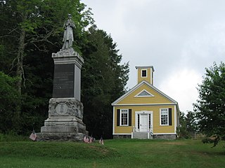
The Heath Center Historic District encompasses a rural village with predominantly 18th- and 19th-century structures in Heath, a small agricultural town in hills of northwestern Franklin County, Massachusetts, United States. The district is centered on the junction of several roads, around which the center of the town grew. South Road arrives from the south, East Main Street and Bray Road from the east, Ledge Road from the north, and West Main Street from the west.

The Williamsburg Center Historic District is a historic district on Massachusetts Route 9 in Williamsburg, Massachusetts. It encompasses the traditional center of the town, which was settled in the 18th century and grew to prosperity in the mid-19th century. It was listed on the National Register of Historic Places in 1980.

The Huntington Village Historic District encompasses the historic village center of Huntington, Massachusetts, USA. The village lies on the west branch of the Westfield River, at the junction of US Route 20 and Massachusetts Route 112. The district was listed on the National Register of Historic Places in 1999. The village is the most densely populated part of Huntington, and has been its commercial and civic heart since the early 19th century. It has been divided by the river because its unifying feature, a location where bridges stood since 1810, no longer has one, and the modern replacement bridge built after a 1938 flood just south of the center, does not readily combine the developed areas on either side.

The East End Historic District encompasses the historic eastern portion of central Ipswich, Massachusetts. The now predominantly residential district is bounded on the north and west by East Street, running from its junction with North Main and High Streets to Jeffrey's Neck Road. The eastern boundary includes the Ipswich River and Turkey Shore Road from its junction with Labor-in-Vain Road to Green Street, and the southern boundary runs along Green Street to North Main. The district was listed on the National Register of Historic Places in 1980.

The Taftsville Historic District encompasses a historic 19th-century industrial village that is mostly in Woodstock, Vermont. Flanking the Ottauquechee River and extending up Happy Valley Road, the area developed around a metal tool factory established by members of the Taft family in 1793. Important elements from its early history include the Taftsville Store, built by the Taft family in 1840, and the Taftsville Covered Bridge, built in 1836. The district was listed on the National Register of Historic Places in 2001.

The East Jaffrey Historic District is a historic district running roughly along NH Route 124 through Jaffrey, New Hampshire. It encompasses what is now the economic and civic heart of the town, centered on the Jaffrey Mills and the crossing of the Contoocook River by Route 124. It extends as far west as St. Patrick's Church beyond Charlonne Street and as far east as the US Post Office building at Route 124 and Ellison Street. To the north it extends along Peterborough Street to Christian Court, and to the south it extends along River Street and School Street to their junction. The district includes early 19th-century residential structures, as well as industrial buildings and housing associated with the Jaffrey Mills which arose in the mid-19th century. The district was added to the National Register of Historic Places in 2002.

The West Chesterfield Historic District is a historic district that encompasses the 19th century industrial and residential heritage of the village of West Chesterfield in the town of Chesterfield, Massachusetts. Centered at the junction of Main Road and Ireland Street, it was one of the town's main industrial sites for many years. The district was listed on the National Register of Historic Places in 2008.

The Head of the River Historic District is a historic district encompassing a village area at the head of navigation of the Acushnet River, which separates Acushnet and New Bedford, Massachusetts. The village is centered at the junction of Tarkiln Hill Road, River Road, and Mill Road in New Bedford, and Main Street in Acushnet. The area went through two significant periods of development: the first was in the late 18th and early 19th century, and the second was in the early 20th century. The district was listed on the National Register of Historic Places in 2009.

The Charlestown Main Street Historic District encompasses the historic heart of Charlestown, New Hampshire. It is located along Main Street, roughly between Lower Landing Road and Bridge Street, and encapsulates more than two hundred years of the town's history. The district was listed on the National Register of Historic Places in 1987.

The Jewell Town District of South Hampton, New Hampshire, encompasses a colonial-era industrial village with a history dating to 1687. It is centered at the junction of West Whitehall and Jewell Streets, which is just south of a bend in the Powwow River, the source of the power for the mills that were built here. The area was settled in 1687 by Thomas Jewell, and by the early 19th century included a variety of mills as well as a bog iron works. The district now includes only remnants of its industrial past, and features a collection of 18th and early-19th century residential architecture. The district was listed on the National Register of Historic Places in 1983.

The Town Center Historic District encompasses the historic village center of South Hampton, New Hampshire. Centered around the Barnard Green, the town common, on New Hampshire Route 107A, it includes architectural reminders of the town's growth and change over time. The district was listed on the National Register of Historic Places in 1983.
The Dennysville Historic District encompasses the historic town center of Dennysville, Maine. Located near the southern end of the large rural community, its architecture covers more than 100 years of community history, from the early 19th to early 20th centuries. The district extends along Main Street between Maine State Route 86 and Bunker Hill Road, on the west bank of the Dennys River. It was listed on the National Register of Historic Places in 1982.

The Watertown Center Historic District encompasses the historic village center of Watertown, Connecticut. It exhibits architectural and historic changes from the early 1700s into the 20th century. It is roughly bounded by Main, Warren, North, Woodbury, Woodruff, and Academy Hill Roads, and was listed on the National Register of Historic Places in 2001.

The Manchaug Village Historic District is a historic district encompassing the 19th century industrial village center of Manchaug in Sutton, Massachusetts. Developed in the 1820s around textile mills on the Mumford River, it was the largest industrial area in Sutton, with at least three mill complexes in operation. The district is centered on the junction of Main Street with Manchaug, Putnam Hill, and Whitins Roads.

The Cove Street Historic District encompasses a small 19th-century neighborhood area of Duxbury, Massachusetts. Located along Cove Street north of the town center, it was developed in the early 19th century to provide housing for workers in nearby shipyards. The architecture of the district includes a variety of single-family housing styles common to the region and time period. The district was added to the National Register of Historic Places in 2019.


