
The Old Douglas Center Historic District encompasses the historic heart of Douglas, Massachusetts. The historic district radiates away from the town common, and is bounded by farmlands and more recent 20th-century development. There are 50 contributing resources in the 192-acre (78 ha) district. Most of the structures are residential houses in Federal and Greek Revival styles. There are a number of institutional buildings, including the 1834 Greek Revival First Congregational Church, the Craftsman-style Douglas Pastime Club building at 22 Church Street, and the c. 1770s Dudley Tavern. The town common and the adjacent Center Cemetery, laid out when the town was incorporated in 1746, are at the center of the district.

The Barre Common District is a historic district encompassing the town common of Barre, Massachusetts, and immediately adjacent historic buildings. It is bounded roughly by South, Exchange, Main, Pleasant, Broad, School and Grove Streets. The Barre common was laid out in 1792, and has been a focus of the town's civic life ever since, and is flanked by a number of high-quality Greek Revival buildings, as well as those in other styles. The district was listed on the National Register of Historic Places in 1976.

Westminster Village–Academy Hill Historic District encompasses the historic first town center of Westminster, Massachusetts, as well as its later early-19th century commercial core. Centered at the junction Main and South Streets with Academy Hill Road, it contains fine examples of Colonial, Federal, and Greek Revival architecture, including the 1839 town hall. The district was listed on the National Register of Historic Places in 1983.

The Harvard Center Historic District is a historic district encompassing the traditional village center of Harvard, Massachusetts, USA. The district is centered on the town common, a triangular grassy space bounded by Elm Street, Still River Road, and Ayer Road. The common is ringed by residences, civic and religious buildings, and a small commercial area. The common was laid out when the town was founded in 1732, and has grown, mainly in periods of growth at the late 18th and late 19th/early 20th centuries. Most of the village's buildings post-date 1831. The district was added to the National Register of Historic Places in 1997.

The Sheffield Plain Historic District encompasses the original 18th-century village center of Sheffield, Massachusetts, United States. The linear district extends southward about 0.5 miles (0.80 km) from the junction of United States Route 7 and Cook Road, where the original town common is located. The district was primarily developed in the mid-18th and early 19th centuries. It was listed on the National Register of Historic Places in 1988.

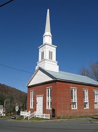
The Bernardston Congregational Unitarian Church is a historic church building at 49 Church Street in Bernardston, Massachusetts. The church is notable for the history of construction, movement, and reconstruction, since it was first erected in 1739, just two years after Bernardston was settled. It was added to the National Register of Historic Places in 1993. Its congregation is affiliated with the Unitarian Universalist Association which was established in 1820.

The Charlemont Village Historic District is a historic district on Massachusetts Route 2 between South Street and Harmony Lane, encompassing much of the village center of Charlemont, Massachusetts, United States. The district's properties represent the growth of the village center from its rural origin through a period of 19th century industrialization, including 18th and 19th century farmsteads, Greek Revival buildings of the mid 19th century, and later 19th century Victorian architectural styles. The district was added to the National Register of Historic Places in 1988.
The Colrain Center Historic District encompasses the historic center of Colrain, Massachusetts, a rural hill town in north-western Franklin County. The 30-acre (12 ha) district was listed on the National Register of Historic Places in 2006.

The Heath Center Historic District encompasses a rural village with predominantly 18th- and 19th-century structures in Heath, a small agricultural town in hills of northwestern Franklin County, Massachusetts, United States. The district is centered on the junction of several roads, around which the center of the town grew. South Road arrives from the south, East Main Street and Bray Road from the east, Ledge Road from the north, and West Main Street from the west.

The Bradstreet Historic District encompasses the rural 19th-century village of Bradstreet in Hatfield, Massachusetts. It is centered at the junction of Depot Road and Main Street, and includes properties lining those two streets and Old Farm Road. Most of the buildings in the area date to the second half of the 19th century, featuring architectural styles typical of the period, including Queen Anne, Second Empire, Italianate, and Colonial Revival. The village grew on land that was originally granted to colonial governor Simon Bradstreet and divided in 1682, and has remained largely agricultural since then. The district was listed on the National Register of Historic Places in 1997.
The Arlington Center Historic District includes the civic and commercial heart of Arlington, Massachusetts. It runs along the town's main commercial district, Massachusetts Avenue, from Jason Street to Franklin Street, and includes adjacent 19th- and early 20th-century residential areas roughly bounded by Jason Street, Pleasant Street, and Gray Street. The district was listed on the National Register of Historic Places in 1974.

The Amherst Village Historic District encompasses the historic village center of Amherst, New Hampshire. Centered on the town's common, which was established about 1755, Amherst Village is one of the best examples of a late-18th to early-19th century New England village center. It is roughly bounded on the north by Foundry Street and on the south by Amherst Street, although it extends along some roads beyond both. The western boundary is roughly Davis Lane, the eastern is Mack Hill Road, Old Manchester Road, and Court House Road. The district includes the Congregational Church, built c. 1771-74, and is predominantly residential, with a large number of Georgian, Federal, and Greek Revival houses. Other notable non-residential buildings include the Farmer's Bank, a Federal-style brick building built in 1806, and the Amherst Brick School, a brick Greek Revival structure that has served as the School Administrative Unit 39 offices since 1997.

The Leverett Center Historic District is an expansive 467-acre (189 ha) historic district encompassing the historic heart of the rural community of Leverett in eastern Franklin County, Massachusetts. The district is focused on a two-mile stretch of Depot and Montague Roads, at whose center is the civic heart of the town. It includes the 1838 Greek Revival First Congregational Church, the town hall, whose present form was achieved in 1895 by raising the 1845 construction and building a first floor underneath it, and the Colonial Revival Field Memorial Library (1916). It also includes a town pound built c. 1822, and a number of 18th century residences. The district was listed on the National Register of Historic Places in 2008.

The Town Center Historic District encompasses the historic village center of South Hampton, New Hampshire. Centered around the Barnard Green, the town common, on New Hampshire Route 107A, it includes architectural reminders of the town's growth and change over time. The district was listed on the National Register of Historic Places in 1983.

The Monument Square Historic District of Alton, New Hampshire, encompasses the 19th-century heart of the town, a roughly triangular open space formed by the junction of Main Street and Old Wolfeboro Road between Factory Street and Church Street. It is notable for its well-preserved 19th-century buildings, and for its relatively uncommon shape, born out of the area's origin as a major road junction. The district was listed on the National Register of Historic Places in 1984.

The Putney Village Historic District encompasses most of the main village and town center of Putney, Vermont. Settled in the 1760s, the village saw its major growth in the late 18th and early 19th century, and includes a cohesive collection with Federal and Greek Revival buildings, with a more modest number of important later additions, including the Italianate town hall. The district was listed on the National Register of Historic Places in 1986.

The Danby Village Historic District encompasses much of the town center of Danby, Vermont. It is centered on a stretch of Main Street, roughly between Depot Street and Brook Road. The village has a cohesive collection of mid-19th century architecture, mostly residential, with a modest number of later additions. The district was listed on the National Register of Historic Places in 1983.

The Watertown Center Historic District encompasses the historic village center of Watertown, Connecticut. It exhibits architectural and historic changes from the early 1700s into the 20th century. It is roughly bounded by Main, Warren, North, Woodbury, Woodruff, and Academy Hill Roads, and was listed on the National Register of Historic Places in 2001.
The Gill Center Historic District encompasses the historic 19th-century village center of Gill, Massachusetts. The district is focused on Main Road near its junction with River Road, in the central northern part of the town, and has served as the community's center since its incorporation in 1793. The district was listed on the National Register of Historic Places in 1999; it features a variety of mainly Greek Revival and later Victorian architecture, as well as some 20th-century Colonial Revival buildings.
The Oakham Center Historic District encompasses a portion of the historic town center of Oakham, Massachusetts. Roughly bounded by Coldbrook Rd., Maple St., Barre Rd., and Deacon Allen Drive, the area was formed as a civic center about 1770, with town incorporation following in 1775. It includes a well-preserved variety of early 19th-century residential architecture, as well as the town's Greek Revival Congregational church, and its 1908 library. The district was listed on the National Register of Historic Places in 2020.


