
The Columbia–Wrightsville Bridge, officially the Veterans Memorial Bridge, spans the Susquehanna River between Columbia and Wrightsville, Pennsylvania, and carries Pennsylvania Route 462 and BicyclePA Route S. Built originally as the Lancaster-York Intercounty Bridge, construction began in 1929, and the bridge opened September 30, 1930. On November 11, 1980, it was officially dedicated as Veterans Memorial Bridge, though it is still referenced locally as the Columbia–Wrightsville Bridge.

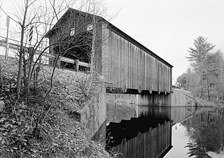
The Kingsley Covered Bridge is a wooden covered bridge carrying East Street across the Mill River in Clarendon, Vermont. Built about 1870, it is the town's only surviving 19th-century covered bridge. The bridge was listed on the National Register of Historic Places in 1974.

The Starr Mill Road Bridge is a historic bridge in Middletown, Connecticut. It is a single span Warren through truss bridge, spanning the Coginchaug River near the Starr Mill complex on the west bank of the river. Built in 1927 by the Berlin Construction Company, it is one of a shrinking number of period metal truss bridges in the state. The bridge was listed on the National Register of Historic Places in 1993. It is closed to all forms of passage.

The Holyoke Canal System is a system of power canals in Holyoke, Massachusetts. It is split into three canals based on elevation and distance from the inlet at the Holyoke Dam- the First Level Canal, Second Level Canal, and Third Level Canal. Constructed over a period between 1847 and 1892, the Canal System, along with the Dam, is recognized as a Historic Mechanical Engineering Landmark by the American Society of Mechanical Engineers for its use in the development of the Venturi meter by Clemens Herschel, the first means of measuring large-scale flows, and the McCormick-Holyoke Turbine by John B. McCormick, which doubled the efficiency of turbines to more than 80% in its time.

The Hampden County Memorial Bridge is a reinforced-concrete arch bridge that spans the Connecticut River between Springfield, Massachusetts and West Springfield, Massachusetts, constructed in 1922. The bridge is owned by Massachusetts Highway Department. It spans 209 feet (64 m) and rises 29.71 feet (9.06 m) above the river.

Beaverkill Bridge, also known as Conklin Bridge, is a wooden covered bridge over the Beaver Kill north of the hamlet of Roscoe in the Town of Rockland, New York, United States, that carries Conklin Road through Beaverkill State Campground. It was erected in 1865, one of the first bridges over the river in what was then still a largely unsettled region of the Catskill Mountains.

Ascutney Mill Dam, also known as the Windsor Upper Dam and the Mill Pond Dam, is an arch-gravity dam which is one of the oldest and among the earliest storage dams in the United States. It is made of cut granite and is located in Windsor, Vermont in Windsor County near the Connecticut River, where it functioned as a source of hydropower and, later, hydroelectric power. It is on the ASCE list of historic civil engineering landmarks since 1970 and is listed on the National Register of Historic Places since January 09, 2007.

The Maple Street Covered Bridge, also called the Lower Covered Bridge and the Fairfax Covered Bridge, is a covered bridge that carries Maple Street across Mill Brook off State Route 104 in Fairfax, Vermont. Built in 1865, it is the town's only historic covered bridge, and is a rare two-lane covered bridge in the state. It was listed on the National Register of Historic Places in 1974.

The Grist Mill Covered Bridge, also known as the Scott Covered Bridge, the Bryant Covered Bridge, and the Canyon Covered Bridge, is a covered bridge that carries Canyon Road across the Brewster River, off Vermont Route 108 in Cambridge, Vermont. Built in the 19th century, it is one of a small number of surviving Burr arch truss bridges in the state, and is one of three left in Cambridge. It was listed on the National Register of Historic Places in 1974.

The County Farm Bridge is a historic stone arch bridge in Wilton, New Hampshire. Built in 1885, it carries Old County Farm over Whiting Brook, just south of its northern junction with Burton Highway in a rural section of northwestern Wilton. It is an unusually late and well-preserved example of a 19th-century stone arch bridge, and was listed on the National Register of Historic Places in 1981.

The Bement Covered Bridge is a historic wooden covered bridge on Center Road over the Warner River in Bradford, New Hampshire. A Long-truss bridge, it was built in 1854, and is one of New Hampshire's small number of surviving 19th-century covered bridges. It was listed on the National Register of Historic Places in 1976.
The Hancock–Greenfield Bridge is a historic covered bridge carrying Forest Road over the Contoocook River at the town line between Hancock and Greenfield, New Hampshire. The New Hampshire Department of Transportation covered bridge database refers to it as County Bridge. Built in 1937, it is the first wooden covered bridge in the northeastern United States to use modern engineering techniques. The bridge was listed on the National Register of Historic Places in 1981.

The Stony Brook Covered Bridge, also called the Moseley Covered Bridge, is a wooden covered bridge that crosses Stony Brook in Northfield, Vermont on Stony Brook Road. Built in 1899, it is one of two surviving 19th-century King post truss bridges in the state. It was listed on the National Register of Historic Places in 1974.

The Lower Cox Brook Covered Bridge is a wooden covered bridge that crosses Cox Brook in Northfield, Vermont on Cox Brook Road. Built in 1872, it is one of five surviving 19th-century covered bridges in the town, in the only place in Vermont where two historic bridges are visible from each other. It was listed on the National Register of Historic Places in 1974.
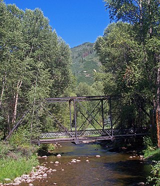
The Sheely Bridge, originally known as the Carbondale Bridge, carries pedestrian traffic across the Roaring Fork River at Mill Street Park in Aspen, Colorado, United States. It is a short steel truss bridge originally located downstream in Carbondale and later moved to its present location.

The Prentiss Bridge is a historic covered bridge in Langdon, New Hampshire. Built about 1874, it spans Great Brook just east of the modern alignment of Chester Turnpike, which it carried until it was bypassed by a modern bridge in 1955. At 36 feet (11 m) in length, it is the shortest 19th-century covered bridge built for use on a public roadway in New Hampshire that is still standing. The bridge was listed on the National Register of Historic Places in 1973.

The Waterman Covered Bridge was an historic covered bridge in Johnson, Vermont that carried Waterman Road across Waterman Creek. Built in 1868, it was one of three surviving 19th-century bridges in the town. It was listed on the National Register of Historic Places in 1974, and collapsed in January 1982.

The Robyville Bridge is a historic covered bridge in Corinth, Maine. Built in 1876, this Howe truss bridge is one of the state's few surviving 19th-century covered bridges. It carries Covered Bridge Road across Kenduskeag Stream in the southern part of the rural community. It was listed on the National Register of Historic Places in 1970 and designated as a Maine Historic Civil Engineering Landmark by the American Society of Civil Engineers in 2002.

The Martin's Mill Covered Bridge is a wooden covered bridge spanning Lull's Brook on Martinsville Road in Hartland, Vermont. Built about 1880, it is one of two surviving 19th-century covered bridges in the town. It was listed on the National Register of Historic Places in 1973.

The Red Covered Bridge is a historic covered bridge, carrying Cole Hill Road across Sterling Brook in Morristown, Vermont. Built in 1896, it is the only surviving 19th-century covered bridge in the town, and one of the last to be built during the historic period of covered bridge construction in the state. It is of queen post truss design, and was listed on the National Register of Historic Places in 1974.


