
The Gardner Uptown Historic District is a historic district encompassing the former civic heart of Gardner, Massachusetts. The 65-acre (26 ha) area includes the old town common, an early cemetery, and a modest number of non-residential buildings among a larger number of houses. The area was the center of civic life from the incorporation of Gardner in 1785 until municipal functions were moved to West Gardner beginning in the late 1920s. The district was listed on the National Register of Historic Places in 1999.

Westminster Village–Academy Hill Historic District encompasses the historic first town center of Westminster, Massachusetts, as well as its later early-19th century commercial core. Centered at the junction Main and South Streets with Academy Hill Road, it contains fine examples of Colonial, Federal, and Greek Revival architecture, including the 1839 town hall. The district was listed on the National Register of Historic Places in 1983.

The Harvard Center Historic District is a historic district encompassing the traditional village center of Harvard, Massachusetts, USA. The district is centered on the town common, a triangular grassy space bounded by Elm Street, Still River Road, and Ayer Road. The common is ringed by residences, civic and religious buildings, and a small commercial area. The common was laid out when the town was founded in 1732, and has grown, mainly in periods of growth at the late 18th and late 19th/early 20th centuries. Most of the village's buildings post-date 1831. The district was added to the National Register of Historic Places in 1997.

The Petersham Common Historic District encompasses the historic town center of Petersham, Massachusetts. Laid out in 1733 and centered on the town common bounded by Main and Common Streets, it retains most of its 19th-century character, with only a few turn-of-the-20th-century civic buildings adding later character. The district was added to the National Register of Historic Places in 1982.

The Ashfield Plain Historic District is a historic district roughly, along Main and South Streets and adjacent parts of Buckland and Norton Hill Roads in Ashfield, Massachusetts. It encompasses the village center of the town, which has acted as a civic and commercial center since the late 18th century. Its architectural heritage dates back to that time, but is now dominated by buildings from the late 19th and early 20th centuries. The district was listed on the National Register of Historic Places in 1991.

The Belchertown Center Historic District is a historic district which encompasses the historic village center of Belchertown, Massachusetts. Centered on Belchertown's 1,200-foot (370 m) common, the district includes 55 contributing properties along South Main Street, Maple Street, and a few adjacent streets. It was listed on the National Register of Historic Places in 1982.

The Main Street Historic District of Easthampton, Massachusetts encompasses the historic heart of the town, running along Main Street between Northampton and Center Streets. The area has been the civic and economic heart of the town since incorporation in 1785. Most of the commercial buildings date from the 1840s to the 1880s, and are built in an Italianate style. The housing stock of the district also includes Italianate styling, but there are also a number of Greek Revival structures. The major civic structures of the town are in the district, including the town hall, public library, and the First Congregational Church, which is the second for the congregation, a brick Romanesque Revival building dating to 1851. The district was added to the National Register of Historic Places in 1986.

The Bradford Common Historic District is a historic district encompassing the former town center of Bradford, now a village of Haverhill, Massachusetts. Centered on the former town common at South Main and Salem Streets, the area served as Bradford's civic and commercial center from about 1750 until its annexation by Haverhill in 1897, and retains architecture from the 18th to early 20th centuries. It was added to the National Register of Historic Places in 1977.

The River Road–Cross Street Historic District is a rural agricultural historic district in Topsfield, Massachusetts. It is representative of Topsfield's development first as an agricultural community, and later as place for rural retreats. The district, which was listed on the National Register of Historic Places in 2005, is roughly bounded by River Road, Rowley Bridge Road, Cross Street, Hill Street, and Salem Road, and also includes properties facing Prospect Street and Bradstreet Lane. Much of the district was consolidated under the ownership of William Appleton Coolidge in the 20th century, and bequeathed to the Massachusetts Institute of Technology with restrictions to preserve its rural character. MIT sold the donated properties in 2000.

The Shirley Village Historic District encompasses the main commercial and industrial village of Shirley, Massachusetts. It is located in the southern part of the town, and grew up around a series of mills that were located along Catacoonamug Brook, and then the railroad, which was built through the area in the 1840s. The district contains 441 properties. It is roughly bounded by Center, Harvard, Leominster and Shaker Roads. The district was listed on the National Register of Historic Places in 1992.

The Common Historic District is a historic district encompassing the civic and institutional heart of Reading, Massachusetts. The district is centered on the town common, at the intersection of Main and Salem Streets. The common has been communally owned since at least 1737, with the original burying ground to the north. In 1769 the area's first meeting house was built, giving the area a sense of identity separate from portions of Reading that would later be set off as Wakefield and North Reading. Since then the area has become a focal point for religious and civic institutions in the town.
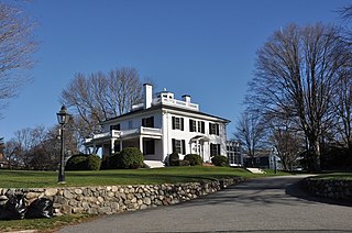
Beebe Homestead, also known as the Lucius Beebe House and Beebe Farm, is a historic Federal period home at 142 Main Street in Wakefield, Massachusetts, which was built during the federal era that extended from the late 18th-century into the 1820s. It is suspected to have been remodeled into the federal style from an earlier home built in circa 1727. It overlooks Lake Quannapowitt, and according to a 1989 study of historic sites in Wakefield, the house is "one of Wakefield's most imposing landmarks." The property was added to the National Register of Historic Places in 1989.

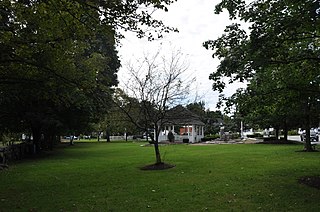
The Common District encompasses the main civic center of Wakefield, Massachusetts. It is centered on the historic town common, just south of Lake Quannapowitt, which was laid in 1644, when it became the heart of Old Reading. The area was separated from Reading as South Reading in 1818, and renamed Wakefield in 1868. The 25 acre district includes the buildings that line the common on Common Street and Main Street, which include the town hall, public library, YMCA, post office, and several churches. It was listed on the National Register of Historic Places in 1990.

The Salem Historic District is located along Main Street and Broadway in Salem, New York, United States. It is a 22-acre (8.9 ha) area containing 79 buildings.
The New Ipswich Center Village Historic District encompasses the historic center of the rural town of New Ipswich, New Hampshire. The center village is the town's most densely populated area, with a history dating to the town's founding in 1735. The district extends along Turnpike Road between King and Porter Roads, and southward in a roughly triangular shape, the southern point of which is at the junction of Main Street and Willard Road. The village includes a large number of residences, which were mainly agricultural at first, but also include a number of properties built as summer resort houses in the late 19th and early 20th centuries. It also includes most of the town's historic civic buildings, including its historic town hall, and the Barrett House, now a museum property owned by Historic New England. The district was listed on the National Register of Historic Places in 1991.
The Salem Common Historic District encompasses the early colonial center of Salem, New Hampshire. The district dates to the earliest period of settlement of Salem, and includes the historic common, old town hall, fire station, and library. The town hall was built in 1738 and extensively altered in 1838 and 1899; it served as a place for town meetings until 1958. The district was listed on the National Register of Historic Places in 2011.

The Town Center Historic District encompasses the historic village center of South Hampton, New Hampshire. Centered around the Barnard Green, the town common, on New Hampshire Route 107A, it includes architectural reminders of the town's growth and change over time. The district was listed on the National Register of Historic Places in 1983.

The Sharon Historic District encompasses the historic civic center of Sharon, Connecticut. Centered around a mile-long town green are an array of public civic and religious buildings, as well as residences from the 18th to 20th centuries. The area south of the green on South Main Street is lined with country houses developed or improved in the late 19th and early 20th centuries, representing one of the highest concentrations of Colonial Revival estates in the state. The district was listed on the National Register of Historic Places in 1993.

The Downtown Bennington Historic District encompasses the historic commercial heart of Bennington, Vermont. Centered on the junction of Main, South, and North Streets, it exhibits a variety of commercial architectural styles from the early 19th to mid-20th century. It was listed on the National Register of Historic Places in 1980, and was enlarged in 2008.

The Burlington–Harmony Hill Roads Historic District encompasses a historic rural agricultural crossroads village in eastern Harwinton, Connecticut. Stretching mainly along Harmony Hill Road north of its junction with Burlington Road, it includes residential buildings dating from the mid-18th to late 19th centuries. The district was listed on the National Register of Historic Places in 1996.


