
The Ashburnham Center Historic District is a historic district encompassing the core of the village center of Ashburnham, Massachusetts in the United States. It is a well-preserved industrial village that experienced its most significant period of growth in the mid-19th century. The district was added to the National Register of Historic Places in 1999.
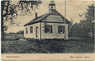
The West Goshen Historic District is a historic district in the village of West Goshen in the town of Goshen, Connecticut, United States. It encompasses a well-preserved early 19th-century industrial village, with twenty historically significant properties in the village, most of which lie on Connecticut Route 4 between Beach Street and Thompson Road. The district was listed on the National Register of Historic Places in 1987.

The Central Village Historic District is a historic district in the Central Village area of Plainfield, Connecticut, United States that was listed on the National Register of Historic Places (NRHP) in 1991. It encompasses a late 19th-century historic mill village, including a small commercial center where Connecticut Route 12 and 14 meet, a cluster of architecturally distinguished buildings built by mill owners and managers, and a collection of mill worker housing units. It includes the Plainfield Woolen Company Mill, which is separately listed, as well as archaeological remnants of other mill infrastructure. It also includes Plainfield's old town hall and high school. Other architecturally prominent buildings include the c. 1855 Italianate mansion of mill owner Arthur Fenner, and the 1845 Greek Revival Congregational Church.

The South Egremont Village Historic District encompasses most of the village of South Egremont, Massachusetts, a well-preserved village whose architecture has seen relatively little alteration since the 1840s. It is located along Massachusetts Route 23 in the plains east of the Taconic Mountains. The district was listed on the National Register of Historic Places in 1984.

The South Lee Historic District encompasses the historic portion of the village of South Lee in Lee, Massachusetts. Extending mainly along Massachusetts Route 102 between Fairview Street and the Stockbridge town line, the village is a well-preserved 19th-century mill village, with fine Federal and Greek Revival buildings and a later 19th-century paper mill. It was listed on the National Register of Historic Places in 1999.

The Heath Center Historic District encompasses a rural village with predominantly 18th- and 19th-century structures in Heath, a small agricultural town in hills of northwestern Franklin County, Massachusetts, United States. The district is centered on the junction of several roads, around which the center of the town grew. South Road arrives from the south, East Main Street and Bray Road from the east, Ledge Road from the north, and West Main Street from the west.

The Longmeadow Historic District is a historic district encompassing the village green of Longmeadow, Massachusetts and properties in its immediate vicinity. The district acquired local protection in 1973 and was added to the National Register of Historic Places in 1982.

The Granville Village Historic District is a historic district encompassing the historic Granville Village area in eastern Granville, Massachusetts. The area was developed in the 19th century as an industrial village, centered on the drum factory of Noble & Cooley on Dickinson Brook. The predominantly residential district includes a number of Greek Revival houses; it also includes the Colonial Revival public library building. It is located roughly in the area around the junction of Maple St. and Main and Granby Rds., including part of Water Street. The district was listed on the National Register of Historic Places in 1991.

The Shirley Village Historic District encompasses the main commercial and industrial village of Shirley, Massachusetts. It is located in the southern part of the town, and grew up around a series of mills that were located along Catacoonamug Brook, and then the railroad, which was built through the area in the 1840s. The district contains 441 properties. It is roughly bounded by Center, Harvard, Leominster and Shaker Roads. The district was listed on the National Register of Historic Places in 1992.

The East Jaffrey Historic District is a historic district running roughly along NH Route 124 through Jaffrey, New Hampshire. It encompasses what is now the economic and civic heart of the town, centered on the Jaffrey Mills and the crossing of the Contoocook River by Route 124. It extends as far west as St. Patrick's Church beyond Charlonne Street and as far east as the US Post Office building at Route 124 and Ellison Street. To the north it extends along Peterborough Street to Christian Court, and to the south it extends along River Street and School Street to their junction. The district includes early 19th-century residential structures, as well as industrial buildings and housing associated with the Jaffrey Mills which arose in the mid-19th century. The district was added to the National Register of Historic Places in 2002.

The Spring Hill Historic District encompasses a rural 19th-century village stretching along Storrs Road in Mansfield, Connecticut. Spring Hill developed as a rural waystation on an early 19th-century turnpike, and has seen only modest development since the late 19th century. The district was listed on the National Register of Historic Places in 1979.

The Head of the River Historic District is a historic district encompassing a village area at the head of navigation of the Acushnet River, which separates Acushnet and New Bedford, Massachusetts. The village is centered at the junction of Tarkin Hill Road, River Road, and Mill Road in New Bedford, and Main Street in Acushnet. The area went through two significant periods of development: the first was in the late 18th and early 19th century, and the second was in the early 20th century. The district was listed on the National Register of Historic Places in 2009.

The Jaffrey Center Historic District encompasses the traditional civic heart of the small town of Jaffrey, New Hampshire. The district lies to the west of the Jaffrey's main business district, extending along Main Street from Harkness Road to the Jaffrey Common, and along Thorndike Pond Road northward from Main Street. It includes the town's oldest civic buildings, and was its main center until the mills of East Jaffrey eclipsed it. The district was listed on the National Register of Historic Places in 1975.
The New Ipswich Center Village Historic District encompasses the historic center of the rural town of New Ipswich, New Hampshire. The center village is the town's most densely populated area, with a history dating to the town's founding in 1735. The district extends along Turnpike Road between King and Porter Roads, and southward in a roughly triangular shape, the southern point of which is at the junction of Main Street and Willard Road. The village includes a large number of residences, which were mainly agricultural at first, but also include a number of properties built as summer resort houses in the late 19th and early 20th centuries. It also includes most of the town's historic civic buildings, including its historic town hall, and the Barrett House, now a museum property owned by Historic New England. The district was listed on the National Register of Historic Places in 1991.

The Newmarket Industrial and Commercial Historic District encompasses the heart of a distinctive 19th century mill town, Newmarket, New Hampshire. Its mill complex is regionally distinctive for its extensive use of stone from an early date, and the town is relatively well-preserved due to a significant economic decline after the mills closed in 1920. The district was listed on the National Register of Historic Places in 1980. The Stone School, listed in 1978, is a contributing resource.

The Putney Village Historic District encompasses most of the main village and town center of Putney, Vermont. Settled in the 1760s, the village saw its major growth in the late 18th and early 19th century, and includes a cohesive collection with Federal and Greek Revival buildings, with a more modest number of important later additions, including the Italianate town hall. The district was listed on the National Register of Historic Places in 1986.
The Wilmington Village Historic District encompasses a significant portion of the village center of Wilmington, Vermont. The village grew as a crossroads industrial center through the mid-19th century, and experienced relatively little growth afterward. The district was listed on the National Register of Historic Places in 1980.

The Weston Village Historic District encompasses the town center and principal village of Weston, Vermont. Centered on Farrar Park, which serves as the town green, it includes a diversity of architectural styles from the late 18th century to about 1935, and includes residential, civic, commercial, industrial and religious buildings. It was listed on the National Register of Historic Places in 1985.

The Tunbridge Village Historic District encompasses the early 19th-century village center of Tunbridge, Vermont. Stretched linearly along Vermont Route 110, the largely agricultural village reached its peak population around 1820, and was bypassed by the railroads, limiting later development. It was listed on the National Register of Historic Places in 1994.
The Oakham Center Historic District encompasses a portion of the historic town center of Oakham, Massachusetts. Roughly bounded by Coldbrook Rd., Maple St., Barre Rd., and Deacon Allen Drive, the area was formed as a civic center about 1770, with town incorporation following in 1775. It includes a well-preserved variety of early 19th-century residential architecture, as well as the town's Greek Revival Congregational church, and its 1908 library. The district was listed on the National Register of Historic Places in 2020.


