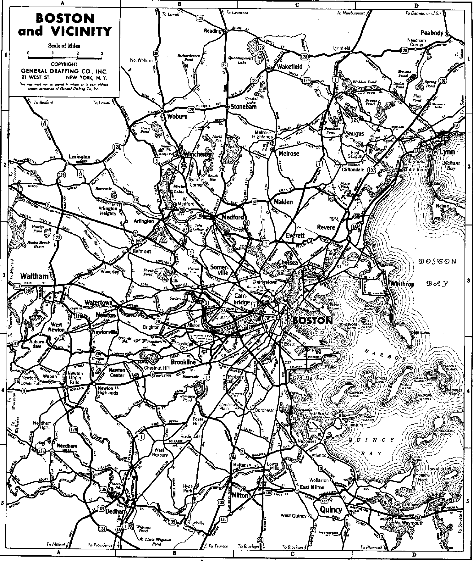
Massachusetts Route 2

Last updated

MA Route 2.svg
Route 2
Massachusetts Route 2
Route 2 highlighted in red
Route information
Maintained by MassDOT
Length142.29 mi [1]  (228.99 km)
Existed1927, 1971 (current alignment)–present
Major junctions
West endNY-2.svg NY 2 at the New York state line
Major intersections
East endMA Route 28.svg Route 28 in Boston
Location
Country United States
State Massachusetts
Counties Berkshire, Franklin, Worcester, Middlesex, Suffolk, Norfolk
Highway system
MA Route C1.svg Route C1 MA Route 2A.svg Route 2A
New England 6B.svg Route 6B N.E. New England 8.svg Route 8

Route 2 is a 142.29-mile-long (228.99 km) major eastwest state highway in Massachusetts, United States. Along with Route 9 and U.S. Route 20 to the south, these highways are the main alternatives to the Massachusetts Turnpike/I-90 toll highway. Route 2 runs the entire length of the northern tier of Massachusetts, beginning at the New York border, where it connects with New York State Route 2, and ending near Boston Common in Boston. Older alignments of Route 2 are known as Route 2A.

Contents

Route description

Berkshire and Franklin counties

Route 2 proceeds east from the New York state line on a winding, scenic path in Berkshire County through Williamstown, where it serves the Williams College area, and through North Adams, where it serves the Massachusetts College of Liberal Arts. East of North Adams, Route 2 ascends via a hairpin turn into the Hoosac Range along what is known as the Mohawk Trail.

Route 2 then enters Franklin County, meeting Interstate 91 at an interchange in Greenfield and briefly runs concurrently with I-91. While the old Route 2 becomes Route 2A and goes through downtown Greenfield, Route 2 joins I-91 in a short concurrency before leaving it and becoming a two-lane freeway. Outside Greenfield, Route 2A temporarily ends and merges with Route 2, and Route 2’s freeway section ends. Route 2 remains a two-lane surface road in Gill and Millers Falls (though it does have an interchange with Route 63). The road in Erving was routed to the north and straightened to avoid the paper mill next to the river. This rerouting led to the road being shortened by less than one-tenth of a mile.

Orange–Cambridge

As the route approaches Orange, Route 2A resumes and diverges from Route 2. At this point, Route 2 again becomes a two-lane freeway. In Orange, Route 2 runs concurrently with U.S. Route 202. The road at this point enters the town of Athol in Worcester County. After its eastern interchange in Phillipston when US-202 departs to the north, Route 2 becomes a four-lane freeway, though not to Interstate standards at most points. It continues through Gardner into Fitchburg where Route 2 has several at-grade intersections with Oak Hill Rd, Palmer Rd, Mt. Elam Rd and Abbott Ave. At the intersection with Mt. Elam Rd, a traffic light remains in use on the eastbound side. Continuing east into Leominster, Interstate 190 splits off, heading south to Worcester.

Route 2 continues east to Middlesex County and enters Boston's outer loop at the interchange with Interstate 495 in Littleton. It continues into Acton, where Route 2 reduces its speed to 45 miles per hour, and becomes a four-lane expressway with at-grade intersections. At the Concord Rotary, a major traffic choke point, Route 2 becomes a four-lane surface road and intersects with Route 2A and the eastern terminus of Route 119 (which is concurrent with Route 2A). After the rotary, the road passes by the State Police (who have an emergency-only traffic light) and over the Assabet River. Route 2A formerly broke away from Route 2 at the next traffic light to go left into Concord but is now overlaid with Route 2, where it becomes a four-lane expressway again. At Crosby's Corner, the sixth intersection after the rotary, Route 2A exits under the highway while Route 2 veers right (but still heads east). After a signalized at-grade intersection with Bedford Road in Lincoln, the highway becomes a four-lane arterial road.

Convergence of Routes 2, 3, and 16 in Cambridge. Massachusetts Route 2 at Alewife, Cambridge.jpg
Convergence of Routes 2, 3, and 16 in Cambridge.

Route 2 enters Lexington and heads to Boston's inner belt, and as it crosses Interstate 95/Route 128, it becomes a six-lane freeway with a speed limit of 55 miles per hour. In Belmont, Route 2 remains a six-lane freeway, and then becomes an eight-lane freeway at Exit 132 (formerly 57) in Arlington, where U.S. Route 3 would have joined it from the north. At Exit 135 (formerly 60), the freeway narrows in width to six lanes. The section of freeway from Route 128 to the Cambridge line meets the standards of an interstate highway.[ citation needed ] The highway enters Cambridge, the highway reduces its speed limit back to 45 miles per hour and becomes a five-lane freeway (three lanes heading east, two lanes heading west), with a strip of residential and transit-oriented development on its eastbound side, including an off-ramp that serves the MBTA Alewife Station, Cambridge Discovery Park and development to the south and west of the station. After the Alewife exit, the highway narrows again to four lanes.

Cambridge and Boston

The shield for Massachusetts Route 2, located across from Boston Common Massachusetts Route 2 in Boston.JPG
The shield for Massachusetts Route 2, located across from Boston Common

The highway then meets a large at-grade intersection with Routes 3 and 16, where Route 2 east merges with U.S. Route 3 south and Route 16 and continues as a four-lane, 35 mile per hour arterial road — managed by the Department of Conservation and Recreation — for the rest of its time in Cambridge. Route 2 follows Alewife Brook Parkway and Fresh Pond Parkway along its wrong way concurrency with Routes 3 and 16, before Route 16 heads west into Watertown. Route 2 and Route 3 concurrently start paralleling the Charles River as Memorial Drive, passing by Harvard University’s campus. It then heads southward on the Boston University Bridge into Boston proper, as it separates from Route 3. It winds through the Boston University campus as Mountfort Street and crosses over both the Massachusetts Turnpike and Commonwealth Avenue before heading due east towards Kenmore Square, while running parallel to U.S. Route 20. Immediately east of the Boston University campus, it crosses into Kenmore Square, which is also the eastern terminus of U.S. Route 20. From Kenmore Square, Route 2 follows Commonwealth Ave to Arlington St. It circles the Boston Public Garden, using Arlington, Boylston, and Charles Streets. Route 2 east goes along northbound Route 28 north at the intersection of Charles and Beacon Streets between Boston Common and the Boston Public Garden. As Route 28 north joins Storrow Drive, which shortly after would join Route 3, Route 28 south joins Route 2 and completes the loop around Boston Public Garden.

History

The route amalgamates and supersedes various named highways in some cases going back to the pre-automobile era. For example, parts of Route 2 are sometimes known as the Cambridge and Concord Turnpike and the Mohawk Trail.

New England 7.svg

In the early 1920s, Route 2 was known as New England Interstate Route 7 (NE-7), a major road in the New England road marking system connecting Boston with Troy, New York. NE-7 ran roughly where Route 2A (the original surface alignment of Route 2) does now except near the New York state line. NE-7 used current Massachusetts Route 43, New York State Route 43 and New York State Route 66 to reach Troy. Current Route 2 from Williamstown to Petersburgh was previously numbered as Route 96.

Route 2 connected as a highway in its current right-of-way at Alewife Brook Parkway at some point before 1937. [2]

An upgraded Route 2 was originally planned to continue as Boston's Northwest Expressway (merging with a re-routed U.S. Route 3 at the Arlington-Lexington or Arlington-Cambridge border) to a junction with Interstate 695, the Inner Beltway, but this, along with the Inner Beltway itself, was cancelled in 1970, accounting for the abrupt narrowing at Alewife. [3] [4] In place of the highway project, the MBTA Red Line was extended from Harvard to Alewife in the 1980s.[ citation needed ]

The Leominster to Ayer section opened on July 3, 1953, completing the expressway portion from Westminster to West Concord. [5] Full grade separation between Route 128 and Alewife Brook Parkway was completed around 1970.

Crosby's Corner intersection

This major project has been planned since 1999. The intersection had an average of 90 accidents a year. The project was intended to solve the traffic and safety problems that had long occurred at the Crosby's Corner intersection (junction of Route 2 and 2A) in Concord. The project, which was expected to cost $71.9 million, widened Route 2 from Bedford Rd in Lincoln to 300 feet west of Sandy Pond Rd in Concord. The project eliminated the at grade intersection, realigned Route 2, and constructed new entrance and exit ramps along with new service roads next to Route 2.

The full project included building a new overpass bridge over Route 2 and building multiple service roads next to Route 2. Work also consisted of a new signalized intersection. The project was put out to bid for contractors on September 19, 2011. A contractor was expected to be chosen over the winter and construction was expected to begin in Spring 2012 on the estimated $55 million project.

The Army Corps of Engineers published a notice [6] for this project, because of its impact on wetlands at Crosby's Corner. During the summer of 2012, activity on this portion of Route 2 included surveying and the installation of orange-painted stakes. Signs were added in January 2013 indicating that construction would start on January 14. As of April 2014 the project was underway and predicted completion was spring 2016. [7] The project was completed in 2016, with a large improvement in traffic flow.[ citation needed ]

Future

A project to improve the Concord Rotary, at the convergence of Route 2, Route 2A/119 (Elm Street), Barrett's Mill Road and Commonwealth Avenue, has been in planning since 2003 or even earlier. More than 61,000 cars use this rotary on a typical day, and the backed up traffic can be significant. The improved intersection would include overpasses for local streets, while Route 2 traffic would continue unimpeded at grade. However, the project was removed from the funded portion of the Boston Region Metropolitan Planning Organization's (MPO) Long Range Transportation Plan (LRTP) in August 2009 and is currently on hold. [8]

Major intersections

MassDOT was scheduled to replace the old sequential exit numbers with the new milepost-based exit numbers beginning in summer 2020, [9] [10] which had been delayed since 2016. [11] [12] On March 16, 2021, MassDOT announced that the Route 2 exit numbers would get renumbered for four weeks starting on March 23.

CountyLocation [13] mi [13] kmOld exit [14] New exit [10] DestinationsNotes
Berkshire Williamstown 0.0000.000West plate.svg
NY-2.svg
NY 2 west Troy NY
Continuation into New York
3.8246.154South plate.svg
US 7.svg
US 7 south Pittsfield
Western end of concurrency with US 7
6.22110.012North plate.svg
US 7.svg
US 7 north Pownal VT, Montreal Que
Eastern end of concurrency with US 7
6.74610.857South plate.svg
MA Route 43.svg
Route 43 south Hancock, Stephentown NY
Northern terminus of Route 43
North Adams 11.57118.622South plate.svg
MA Route 8.svg
Route 8 south Adams [15]
Western end of concurrency with Route 8
11.74018.894South plate.svg
MA Route 8A.svg
Route 8A south
Northern terminus of Route 8A "U" segment
12.40519.964North plate.svg
MA Route 8.svg
Route 8 north Clarksburg, Stamford VT
Eastern end of concurrency with Route 8
Franklin Charlemont 29.80747.970South plate.svg
MA Route 8A.svg
Route 8A south Hawley, Windsor
Western end of concurrency with Route 8A
30.448.9North plate.svg
MA Route 8A.svg
Route 8A north Heath, Jacksonville VT
Eastern end of concurrency with Route 8A
Buckland 37.39060.173East plate.svg
MA Route 2A.svg
Route 2A east Shelburne Falls
Former western terminus of Route 2A
37.80660.843South plate.svg
MA Route 112.svg
Route 112 south Buckland, Ashfield
Western end of concurrency with Route 112
Shelburne 38.06261.255North plate.svg
MA Route 112.svg
Route 112 north Shelburne Falls, Colrain
Eastern end of concurrency with Route 112
38.94262.671West plate.svg
MA Route 2A.svg
Route 2A west Shelburne Falls, Buckland
Former western end of concurrency with Route 2A
Greenfield 47.39876.280Western end of freeway section
2643South plate blue.svg
I-91.svg
East plate.svg
MA Route 2A.svg
I-91 south / Route 2A east Springfield, Greenfield Center
Western end of concurrency with I-91; western terminus of Route 2A
50.13980.6912746North plate blue.svg
I-91.svg
I-91 north Brattleboro VT
Eastern end of concurrency with I-91; exit number not signed westbound
50.78981.737US 5.svgMA Route 10.svg US 5  / Route 10  Greenfield, Bernardston
51.48082.849Eastern end of freeway section
52.24284.075West plate.svg
MA Route 2A.svg
Route 2A west Greenfield Center
Western end of concurrency with Route 2A
Erving 57.191.9To plate.svg
MA Route 63.svg
To Route 63  Northfield, Millers Falls
Access via Gateway Drive
57.492.4To plate.svg
MA Route 63.svg
To Route 63  Northfield, Hinsdale NH
Access via Forest Street
57.792.9To plate.svg
MA Route 63.svg
To Route 63  Millers Falls
Access via Prospect Street
64.865104.390East plate.svg
MA Route 2A.svg
To plate.svg
MA Route 78.svg
Route 2A east to Route 78  Orange, Wendell [16]
Eastern end of concurrency with Route 2A
65.060104.704Western end of limited-access section
Orange 66.571107.1361467West River Street Orange, Lake Mattawa
69.788112.3131570MA Route 122.svg Route 122  Orange Ctr, Worcester
70.676113.7421671South plate.svg
US 202.svg
US 202 south / Daniel Shays Highway Belchertown, Athol
Western end of concurrency with US 202
Worcester Athol 75.155120.9501775MA Route 32.svg Route 32  Athol, Petersham
Phillipston 76.474123.0731877MA Route 2A.svg Route 2A  Athol, Phillipston
79.009127.1531979North plate.svg
US 202.svg
MA Route 2A.svg US 202 north / Route 2A  Baldwinville, Winchendon, Phillipston
Eastern end of concurrency with US 202
Templeton 81.915131.8292082Baldwinville Road Templeton, Baldwinville
83.459134.3142183MA Route 2A.svgMA Route 101.svg Route 2A  / Route 101  East Templeton, Ashburnham
Gardner 86.500139.2082286MA Route 68.svg Route 68  Gardner, Hubbardston
87.253140.4202387Pearson Boulevard Gardner
Westminster 89.738144.4192490North plate.svg
MA Route 140.svg
Route 140 north / West Main Street Winchendon, Westminster
Western end of concurrency with Route 140; signed as exits 90A (south) and 90B (north) westbound [10]
91.764147.6802592MA Route 2A.svgSouth plate.svg
MA Route 140.svg
Route 2A  / Route 140 south Westminster
Eastern end of concurrency with Route 140
92.568148.9742693Willard Road / Village Inn RoadEastbound exit only
93.479150.4402794Narrows Road / Depot Road
Fitchburg 94.495152.0752895MA Route 31.svg Route 31  Fitchburg, Princeton
FitchburgLeominster line96.279154.94629Mount Elam Road Right-in/right-out connections only
98.007157.7273098Merriam Avenue / South Street
Leominster 99.269–
99.278
159.758–
159.772
3199MA Route 12.svg Route 12  Fitchburg, Leominster Signed as exits 99A (south) and 99B (north) westbound [10]
100.355161.50632100MA Route 13.svg Route 13  Leominster, Lunenburg
101.125162.74533101South plate blue.svg
I-190.svg
I-190 south / Mechanic Street Worcester, Leominster
Northern terminus and exits 19B-A on I-190
Lancaster 102.429164.84334102Mechanic Street / Harvard StreetExit partially in Leominster
103.497166.56235103South plate.svg
MA Route 70.svg
Route 70 south (Lunenburg Road) Lancaster, Lunenburg
Northern terminus of Route 70
104.917168.84836105Shirley Road Shirley
106.419171.26537106Jackson Road Devens, Reserve Forces Training AreaSigned as exits 106A (no public access) and 106B westbound; exit partially in Harvard [10]
Harvard 109.348–
109.357
175.979–
175.993
38109MA Route 110.svgMA Route 111.svg Route 110  / Route 111  Harvard, Ayer Signed as exits 109A (south/west) and 109B (north/east) [10]
Middlesex Littleton 113.050181.93639112Taylor Street Littleton
113.285–
113.317
182.315–
182.366
40113I-495.svg I-495  Marlboro, Lowell Signed as exits 113A (south) and 113B (north); [10] exits 78A-B on I-495 [17]
Boxborough 115.505185.88741115Newtown Road West Acton, Littleton
Acton 117.612189.27842117MA Route 27.svg Route 27  Maynard, Acton
118.013189.92443118North plate.svg
MA Route 111.svg
Route 111 north West Acton
Westbound left exit and eastbound entrance; western terminus of concurrency with Route 111
Concord 120.465193.870Eastern end of limited-access section
West plate.svg
MA Route 2A.svg
West plate.svg
MA Route 119.svg
Route 2A west / Route 119 west Littleton
End plate.svg
MA Route 111.svg
Route 111 ends
Rotary; western end of concurrency with Route 2A; eastern terminus of Route 119; southern terminus of Route 111
Western end of limited-access section
121.691195.843MA Route 62.svg Route 62 (Main Street) West Concord, Maynard, Concord Ctr, Bedford At-grade intersection
123.901199.399South plate.svg
MA Route 126.svg
To plate.svg
MA Route 117.svg
Route 126 south (Walden Street) to Route 117  Walden Pond, Waltham
At-grade intersection; northern terminus of Route 126
124.824200.88550125East plate.svg
MA Route 2A.svg
Route 2A east Concord, Lincoln
Eastern end of concurrency with Route 2A
Lincoln 126.256203.18951Bedford RoadAt-grade intersection; to Route 2A
Eastern end of limited-access section
Lexington 128.527206.844Western end of freeway section
52127I-95.svgMA Route 128.svg I-95  / Route 128  Attleboro, Peabody Signed as exits 127A (south) and 127B (north); exits 45A-B on I-95
129.010207.62153128Spring Street Lexington No westbound exit
130.002209.21854129Waltham Street Lexington, Waltham Westbound exit and eastbound entrance; signed as exits 129A (south) and 129B (north) [10]
130.894210.65355130Pleasant Street Lexington Eastbound exit and westbound entrance
131.435211.52456131Winter Street Belmont No westbound exit
North plate.svg
MA Route 4.svg
West plate.svg
MA Route 225.svg
Route 4 north / Route 225 west Lexington, Bedford
No eastbound exit; southern terminus of Route 4; eastern terminus of Route 225
ArlingtonBelmont line131.990212.41757132Dow Avenue Arlington, Belmont
Belmont 132.711213.57858133Park Avenue Arlington
BelmontArlington line133.690215.15359134MA Route 60.svg Route 60  Belmont, Arlington
ArlingtonBelmont
Cambridge tripoint
134.130215.86160135Lake Street East Arlington
Cambridge 134.649216.697Rail Sign.svg Alewife station Eastbound exit only
134.915217.125Eastern end of freeway section
135.005217.269North plate.svg
US 3.svg
East plate.svg
MA Route 16.svg
US 3 north / Route 16 east (Alewife Brook Parkway) Medford, Woburn
Western end of concurrency with US 3 / Route 16
136.354219.440West plate.svg
MA Route 16.svg
Route 16 west (Huron Avenue) Watertown, West Newton
Eastern end of concurrency with Route 16
139.280224.149South plate.svg
US 3.svg
US 3 south (Memorial Drive)
Eastern end of concurrency with US 3
Charles River 139.349224.260 Boston University Bridge
Suffolk Boston 139.531224.553US 20.svg US 20 (Commonwealth Avenue) Brighton, Kenmore Square
Norfolk
No major junctions
Suffolk Boston 140.446226.026West plate.svg
US 20.svg
US 20 west (Commonwealth Avenue)
Kenmore Square; eastern terminus of US 20
140.881226.726West plate.svg
MA Route 2A.svg
Route 2A west (Massachusetts Avenue)
Eastern terminus of Route 2A
141.556227.812South plate.svg
MA Route 28.svg
Route 28 south (Clarendon Street)
One-way southbound
142.35229.09 Beacon Street Eastern terminus
1.000 mi = 1.609 km; 1.000 km = 0.621 mi

See also

References

  1. Executive Office of Transportation. "Office of Transportation Planning - 2005 Road Inventory". Archived from the original on September 27, 2006.
  2. General Drafting (1937). Boston and Vicinity (Map). Scale not given. New York: General Drafting. Archived from the original on May 17, 2011.
  3. "Figure X-7: Plan for Roadway Circulation" (Map). Boston Highway Plan 1965. Archived from the original on July 8, 2011. Retrieved April 17, 2010.
  4. BigRock (April 9, 2007). "Boston's Cancelled Highways" . Retrieved December 30, 2010 via Google Maps.
  5. "Part of Sullivan Sq. Span Open Today, Rte. 2 July 3". Boston Globe. June 23, 1953. pp. 1, 12 via Newspapers.com.
  6. army.mil [ dead link ]
  7. "Concord, MA - Crosby's Corner Project". Archived from the original on April 16, 2014. Retrieved March 25, 2014.
  8. "Route 2 Concord Rotary Reconstruction Project". Archived from the original on November 7, 2014. Retrieved March 25, 2014.
  9. "Milepost-based Exit Renumbering" (PDF). Massachusetts Department of Transportation. December 5, 2019. Retrieved December 5, 2019.
  10. 1 2 3 4 5 6 7 8 "Route 2 Renumbering" (PDF). Massachusetts Department of Transportation. December 5, 2019. Retrieved December 5, 2019.
  11. "No signs yet from Massachusetts on exit-conversion launch". berkshireeagle.com. Retrieved April 22, 2018.
  12. Commonwealth of Massachusetts (2015). "COMMBUYS - Bid Solicitation FAP# HSIP-002S(874) Exit Signage Conversion to Milepost-Based Numbering System along Various Interstates, Routes and the Lowell Connector" . Retrieved January 6, 2016.
  13. 1 2 "MassDOT Route Log Application". Massachusetts Department of Transportation. Retrieved November 21, 2019.
  14. "Major highway routes and exits". Massachusetts Department of Transportation. Archived from the original on October 15, 2019. Retrieved November 21, 2019.
  15. "MA-8A, North Adams, Massachusetts". Google Street View . July 2014. Retrieved January 27, 2015.
  16. "248 MA-2, Erving, Massachusetts". Google Street View. October 2011. Retrieved January 22, 2015.
  17. "I-495 Renumbering" (PDF). Massachusetts Department of Transportation. December 5, 2019. Retrieved December 5, 2019.
Template:Attached KML/Massachusetts Route 2
KML is from Wikidata