Hinsdale (CDP), New Hampshire

Last updated

Hinsdale, New Hampshire
Main Street, Hinsdale NH.jpg
Main Street
USA New Hampshire location map.svg
Red pog.svg
Hinsdale
Usa edcp location map.svg
Red pog.svg
Hinsdale
Coordinates: 42°47′12″N72°28′51″W / 42.78667°N 72.48083°W / 42.78667; -72.48083
Country United States
State New Hampshire
County Cheshire
Town Hinsdale
Area
[1]
  Total2.40 sq mi (6.21 km2)
  Land2.32 sq mi (6.02 km2)
  Water0.08 sq mi (0.20 km2)
Elevation
250.7 ft (76.4 m)
Population
 (2020)
  Total1,485
  Density639.26/sq mi (246.87/km2)
Time zone UTC-5 (Eastern (EST))
  Summer (DST) UTC-4 (EDT)
ZIP code
03451
Area code 603
FIPS code 33-36580
GNIS feature ID2378072

Hinsdale is a census-designated place (CDP) and the main village in the town of Hinsdale in Cheshire County, New Hampshire, United States. The population of the CDP was 1,485 at the 2020 census, [2] out of 3,948 in the entire town of Hinsdale.

Contents

Geography

The CDP is in the south-central part of the town of Hinsdale, between the Connecticut River to the west and the Winchester town line to the east. The Ashuelot River, a tributary of the Connecticut, flows through the eastern and southern part of the CDP. New Hampshire Route 119 passes through the center of the village as Brattleboro Road, Main Street, and Canal Street; it leads east 6 miles (10 km) to Winchester and northwest 7 miles (11 km) to Brattleboro, Vermont. New Hampshire Route 63 joins Route 119 along Main Street in the center of Hinsdale, but leads north 8 miles (13 km) to Chesterfield and south 7 miles (11 km) to Northfield, Massachusetts.

According to the U.S. Census Bureau, the Hinsdale CDP has a total area of 2.4 square miles (6.2 km2), of which 2.3 square miles (6.0 km2) are land and 0.1 square miles (0.2 km2), or 3.20%, are water. [3]

Demographics

Historical population
CensusPop.Note
1950 1,247
1960 1,235−1.0%
1970 1,059−14.3%
1980 1,54646.0%
1990 1,71811.1%
2000 1,713−0.3%
2010 1,548−9.6%
2020 1,485−4.1%
U.S. Decennial Census [4]

As of the census of 2010, there were 1,548 people, 666 households, and 393 families residing in the Hinsdale CDP. There were 733 housing units, of which 67, or 9.1%, were vacant. The racial makeup of the town was 97.5% White, 0.5% African American, 0.1% Native American, 0.3% Asian, 0.2% Pacific Islander, 0.8% some other race, and 0.6% from two or more races. 1.2% of the population were Hispanic or Latino of any race. [5]

Of the 666 households in the CDP, 30.3% had children under the age of 18 living with them, 42.0% were headed by married couples living together, 11.9% had a female householder with no husband present, and 41.0% were non-families. 31.4% of all households were made up of individuals, and 13.5% were someone living alone who was 65 years of age or older. The average household size was 2.32, and the average family size was 2.92. [5]

22.8% of people in the CDP were under the age of 18, 8.5% were from 18 to 24, 23.7% were from 25 to 44, 29.8% were from 45 to 64, and 15.2% were 65 years of age or older. The median age was 41.7 years. For every 100 females, there were 93.0 males. For every 100 females age 18 and over, there were 88.8 males. [5]

For the period 2011-15, the estimated median annual income for a household was $38,981, and the median income for a family was $59,176. The per capita income for the town was $21,355. 10.5% of the population and 2.7% of families were below the poverty line, along with 4.0% of people under the age of 18 and 15.7% of people 65 or older. [6]

Related Research Articles

<span class="mw-page-title-main">West Swanzey, New Hampshire</span> Census-designated place in New Hampshire, United States

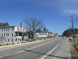
West Swanzey is a census-designated place (CDP) in the town of Swanzey within Cheshire County, New Hampshire, United States. The population was 1,281 at the 2020 census. It is the largest village in the town of Swanzey.

<span class="mw-page-title-main">East Merrimack, New Hampshire</span> Census-designated place in New Hampshire, United States

East Merrimack is a census-designated place (CDP) in the town of Merrimack, Hillsborough County, New Hampshire, United States. There is no village center named "East Merrimack"; rather, the CDP refers to the region of the town of Merrimack lying east of the F. E. Everett Turnpike, overlapping portions of the villages of Reeds Ferry, Thornton's Ferry, and the center of Merrimack. The population was 5,176 at the 2020 census, up from 4,197 at the 2010 census.

<span class="mw-page-title-main">Suncook, New Hampshire</span> Census-designated place in New Hampshire, United States

Suncook is a census-designated place (CDP) in Merrimack County, New Hampshire, United States. The population was 5,501 at the 2020 census. Approximately two-thirds of Suncook is located in the town of Pembroke, with the remainder in Allenstown.

<span class="mw-page-title-main">Vernon, Vermont</span> Town in Vermont, United States

Vernon is a town in Windham County, Vermont, in the United States. The population was 2,192 at the 2020 census. Vernon is the site of the now-defunct Vermont Yankee, the state of Vermont's only nuclear power plant, which closed in December 2014.

<span class="mw-page-title-main">Hinsdale, New Hampshire</span> Town in New Hampshire, United States

Hinsdale is a town in Cheshire County, New Hampshire, United States. The population was 3,948 at the 2020 census. Hinsdale is home to part of Pisgah State Park in the northeast, and part of Wantastiquet Mountain State Forest in the northwest.

<span class="mw-page-title-main">Winchester (CDP), New Hampshire</span> Census-designated place in New Hampshire, United States

Winchester is a census-designated place (CDP) and the main village in the town of Winchester in Cheshire County, New Hampshire, United States. The population of the CDP was 1,606 at the 2020 census, compared to 4,150 in the entire town.

<span class="mw-page-title-main">Winchester, New Hampshire</span> Town in New Hampshire, United States

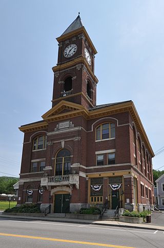
Winchester is a town in Cheshire County, New Hampshire, United States. The population was 4,150 at the 2020 census. The primary community in the town, where 1,606 people resided at the 2020 census, is defined by the U.S. Census Bureau as the Winchester census-designated place (CDP). The town also includes the village of Ashuelot and part of Pisgah State Park.

Lancaster is a census-designated place (CDP) and the main village in the town of Lancaster in Coos County, New Hampshire, United States. The population of the CDP was 1,941 at the 2020 census, out of 3,218 in the entire town of Lancaster.

<span class="mw-page-title-main">Bristol (CDP), New Hampshire</span> Census-designated place in New Hampshire, United States

Bristol is a census-designated place (CDP) and the main village in the town of Bristol in Grafton County, New Hampshire, United States. The population of the CDP was 1,911 at the 2020 census, out of 3,244 in the entire town.

Littleton is a census-designated place (CDP) and the main village in the town of Littleton in Grafton County, New Hampshire, United States. The population of the CDP was 4,467 at the 2020 census, out of 6,005 in the entire town.

<span class="mw-page-title-main">Plymouth (CDP), New Hampshire</span> Census-designated place in New Hampshire, United States

Plymouth is a census-designated place (CDP) and the main village in the town of Plymouth in Grafton County, New Hampshire, United States. Its population was 4,730 at the 2020 census, out of 6,682 in the entire town. The CDP includes the campus of Plymouth State University.

<span class="mw-page-title-main">Hampton (CDP), New Hampshire</span> Census-designated place in New Hampshire, United States

Hampton is a census-designated place (CDP) comprising the town center and surrounding developed areas of the town of Hampton, Rockingham County, New Hampshire, United States. The population of the CDP was 9,597 at the 2020 census, out of 16,214 in the entire town.

<span class="mw-page-title-main">Durham (CDP), New Hampshire</span> Census-designated place in New Hampshire, United States

Durham is a census-designated place (CDP) and the main village in the town of Durham in Strafford County, New Hampshire, United States. The population of the CDP was 11,147 at the 2020 census, out of 15,490 in the entire town. The CDP is home to the University of New Hampshire.

<span class="mw-page-title-main">Farmington (CDP), New Hampshire</span> Census-designated place in New Hampshire, United States

Farmington is a census-designated place (CDP) and the main village in the town of Farmington, Strafford County, New Hampshire, United States. The population of the CDP was 3,824 at the 2020 census, out of 6,722 in the entire town.

<span class="mw-page-title-main">Charlestown (CDP), New Hampshire</span> Census-designated place in New Hampshire, United States

Charlestown is a census-designated place (CDP) and the main village in the town of Charlestown, Sullivan County, New Hampshire, United States. The population of the CDP was 1,078 at the 2020 census, out of 4,806 in the entire town.

<span class="mw-page-title-main">West Stewartstown, New Hampshire</span> Census-designated place in New Hampshire, United States

West Stewartstown is a census-designated place in the town of Stewartstown in Coös County, New Hampshire, United States. It had a population of 263 at the 2020 census, down from 386 at the 2010 census.

<span class="mw-page-title-main">Newfields (CDP), New Hampshire</span> Census-designated place in New Hampshire, United States

Newfields is a census-designated place (CDP) and the main village within the town of Newfields, Rockingham County, New Hampshire, United States. The population of the CDP was 378 at the 2020 census, out of 1,769 in the entire town.

New Hampton is a census-designated place (CDP) and the main village in the town of New Hampton in Belknap County, New Hampshire, United States. The population was 373 at the 2020 census, out of 2,377 people in the entire town of New Hampton.

Canaan is a census-designated place (CDP) and the main village in the town of Canaan in Grafton County, New Hampshire, United States. The population of the CDP was 442 at the 2020 census, out of 3,794 in the entire town.

<span class="mw-page-title-main">Colebrook (CDP), New Hampshire</span> Census-designated place in New Hampshire, United States

Colebrook is a census-designated place (CDP) and the main village in the town of Colebrook, Coös County, New Hampshire, United States. The population of the CDP was 1,201 at the 2020 census, out of 2,084 in the entire town. The CDP population had dropped from 1,394 at the 2010 census.

References

  1. "ArcGIS REST Services Directory". United States Census Bureau. Retrieved September 20, 2022.
  2. "Hinsdale CDP, New Hampshire: 2020 DEC Redistricting Data (PL 94-171)". U.S. Census Bureau. Retrieved November 5, 2021.
  3. "2021 U.S. Gazetteer Files – New Hampshire". United States Census Bureau. Retrieved November 5, 2021.
  4. "Decennial Census Official Publications". Census.gov. Retrieved March 4, 2024.
  5. 1 2 3 "Profile of General Population and Housing Characteristics: 2010 Census Summary File 1 (DP-1): Hinsdale CDP, New Hampshire". U.S. Census Bureau, American Factfinder. Archived from the original on February 13, 2020. Retrieved August 28, 2017.
  6. "Selected Economic Characteristics: 2011-2015 American Community Survey 5-Year Estimates (DP03): Hinsdale CDP, New Hampshire". U.S. Census Bureau, American Factfinder. Archived from the original on February 13, 2020. Retrieved August 28, 2017.