Winchester (CDP), New Hampshire

Last updated

Winchester, New Hampshire
Main Street, Winchester NH.jpg
Main Street
USA New Hampshire location map.svg
Red pog.svg
Winchester
Usa edcp location map.svg
Red pog.svg
Winchester
Coordinates: 42°46′24″N72°22′59″W / 42.77333°N 72.38306°W / 42.77333; -72.38306
Country United States
State New Hampshire
County Cheshire
Town Winchester
Area
[1]
  Total2.99 sq mi (7.73 km2)
  Land2.98 sq mi (7.71 km2)
  Water0.01 sq mi (0.02 km2)
Elevation
443 ft (135 m)
Population
 (2020)
  Total1,606
  Density539.29/sq mi (208.23/km2)
Time zone UTC-5 (Eastern (EST))
  Summer (DST) UTC-4 (EDT)
ZIP code
03470
Area code 603
FIPS code 33-85460
GNIS feature ID2378097

Winchester is a census-designated place (CDP) and the main village in the town of Winchester in Cheshire County, New Hampshire, United States. The population of the CDP was 1,606 at the 2020 census, [2] compared to 4,150 in the entire town.

Contents

Geography

The CDP is in the central part of the town of Winchester, on both sides of the Ashuelot River, a tributary of the Connecticut River. The northern edge of the CDP is north of Clark Road, Old Westport Road, and Spruce Lane, while the eastern edge follows Forest Lake Road and extends east along New Hampshire Route 119 as far as Scotland Road. The southern border of the CDP follows Roaring Brook, Mirey Brook, and the Ashuelot River to a tributary brook that is west of the densely settled part of the town. [3]

New Hampshire Route 10 is the main road through the CDP, leading north 13 miles (21 km) to Keene and southwest 7 miles (11 km) to Northfield, Massachusetts. Route 119 follows Route 10 through part of the CDP, but leads east 14 miles (23 km) to Fitzwilliam and west 6 miles (10 km) to Hinsdale. New Hampshire Route 78 leaves Route 10 just south of the CDP and leads south 14 miles (23 km) to Orange, Massachusetts.

According to the U.S. Census Bureau, the Winchester CDP has a total area of 3.0 square miles (7.7 km2), of which 0.01 square miles (0.02 km2), or 0.28%, are water. [4]

Demographics

Historical population
CensusPop.Note
1980 1,732
1990 1,7350.2%
2000 1,8325.6%
2010 1,733−5.4%
2020 1,606−7.3%
U.S. Decennial Census [5]

As of the census of 2010, there were 1,733 people, 682 households, and 439 families residing in the CDP. There were 738 housing units, of which 56, or 7.6%, were vacant. The racial makeup of the town was 96.2% White, 0.5% African American, 0.4% Native American, 0.2% Asian, 0.0% Pacific Islander, 0.9% some other race, and 1.9% from two or more races. 1.8% of the population were Hispanic or Latino of any race. [6]

Of the 682 households in the CDP, 35.0% had children under the age of 18 living with them, 40.3% were headed by married couples living together, 16.0% had a female householder with no husband present, and 35.6% were non-families. 27.0% of all households were made up of individuals, and 11.5% were someone living alone who was 65 years of age or older. The average household size was 2.54, and the average family size was 3.02. [6]

24.9% of people in the CDP were under the age of 18, 10.0% were from 18 to 24, 26.0% were from 25 to 44, 26.6% were from 45 to 64, and 12.6% were 65 years of age or older. The median age was 37.3 years. For every 100 females, there were 98.3 males. For every 100 females age 18 and over, there were 93.8 males. [6]

For the period 2011-15, the estimated median annual income for a household was $52,935, and the median income for a family was $54,596. Male full-time workers had a median income of $45,594 versus $39,886 for females. The per capita income for the CDP was $26,134. 18.5% of the population and 18.1% of families were below the poverty line, along with 27.6% of people under the age of 18 and 20.1% of people 65 or older. [7]

Related Research Articles

<span class="mw-page-title-main">West Swanzey, New Hampshire</span> Census-designated place in New Hampshire, United States

West Swanzey is a census-designated place (CDP) in the town of Swanzey within Cheshire County, New Hampshire, United States. The population was 1,281 at the 2020 census. It is the largest village in the town of Swanzey.

<span class="mw-page-title-main">Wolfeboro (CDP), New Hampshire</span> Census-designated place in New Hampshire, United States

Wolfeboro is a census-designated place (CDP) in the town of Wolfeboro in Carroll County, New Hampshire, United States. It consists of the main village of Wolfeboro within the town, as well as the smaller village of Wolfeboro Falls. The population of the CDP was 3,300 at the 2020 census, out of 6,416 in the entire town of Wolfeboro.

<span class="mw-page-title-main">Hinsdale (CDP), New Hampshire</span> Census-designated place in New Hampshire, United States

Hinsdale is a census-designated place (CDP) and the main village in the town of Hinsdale in Cheshire County, New Hampshire, United States. The population of the CDP was 1,485 at the 2020 census, out of 3,948 in the entire town of Hinsdale.

<span class="mw-page-title-main">Winchester, New Hampshire</span> Town in New Hampshire, United States

Winchester is a town in Cheshire County, New Hampshire, United States. The population was 4,150 at the 2020 census. The primary community in the town, where 1,606 people resided at the 2020 census, is defined by the U.S. Census Bureau as the Winchester census-designated place (CDP). The town also includes the village of Ashuelot and part of Pisgah State Park.

Gorham is a census-designated place (CDP) and the main village in the town of Gorham in Coos County, New Hampshire, United States. The population of the CDP was 1,851 at the 2020 census, out of 2,698 people in the entire town of Gorham.

Whitefield is a census-designated place (CDP) and the main village in the town of Whitefield in Coos County, New Hampshire, United States. The population of the CDP was 1,460 at the 2020 census, out of 2,490 people in the entire town of Whitefield.

Hanover is a census-designated place (CDP) and the main village in the town of Hanover in Grafton County, New Hampshire, United States. The population of the CDP was 9,078 at the 2020 census, out of 11,870 in the entire town. The CDP includes the campus of Dartmouth College.

<span class="mw-page-title-main">Plymouth (CDP), New Hampshire</span> Census-designated place in New Hampshire, United States

Plymouth is a census-designated place (CDP) and the main village in the town of Plymouth in Grafton County, New Hampshire, United States. Its population was 4,730 at the 2020 census, out of 6,682 in the entire town. The CDP includes the campus of Plymouth State University.

<span class="mw-page-title-main">Hudson (CDP), New Hampshire</span> Census-designated place in New Hampshire, United States

Hudson is a census-designated place (CDP) and the urban center of the town of Hudson in Hillsborough County, New Hampshire, United States. The population of the CDP was 7,534 at the 2020 census, out of 25,394 in the entire town.

<span class="mw-page-title-main">Wilton (CDP), New Hampshire</span> Census-designated place in New Hampshire, United States

Wilton is a census-designated place (CDP) and the main village in the town of Wilton, Hillsborough County, New Hampshire, United States. The CDP extends east into the town of Milford as well. The population of the CDP was 1,324 at the 2020 census, up from 1,163 at the 2010 census.

<span class="mw-page-title-main">Exeter (CDP), New Hampshire</span> Census-designated place in New Hampshire, United States

Exeter is a census-designated place (CDP) and the main village in the town of Exeter, Rockingham County, New Hampshire, United States. The population of the CDP was 10,109 at the 2020 census, out of 16,049 in the entire town.

<span class="mw-page-title-main">Hampton (CDP), New Hampshire</span> Census-designated place in New Hampshire, United States

Hampton is a census-designated place (CDP) comprising the town center and surrounding developed areas of the town of Hampton, Rockingham County, New Hampshire, United States. The population of the CDP was 9,597 at the 2020 census, out of 16,214 in the entire town.

<span class="mw-page-title-main">Londonderry (CDP), New Hampshire</span> Census-designated place in New Hampshire, United States

Londonderry is a census-designated place (CDP) within the town of Londonderry in Rockingham County, New Hampshire, United States. The population of the CDP was 11,645 at the 2020 census, out of 25,826 in the entire town.

<span class="mw-page-title-main">Raymond (CDP), New Hampshire</span> Census-designated place in New Hampshire, United States

Raymond is a census-designated place (CDP) and the main village in the town of Raymond, Rockingham County, New Hampshire, United States. The population of the CDP was 3,738 at the 2020 census, out of 10,684 in the entire town.

<span class="mw-page-title-main">Belmont (CDP), New Hampshire</span> Census-designated place in New Hampshire, United States

Belmont is a census-designated place (CDP) and the main village in the town of Belmont in Belknap County, New Hampshire, United States. The population was 1,285 at the 2020 census, out of 7,314 in the entire town of Belmont.

<span class="mw-page-title-main">Newfields (CDP), New Hampshire</span> Census-designated place in New Hampshire, United States

Newfields is a census-designated place (CDP) and the main village within the town of Newfields, Rockingham County, New Hampshire, United States. The population of the CDP was 378 at the 2020 census, out of 1,769 in the entire town.

<span class="mw-page-title-main">Bennington (CDP), New Hampshire</span> Census-designated place in New Hampshire, United States

Bennington is a census-designated place (CDP) and the main village in the town of Bennington in Hillsborough County, New Hampshire, United States. The population of the CDP was 338 at the 2020 census, out of 1,501 in the entire town.

<span class="mw-page-title-main">Hancock (CDP), New Hampshire</span> Census-designated place in New Hampshire, United States

Hancock is a census-designated place (CDP) and the main village in the town of Hancock in Hillsborough County, New Hampshire, United States. The population of the CDP was 213 at the 2020 census, out of 1,731 in the entire town.

<span class="mw-page-title-main">Troy (CDP), New Hampshire</span> Census-designated place in New Hampshire, United States

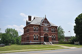
Troy is a census-designated place (CDP) and the main village in the town of Troy in Cheshire County, New Hampshire, United States. The population of the CDP was 1,108 at the 2020 census, compared to 2,130 in the entire town. The center of the CDP is the Troy Village Historic District.

<span class="mw-page-title-main">Walpole (CDP), New Hampshire</span> Census-designated place in New Hampshire, United States

Walpole is a census-designated place (CDP) and the central village in the town of Walpole in Cheshire County, New Hampshire, United States. The population of the CDP was 573 at the 2020 census, compared to 3,633 in the entire town.

References

  1. "ArcGIS REST Services Directory". United States Census Bureau. Retrieved September 20, 2022.
  2. "Winchester CDP, New Hampshire: 2020 DEC Redistricting Data (PL 94-171)". U.S. Census Bureau. Retrieved November 5, 2021.
  3. "TIGERweb: Winchester CDP, New Hampshire". Geography Division, U.S. Census Bureau. Retrieved August 29, 2017.
  4. "2021 U.S. Gazetteer Files – New Hampshire". United States Census Bureau. Retrieved November 5, 2021.
  5. "Decennial Census Official Publications". Census.gov. Retrieved March 4, 2024.
  6. 1 2 3 "Profile of General Population and Housing Characteristics: 2010 Census Summary File 1 (DP-1): Winchester CDP, New Hampshire". U.S. Census Bureau, American Factfinder. Archived from the original on February 13, 2020. Retrieved August 29, 2017.
  7. "Selected Economic Characteristics: 2011-2015 American Community Survey 5-Year Estimates (DP03): Winchester CDP, New Hampshire". U.S. Census Bureau, American Factfinder. Archived from the original on February 13, 2020. Retrieved August 29, 2017.