Gilsum, New Hampshire

Last updated
Gilsum, New Hampshire
Town
Bird's-eye View of Gilsum, NH.jpg
Bird's-eye view in 1908
Cheshire-Gilsum-NH.png
Coordinates: 43°02′54″N72°15′46″W / 43.04833°N 72.26278°W / 43.04833; -72.26278
Country United States
State New Hampshire
County Cheshire
Incorporated 1763
Villages
  • Gilsum
  • Lower Village
Government
   Board of Selectmen
  • Bart Cushing, Chair
  • Clem Lounder
  • Sally Struble
Area
[1]
  Total16.69 sq mi (43.23 km2)
  Land16.67 sq mi (43.17 km2)
  Water0.02 sq mi (0.06 km2)  0.13%
Elevation
873 ft (266 m)
Population
 (2020) [2]
  Total752
  Density45/sq mi (17.4/km2)
Time zone UTC-5 (Eastern)
  Summer (DST) UTC-4 (Eastern)
ZIP code
03448
Area code 603
FIPS code 33-29220
GNIS feature ID0873605
Website gilsum-nh.gov

Gilsum is a town in Cheshire County, New Hampshire, United States. The population was 752 at the 2020 census. [2] Home to Bear's Den Natural Area, Gilsum includes Gilsum Lower Village.

Contents

History

The land was originally named "Boyle" after Richard Boyle, Earl of Burlington, when the land was granted by the Masonian Proprietors in 1752, but ongoing hostilities during the French and Indian War prevented settlement. When the grant lapsed, the town was rechartered by Governor Benning Wentworth on July 13, 1763, as Gilsum, combining the surnames of two proprietors, Samuel Gilbert and his son-in-law, Thomas Sumner. It was first settled in 1764 by Josiah Kilburn from Hebron, Connecticut. [3]

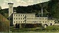
The Ashuelot River provided water power for woolen mills. By 1859, when the population was 668, there was also a bobbin factory, a chair factory, and a tannery. Gilsum used to be a center for mining mica and feldspar. High-quality crystals, especially beryl, tourmaline, and quartz, can also be found. [4] Today, Gilsum is headquarters to the W.S. Badger Company, makers of "balms, potions and natural remedies."

The town contains the Stone Arch Bridge, completed in 1863 with the highest vault (36 feet, 6 inches) of any mortarless bridge in New Hampshire. In 1989, it was added to the National Register.

Geography

According to the United States Census Bureau, the town has a total area of 16.7 square miles (43.2 km2), of which 0.02 square miles (0.06 km2) are water, comprising 0.13% of the town. [1] The highest point in Gilsum is an unnamed hill along the town's eastern boundary, where the elevation reaches 1,657 feet (505 m) above sea level. Gilsum is drained by the Ashuelot River and lies fully within the Connecticut River watershed. [5]

The town is served by New Hampshire Route 10.

Adjacent municipalities

Demographics

Historical population
CensusPop.Note
1790 298
1800 48462.4%
1810 5136.0%
1820 60117.2%
1830 412−31.4%
1840 65659.2%
1850 6681.8%
1860 6761.2%
1870 590−12.7%
1880 66312.4%
1890 643−3.0%
1900 590−8.2%
1910 470−20.3%
1920 439−6.6%
1930 50615.3%
1940 491−3.0%
1950 57817.7%
1960 528−8.7%
1970 5708.0%
1980 65214.4%
1990 74514.3%
2000 7774.3%
2010 8134.6%
2020 752−7.5%
U.S. Decennial Census [2] [6]

As of the census [7] of 2000, there were 777 people, 310 households, and 220 families residing in the town. The population density was 46.6 inhabitants per square mile (18.0/km2). There were 343 housing units at an average density of 20.6 per square mile (7.9/km2). The racial makeup of the town was 98.46% White, 0.39% Native American, 0.13% Asian, and 1.03% from two or more races. Hispanic or Latino of any race were 0.51% of the population.

There were 310 households, out of which 26.5% had children under the age of 18 living with them, 58.7% were married couples living together, 8.7% had a female householder with no husband present, and 29.0% were non-families. 23.9% of all households were made up of individuals, and 6.5% had someone living alone who was 65 years of age or older. The average household size was 2.48 and the average family size was 2.90.

In the town, the population was spread out, with 22.3% under the age of 18, 5.0% from 18 to 24, 30.0% from 25 to 44, 31.9% from 45 to 64, and 10.8% who were 65 years of age or older. The median age was 41 years. For every 100 females, there were 98.2 males. For every 100 females age 18 and over, there were 104.1 males.

The median income for a household in the town was $43,359, and the median income for a family was $50,469. Males had a median income of $35,150 versus $24,205 for females. The per capita income for the town was $20,955. About 1.9% of families and 7.0% of the population were below the poverty line, including 1.3% of those under age 18 and 13.7% of those age 65 or over.

Sites of interest

Notable people

Related Research Articles

<span class="mw-page-title-main">Barnstead, New Hampshire</span> Town in New Hampshire, United States

Barnstead is a town in Belknap County, New Hampshire, United States. The population was 4,915 at the 2020 census, up from 4,593 at the 2010 census. Home to the Suncook Lakes, Barnstead includes the villages of Center Barnstead, Barnstead Parade and South Barnstead.

<span class="mw-page-title-main">Effingham, New Hampshire</span> Town in New Hampshire, United States

Effingham is a town in Carroll County, New Hampshire, United States. At the 2020 census, the town population was 1,691, up from 1,465 at the 2010 census. Effingham includes the villages of Effingham Falls, Effingham, Center Effingham, and South Effingham. Pine River State Forest is in the south.

<span class="mw-page-title-main">Fitzwilliam, New Hampshire</span> Town in New Hampshire, United States

Fitzwilliam is a town in Cheshire County, New Hampshire, United States. The population was 2,351 at the 2020 census. Fitzwilliam is home to Rhododendron State Park, a 16-acre (6.5 ha) grove of native rhododendrons that bloom in mid-July.

<span class="mw-page-title-main">Marlow, New Hampshire</span> Town in New Hampshire, United States

Marlow is a town in Cheshire County, New Hampshire, United States. The population was 749 at the 2020 census. Marlow is home to Honey Brook State Forest.

<span class="mw-page-title-main">Stoddard, New Hampshire</span> Town in New Hampshire, United States

Stoddard is a town in Cheshire County, New Hampshire, United States. The population was 1,374 at the 2020 census, up from 1,232 at the 2010 census.

<span class="mw-page-title-main">Sullivan, New Hampshire</span> Town in New Hampshire, United States

Sullivan is a town in Cheshire County, New Hampshire, United States. The population was 658 at the 2020 census. It includes the villages of East Sullivan and Ellisville.

<span class="mw-page-title-main">Surry, New Hampshire</span> Town in New Hampshire, United States

Surry is a town in Cheshire County, New Hampshire, United States. The population was 820 at the 2020 census, up from 732 at the 2010 census.

<span class="mw-page-title-main">Swanzey, New Hampshire</span> Town in New Hampshire, United States

Swanzey is a town in Cheshire County, New Hampshire, United States. The population was 7,270 at the 2020 census. In addition to the town center, Swanzey includes the villages of East Swanzey, West Swanzey, North Swanzey and Westport.

<span class="mw-page-title-main">Troy, New Hampshire</span> Town in New Hampshire, United States

Troy is a town in Cheshire County, New Hampshire, United States. The population was 2,130 at the 2020 census. It is situated west of Mount Monadnock.

<span class="mw-page-title-main">Columbia, New Hampshire</span> Town in New Hampshire, United States

Columbia is a town in Coös County, New Hampshire, United States. The population was 659 at the 2020 census, down from 757 at the 2010 census. It is part of the Berlin, NH–VT micropolitan statistical area.

<span class="mw-page-title-main">Northumberland, New Hampshire</span> Town in New Hampshire, United States

Northumberland is a town located in western Coös County, New Hampshire, U.S., north of Lancaster. It is part of the Berlin, NH–VT micropolitan statistical area. As of the 2020 census, the town population was 2,126, of whom 1,068 lived in the village of Groveton.

<span class="mw-page-title-main">Greenfield, New Hampshire</span> Town in New Hampshire, United States

Greenfield is a town in Hillsborough County, New Hampshire, United States. The population was 1,716 at the 2020 census. Greenfield is home to the Crotched Mountain Rehabilitation Center, to Greenfield State Park, and to part of the Wapack Trail.

<span class="mw-page-title-main">Salisbury, New Hampshire</span> Town in New Hampshire, United States

Salisbury is a town in Merrimack County, New Hampshire, United States. The population was 1,422 at the 2020 census.

<span class="mw-page-title-main">Warner, New Hampshire</span> Town in New Hampshire, United States

Warner is a town in Merrimack County, New Hampshire, United States. The population was 2,937 at the 2020 census. The town is home to Magdalen College of the Liberal Arts, Rollins State Park and Mount Kearsarge State Forest.

<span class="mw-page-title-main">Langdon, New Hampshire</span> Place in New Hampshire, United States

Langdon is a town in Sullivan County, New Hampshire, United States. The population was 651 at the 2020 census.

<span class="mw-page-title-main">Lempster, New Hampshire</span> Place in New Hampshire, United States

Lempster is a town in Sullivan County, New Hampshire, United States. The population was 1,118 at the 2020 census. Settlements include the town center and the village of East Lempster.

<span class="mw-page-title-main">Jaffrey, New Hampshire</span> Town in New Hampshire, United States

Jaffrey is a town in Cheshire County, New Hampshire, United States. The population was 5,320 at the 2020 census.

<span class="mw-page-title-main">Marlborough, New Hampshire</span> Town in New Hampshire, United States

Marlborough is a town in Cheshire County, New Hampshire, United States. The population was 2,096 at the 2020 census. The town is home to the Kensan-Devan Wildlife Sanctuary at Meetinghouse Pond.

<span class="mw-page-title-main">Winchester, New Hampshire</span> Town in New Hampshire, United States

Winchester is a town in Cheshire County, New Hampshire, United States. The population was 4,150 at the 2020 census. The primary community in the town, where 1,606 people resided at the 2020 census, is defined by the U.S. Census Bureau as the Winchester census-designated place (CDP). The town also includes the village of Ashuelot and part of Pisgah State Park.

<span class="mw-page-title-main">Wilton, New Hampshire</span> Town in New Hampshire, United States

Wilton is a town in Hillsborough County, New Hampshire, United States. The population was 3,896 at the 2020 census. Like many small New England towns, it grew up around water-powered textile mills, but is now a rural bedroom community with some manufacturing and service employment. Wilton is home to the High Mowing School, a private preparatory school.

References

  1. 1 2 "2021 U.S. Gazetteer Files – New Hampshire". United States Census Bureau. Retrieved November 3, 2021.
  2. 1 2 3 "Gilsum town, Cheshire County, New Hampshire: 2020 DEC Redistricting Data (PL 94-171)". U.S. Census Bureau. Retrieved November 3, 2021.
  3. Coolidge, Austin J.; John B. Mansfield (1859). A History and Description of New England. Boston, Massachusetts: A.J. Coolidge. p.  502. coolidge mansfield history description new england 1859.
  4. History of Gilsum, New Hampshire
  5. Foster, Debra H.; Batorfalvy, Tatianna N.; Medalie, Laura (1995). Water Use in New Hampshire: An Activities Guide for Teachers. U.S. Department of the Interior and U.S. Geological Survey.
  6. "Census of Population and Housing". Census.gov. Retrieved June 4, 2016.
  7. "U.S. Census website". United States Census Bureau . Retrieved 2008-01-31.