Westmoreland, New Hampshire

Last updated

Westmoreland, New Hampshire
Town
Union Church, East Westmoreland, NH.jpg
Union Church c.1915
Cheshire-Westmoreland-NH.png
Coordinates: 42°57′43″N72°26′32″W / 42.96194°N 72.44222°W / 42.96194; -72.44222
Country United States
State New Hampshire
County Cheshire
Incorporated 1752
Villages
  • Westmoreland
  • East Westmoreland
  • Park Hill
  • Poocham
Government
   Board of Selectmen
  • Frank Reeder, Chair
  • John Snowdon
  • Bill McGahie
  Town AdministratorJodi Scanlan
Area
[1]
  Total36.8 sq mi (95.4 km2)
  Land35.8 sq mi (92.7 km2)
  Water1.0 sq mi (2.7 km2)  2.80%
Elevation
417 ft (127 m)
Population
 (2020) [2]
  Total1,706
  Density48/sq mi (18.4/km2)
Time zone UTC-5 (Eastern)
  Summer (DST) UTC-4 (Eastern)
ZIP code
03467
Area code 603
FIPS code 33-82660
GNIS feature ID0873753
Website www.westmorelandnh.com

Westmoreland is a town in Cheshire County, New Hampshire, United States. The population was 1,706 at the 2020 census, [2] down from 1,874 at the 2010 census. [3] Westmoreland is historically an agricultural town, with much arable farmland.

Contents

History

Indigenous peoples

Prior to European colonization, present-day Westmoreland was inhabited by numerous indigenous tribes. The upper Connecticut River valley was a popular region for short-term Indigenous villages mostly used for hunting and fishing. [4] Tribes such as the Pennacook Confederation and the Abenaki were frequent visitors to the area. In the 1670s, King Philip's War led to the migration of most indigenous tribes to Canada. [4] Indigenous peoples did not understand the concept of individual land ownership, which resulted in numerous misunderstandings and conflict between them and English settlers. [4] The English settlers purchase of land and construction of permanent settlements disrupted the hunting and fishing traditions of the indigenous tribes.

While Indigenous activity was common in Westmoreland, not many aboriginal sites have been found. A "Pow-wow Rock" can be located off Poocham Road in Westmoreland across from the Thompson place (1970). [4] The name Poocham is an Abenaki word for "gathering place". [5] The Pow-wow Rock is a large boulder that was deposited by glaciers and is measured at 12 by 14 by 8 feet (3.7 by 4.3 by 2.4 m) in height. At this location, records describe the hosting of Indigenous pow-wows and the exchanging of prisoners. [5]
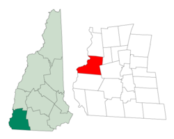
Colonial

Once known as "Great Meadow", the town was first granted in 1735 by Governor Jonathan Belcher of Massachusetts as "Number 2", second in a line of Connecticut River fort towns designed to protect the colonies from Indian attack. This part of the river was a favorite Indian campsite, and the settlers who came beginning in 1741 were several times victims of attack. When the border between Massachusetts and the Province of New Hampshire was fixed (with Number 2 on the New Hampshire side), the town was regranted in 1752 by Governor Benning Wentworth as Westmoreland, named for John Fane, 7th Earl of Westmorland. [6]

The Park Hill Meetinghouse, built in 1762, has a Paul Revere bell. Considered one of the most beautiful churches in New England, it was moved to its present site by oxen in 1779 and renovated in 1826. [7]

Geography

According to the United States Census Bureau, the town has a total area of 36.8 square miles (95.4 km2), of which 35.8 square miles (92.7 km2) is land and 1.0 square mile (2.7 km2), or 2.80%, is water. Westmoreland is bounded on the west by the Connecticut River, which is the state border with Vermont. Hyland Hill, elevation 1,510 feet (460 m) and the highest point in town, is on the eastern border and although it is now private land, it is a local hiking and hunting destination.

Westmoreland is served by state routes 12 and 63.

Adjacent municipalities

Demographics

Historical population
CensusPop.Note
1790 2,018
1800 2,0662.4%
1810 1,937−6.2%
1820 2,0294.7%
1830 1,647−18.8%
1840 1,546−6.1%
1850 1,6788.5%
1860 1,285−23.4%
1870 1,256−2.3%
1880 1,095−12.8%
1890 830−24.2%
1900 8755.4%
1910 758−13.4%
1920 615−18.9%
1930 74521.1%
1940 7551.3%
1950 7894.5%
1960 92116.7%
1970 9988.4%
1980 1,45245.5%
1990 1,5969.9%
2000 1,7479.5%
2010 1,8747.3%
2020 1,706−9.0%
U.S. Decennial Census [8]

At the 2000 census there were 1,747 people, 576 households, and 445 families living in the town. The population density was 48.7 inhabitants per square mile (18.8/km2). There were 618 housing units at an average density of 17.2 per square mile (6.7/km2). The racial makeup of the town was 97.82% White, 0.34% African American, 0.29% Native American, 0.80% Asian, 0.34% from other races, and 0.40% from two or more races. Hispanic or Latino of any race were 0.92%. [9]

Of the 576 households 31.6% had children under the age of 18 living with them, 69.6% were married couples living together, 3.8% had a female householder with no husband present, and 22.7% were non-families. 17.4% of households were one person and 7.8% were one person aged 65 or older. The average household size was 2.57 and the average family size was 2.92.

The age distribution was 19.9% under the age of 18, 6.6% from 18 to 24, 26.8% from 25 to 44, 27.4% from 45 to 64, and 19.3% 65 or older. The median age was 43 years. For every 100 females, there were 97.6 males. For every 100 females age 18 and over, there were 99.6 males.

The median household income was $55,875 and the median family income was $62,857. Males had a median income of $40,515 versus $28,456 for females. The per capita income for the town was $24,488. About 0.4% of families and 2.5% of the population were below the poverty line, including none of those under age 18 and 5.4% of those age 65 or over.

Notable people

Related Research Articles

<span class="mw-page-title-main">Cheshire County, New Hampshire</span> County in New Hampshire, United States

Cheshire County is a county in the southwestern corner of the U.S. state of New Hampshire. As of the 2020 census, the population was 76,458. Its county seat is the city of Keene. Cheshire was one of the five original counties of New Hampshire, and is named for the county of Cheshire in England. It was organized in 1771 at Keene. Sullivan County was created from the northern portion of Cheshire County in 1827.

<span class="mw-page-title-main">Brownfield, Maine</span> Town in the state of Maine, United States

Brownfield is a town in Oxford County, Maine, United States. The population was 1,631 at the 2020 census. Brownfield is home to the Stone Mountain Arts Center.

<span class="mw-page-title-main">Canton, Maine</span> Town in the state of Maine, United States

Canton is a town in Oxford County, Maine, United States. The population was 1,125 at the 2020 census. Located beside Lake Anasagunticook, Canton is a summer recreational area.

<span class="mw-page-title-main">Alstead, New Hampshire</span> Town in New Hampshire, United States

Alstead is a town in Cheshire County, New Hampshire, United States. The population was 1,864 at the 2020 census. Alstead is home to Feuer State Forest.

<span class="mw-page-title-main">Chesterfield, New Hampshire</span> Town in New Hampshire, United States

Chesterfield is a town in Cheshire County, New Hampshire, United States. The population was 3,552 at the 2020 census. It includes the villages of Spofford and West Chesterfield. Chesterfield is home to Spofford Lake, Chesterfield Gorge Natural Area, and parts of Pisgah State Park and Wantastiquet Mountain State Forest.

<span class="mw-page-title-main">Fitzwilliam, New Hampshire</span> Town in New Hampshire, United States

Fitzwilliam is a town in Cheshire County, New Hampshire, United States. The population was 2,351 at the 2020 census. Fitzwilliam is home to Rhododendron State Park, a 16-acre (6.5 ha) grove of native rhododendrons that bloom in mid-July.

<span class="mw-page-title-main">Richmond, New Hampshire</span> Town in New Hampshire, United States

Richmond is a town in Cheshire County, New Hampshire, United States. The population was 1,197 at the 2020 census.

<span class="mw-page-title-main">Rindge, New Hampshire</span> Town in New Hampshire, United States

Rindge is a town in Cheshire County, New Hampshire, United States. The population was 6,476 at the 2020 census, up from 6,014 at the 2010 census. Rindge is home to Franklin Pierce University, the Cathedral of the Pines and part of Annett State Forest.

<span class="mw-page-title-main">Sullivan, New Hampshire</span> Town in New Hampshire, United States

Sullivan is a town in Cheshire County, New Hampshire, United States. The population was 658 at the 2020 census. It includes the villages of East Sullivan and Ellisville.

<span class="mw-page-title-main">Surry, New Hampshire</span> Town in New Hampshire, United States

Surry is a town in Cheshire County, New Hampshire, United States. The population was 820 at the 2020 census, up from 732 at the 2010 census.

<span class="mw-page-title-main">Walpole, New Hampshire</span> Town in New Hampshire, United States

Walpole is a town in Cheshire County, New Hampshire, United States. The population was 3,633 at the 2020 census.

<span class="mw-page-title-main">Haverhill, New Hampshire</span> Town in New Hampshire, United States

Haverhill is a town in Grafton County, New Hampshire, United States. The population was 4,585 at the 2020 census. Haverhill includes the villages of Woodsville, Pike, and North Haverhill, the historic town center at Haverhill Corner, and the district of Mountain Lakes. Located here are Bedell Bridge State Park, Black Mountain State Forest, Kinder Memorial Forest, and Oliverian Valley Wildlife Preserve. It is home to the annual North Haverhill Fair, and to a branch of the New Hampshire Community Technical Colleges. The village of North Haverhill is the county seat of Grafton County.

<span class="mw-page-title-main">Salisbury, New Hampshire</span> Town in New Hampshire, United States

Salisbury is a town in Merrimack County, New Hampshire, United States. The population was 1,422 at the 2020 census.

<span class="mw-page-title-main">Cornish, New Hampshire</span> Town in New Hampshire, United States

Cornish is a town in Sullivan County, New Hampshire, United States. The population was 1,616 at the 2020 census. Cornish has four covered bridges. Each August, it is home to the Cornish Fair.

<span class="mw-page-title-main">Reading, Vermont</span> Town in Vermont, United States

Reading is a town in Windsor County, Vermont, United States. The population was 687 at the 2020 census.

<span class="mw-page-title-main">Weston, Vermont</span> Town in Vermont, United States

Weston is a town in Windsor County, Vermont, United States. The population was 623 at the 2020 census. Home to the Weston Playhouse Theatre Company, it includes the villages of Weston and The Island.

<span class="mw-page-title-main">Hinsdale, New Hampshire</span> Town in New Hampshire, United States

Hinsdale is a town in Cheshire County, New Hampshire, United States. The population was 3,948 at the 2020 census. Hinsdale is home to part of Pisgah State Park in the northeast, and part of Wantastiquet Mountain State Forest in the northwest.

<span class="mw-page-title-main">Marlborough, New Hampshire</span> Town in New Hampshire, United States

Marlborough is a town in Cheshire County, New Hampshire, United States. The population was 2,096 at the 2020 census. The town is home to the Kensan-Devan Wildlife Sanctuary at Meetinghouse Pond.

<span class="mw-page-title-main">Swanton, Vermont (town)</span> Town in Vermont, United States

Swanton is a town in Franklin County, Vermont, United States. The population was 6,701 at the 2020 census. The town includes the village of Swanton.

<span class="mw-page-title-main">Newbury (town), Vermont</span> Town in Vermont, United States

Newbury is a town in Orange County, Vermont, United States. The population was 2,293 at the 2020 census. Newbury includes the villages of Newbury, Center Newbury, West Newbury, South Newbury, Boltonville, Peach Four Corners, and Wells River.

References

  1. "2021 U.S. Gazetteer Files – New Hampshire". United States Census Bureau. Retrieved November 5, 2021.
  2. 1 2 "Westmoreland town, Cheshire County, New Hampshire: 2020 DEC Redistricting Data (PL 94-171)". U.S. Census Bureau. Retrieved November 5, 2021.
  3. United States Census Bureau, American FactFinder, 2010 Census figures. Retrieved March 23, 2011.
  4. 1 2 3 4 History of Westmoreland (Great Meadow) New Hampshire: 1741-1970, and Genealogical Data. Westmoreland History Committee. 1976.
  5. 1 2 Austin, Carol (November 18, 2014). "A Westmoreland home with history". Keene Sentinel. Retrieved December 14, 2021.
  6. Coolidge, Austin J.; John B. Mansfield (1859). A History and Description of New England. Boston, Massachusetts: A.J. Coolidge. p.  677. coolidge mansfield history description new england 1859.
  7. History of Westmoreland, Cheshire County, New Hampshire
  8. "Census of Population and Housing". Census.gov. Retrieved June 4, 2016.
  9. "U.S. Census website". United States Census Bureau . Retrieved January 31, 2008.