North Walpole, New Hampshire

Last updated

North Walpole, New Hampshire
St Peters Roman Catholic Church, North Walpole NH.jpg
St. Peter's Roman Catholic Church
USA New Hampshire location map.svg
Red pog.svg
North Walpole
Usa edcp location map.svg
Red pog.svg
North Walpole
Coordinates: 43°8′20″N72°26′53″W / 43.13889°N 72.44806°W / 43.13889; -72.44806
Country United States
State New Hampshire
County Cheshire
Town Walpole
Area
[1]
  Total0.70 sq mi (1.81 km2)
  Land0.69 sq mi (1.80 km2)
  Water0.00 sq mi (0.01 km2)
Elevation
308 ft (94 m)
Population
 (2020)
  Total785
  Density1,131.12/sq mi (436.64/km2)
Time zone UTC-5 (Eastern (EST))
  Summer (DST) UTC-4 (EDT)
ZIP code
03609
Area code 603
FIPS code 33-56420
GNIS feature ID0868821

North Walpole is a census-designated place (CDP) in the town of Walpole in Cheshire County, New Hampshire, United States. It had a population of 785 at the 2020 census, [2] making it the largest village in the town of Walpole.

Contents

It is located along New Hampshire Route 12 directly across the Connecticut River from the village of Bellows Falls, Vermont. North Walpole has a separate ZIP code (03609) from the rest of Walpole.

History

Spring snowmelt brought log drives down the Connecticut River. Log drivers were stationed to guide logs through a sluice over the dam at Bellows Falls. North Walpole offered twelve to eighteen saloons to quench log drivers' thirst. [3] These spring drives were stopped after 1915, when pleasure boat owners complained about the hazards to navigation. [4]

Geography

North Walpole is in the northwestern corner of the town of Walpole, bordered to the south and west by the Connecticut River and to the north by the town of Charlestown in Sullivan County. New Hampshire Route 12 passes through the center of the village as Main Street and Church Street; it leads north 7 miles (11 km) to Charlestown and 20 miles (32 km) to Claremont, while to the south it leads 4.5 miles (7.2 km) to Walpole village and 21 miles (34 km) to Keene. The Arch Bridge leads from North Walpole across the Connecticut River to the village of Bellows Falls in Vermont.

According to the U.S. Census Bureau, the North Walpole CDP has a total area of 0.7 square miles (1.8 km2), of which 2.24 acres (9,081 m2), or 0.51%, are water. [5]

Demographics

Historical population
CensusPop.Note
2010 828
2020 785−5.2%
U.S. Decennial Census [6]

As of the census of 2010, there were 828 people, 340 households, and 216 families residing in the CDP. There were 387 housing units, of which 47, or 12.1%, were vacant. The racial makeup of the CDP was 96.3% white, 0.4% African American, 0.2% Native American, 0.2% Asian, 0.0% Native Hawaiian or Pacific Islander, 0.4% some other race, and 2.5% two or more races. 1.4% of the population were Hispanic or Latino of any race. [7]

Of the 340 households in the CDP, 35.0% had children under the age of 18 living with them, 43.2% were headed by married couples living together, 14.1% had a female householder with no husband present, and 36.5% were non-families. 30.0% of all households were made up of individuals, and 10.5% were someone living alone who was 65 years of age or older. The average household size was 2.44, and the average family size was 3.02. [7]

26.3% of residents in the CDP were under the age of 18, 7.0% were from age 18 to 24, 29.9% were from 25 to 44, 24.0% were from 45 to 64, and 12.7% were 65 years of age or older. The median age was 37.4 years. For every 100 females, there were 92.6 males. For every 100 females age 18 and over, there were 90.6 males. [7]

For the period 2011-15, the estimated median annual income for a household was $71,739, and the median income for a family was $70,583. The per capita income for the CDP was $26,565. 8.9% of the population and 4.7% of families were below the poverty line, along with 9.1% of people under the age of 18 and 6.3% of people 65 or older. [8]

Notable person

Related Research Articles

<span class="mw-page-title-main">Walpole, New Hampshire</span> Town in New Hampshire, United States

Walpole is a town in Cheshire County, New Hampshire, United States. The population was 3,633 at the 2020 census.

<span class="mw-page-title-main">Groveton, New Hampshire</span> Census-designated place in New Hampshire, United States

Groveton is a census-designated place (CDP) and the primary village in the town of Northumberland in Coos County, New Hampshire, United States. The population was 1,068 at the 2020 census. It is located at the intersection of U.S. Route 3 and New Hampshire Route 110.

<span class="mw-page-title-main">Woodsville, New Hampshire</span> Census-designated place in New Hampshire, United States

Woodsville is a census-designated place (CDP) and the largest village in the town of Haverhill in Grafton County, New Hampshire, United States, along the Connecticut River at the mouth of the Ammonoosuc River. The population was 1,431 at the 2020 census. Although North Haverhill is now the county seat of Grafton County, the village of Woodsville has traditionally been considered the county seat, as the county courthouse was originally located there. The county buildings are now located halfway between Woodsville and the village of North Haverhill to the south.

<span class="mw-page-title-main">Unity, New Hampshire</span> Place in New Hampshire, United States

Unity is a town in Sullivan County, New Hampshire, United States. The population was 1,518 at the 2020 census, down from 1,671 at the 2010 census. The town includes the villages of Unity, East Unity, Quaker City, and West Unity.

<span class="mw-page-title-main">Bloomfield, Vermont</span> Town in Vermont, United States

Bloomfield is a town in Essex County, Vermont, United States. The population was 217 at the 2020 census. It is part of the Berlin, New Hampshire-Vermont Micropolitan Statistical Area.

<span class="mw-page-title-main">Hinsdale (CDP), New Hampshire</span> Census-designated place in New Hampshire, United States

Hinsdale is a census-designated place (CDP) and the main village in the town of Hinsdale in Cheshire County, New Hampshire, United States. The population of the CDP was 1,485 at the 2020 census, out of 3,948 in the entire town of Hinsdale.

<span class="mw-page-title-main">Winchester (CDP), New Hampshire</span> Census-designated place in New Hampshire, United States

Winchester is a census-designated place (CDP) and the main village in the town of Winchester in Cheshire County, New Hampshire, United States. The population of the CDP was 1,606 at the 2020 census, compared to 4,150 in the entire town.

Lancaster is a census-designated place (CDP) and the main village in the town of Lancaster in Coos County, New Hampshire, United States. The population of the CDP was 1,941 at the 2020 census, out of 3,218 in the entire town of Lancaster.

Whitefield is a census-designated place (CDP) and the main village in the town of Whitefield in Coos County, New Hampshire, United States. The population of the CDP was 1,460 at the 2020 census, out of 2,490 people in the entire town of Whitefield.

Hanover is a census-designated place (CDP) and the main village in the town of Hanover in Grafton County, New Hampshire, United States. The population of the CDP was 9,078 at the 2020 census, out of 11,870 in the entire town. The CDP includes the campus of Dartmouth College.

Littleton is a census-designated place (CDP) and the main village in the town of Littleton in Grafton County, New Hampshire, United States. The population of the CDP was 4,467 at the 2020 census, out of 6,005 in the entire town.

<span class="mw-page-title-main">Exeter (CDP), New Hampshire</span> Census-designated place in New Hampshire, United States

Exeter is a census-designated place (CDP) and the main village in the town of Exeter, Rockingham County, New Hampshire, United States. The population of the CDP was 10,109 at the 2020 census, out of 16,049 in the entire town.

<span class="mw-page-title-main">Charlestown (CDP), New Hampshire</span> Census-designated place in New Hampshire, United States

Charlestown is a census-designated place (CDP) and the main village in the town of Charlestown, Sullivan County, New Hampshire, United States. The population of the CDP was 1,078 at the 2020 census, out of 4,806 in the entire town.

<span class="mw-page-title-main">Charlestown, New Hampshire</span> Place in New Hampshire, United States

Charlestown is a town in Sullivan County, New Hampshire, United States. The population was 4,806 at the 2020 census, down from 5,114 at the 2010 census. The town is home to Hubbard State Forest and the headquarters of the Student Conservation Association.

<span class="mw-page-title-main">West Stewartstown, New Hampshire</span> Census-designated place in New Hampshire, United States

West Stewartstown is a census-designated place in the town of Stewartstown in Coös County, New Hampshire, United States. It had a population of 263 at the 2020 census, down from 386 at the 2010 census.

Milton is a census-designated place (CDP) and the primary village in the town of Milton, Strafford County, New Hampshire, United States. The population of the CDP was 593 at the 2020 census, out of 4,482 in the entire town.

Canaan is a census-designated place (CDP) and the main village in the town of Canaan in Grafton County, New Hampshire, United States. The population of the CDP was 442 at the 2020 census, out of 3,794 in the entire town.

<span class="mw-page-title-main">Colebrook (CDP), New Hampshire</span> Census-designated place in New Hampshire, United States

Colebrook is a census-designated place (CDP) and the main village in the town of Colebrook, Coös County, New Hampshire, United States. The population of the CDP was 1,201 at the 2020 census, out of 2,084 in the entire town. The CDP population had dropped from 1,394 at the 2010 census.

Plainfield is a census-designated place (CDP) and the namesake village in the town of Plainfield, Sullivan County, New Hampshire, United States. The population of the CDP was 178 at the 2020 census, out of 2,459 in the entire town.

<span class="mw-page-title-main">Walpole (CDP), New Hampshire</span> Census-designated place in New Hampshire, United States

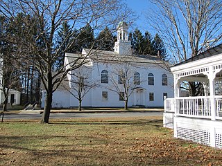
Walpole is a census-designated place (CDP) and the central village in the town of Walpole in Cheshire County, New Hampshire, United States. The population of the CDP was 573 at the 2020 census, compared to 3,633 in the entire town.

References

  1. "ArcGIS REST Services Directory". United States Census Bureau. Retrieved September 20, 2022.
  2. "North Walpole CDP, New Hampshire: 2020 DEC Redistricting Data (PL 94-171)". U.S. Census Bureau. Retrieved November 5, 2021.
  3. Holbrook, Stewart H. (1961). Yankee Loggers. International Paper Company. p. 70.
  4. Wheeler, Scott (September 2002). The History of Logging in Vermont's Northeast Kingdom. The Kingdom Historical.
  5. "2021 U.S. Gazetteer Files – New Hampshire". United States Census Bureau. Retrieved November 5, 2021.
  6. "Decennial Census Official Publications". Census.gov. Retrieved March 4, 2024.
  7. 1 2 3 "Profile of General Population and Housing Characteristics: 2010 Census Summary File 1 (DP-1): North Walpole CDP, New Hampshire". American Factfinder. U.S. Census Bureau. Archived from the original on February 13, 2020. Retrieved October 12, 2017.
  8. "Selected Economic Characteristics: 2011-2015 American Community Survey 5-Year Estimates (DP03): North Walpole CDP, New Hampshire". American Factfinder. U.S. Census Bureau. Archived from the original on February 13, 2020. Retrieved October 12, 2017.