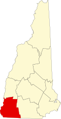
West Swanzey, New Hampshire

Last updated

West Swanzey, New Hampshire
Baptist Church, West Swanzey NH.jpg
Baptist Church at the village center
USA New Hampshire location map.svg
Red pog.svg
West Swanzey
Usa edcp location map.svg
Red pog.svg
West Swanzey
Coordinates: 42°52′11″N72°19′31″W / 42.86972°N 72.32528°W / 42.86972; -72.32528
Country United States
State New Hampshire
County Cheshire
Town Swanzey
Area
[1]
  Total2.60 sq mi (6.73 km2)
  Land2.58 sq mi (6.68 km2)
  Water0.02 sq mi (0.05 km2)
Elevation
512 ft (156 m)
Population
 (2020)
  Total1,281
  Density496.51/sq mi (191.69/km2)
Time zone UTC-5 (Eastern (EST))
  Summer (DST) UTC-4 (EDT)
ZIP code
03469
Area code 603
FIPS code 33-83700
GNIS feature ID0870797

West Swanzey is a census-designated place (CDP) in the town of Swanzey within Cheshire County, New Hampshire, United States. The population was 1,281 at the 2020 census. [2] It is the largest village in the town of Swanzey.

Contents

Geography

West Swanzey is located in the west-central part of the town of Swanzey, on both sides of the Ashuelot River. The West Swanzey Covered Bridge carries Main Street across the river in the center of the village. New Hampshire Route 10 passes through the west side of the village, leading north 6 miles (10 km) to Keene and south 7 miles (11 km) to Winchester.

According to the U.S. Census Bureau, the West Swanzey CDP has a total area of 2.60 square miles (6.73 km2), of which 2.58 square miles (6.68 km2) are land and 0.02 square miles (0.05 km2), or 0.70%, are water. [3]

Demographics

Historical population
CensusPop.Note
1980 1,022
1990 1,0553.2%
2000 1,1186.0%
2010 1,30817.0%
2020 1,281−2.1%
U.S. Decennial Census [4]

As of the census of 2010, there were 1,308 people, 581 households, and 340 families residing in the CDP. There were 617 housing units, of which 36, or 5.8%, were vacant. The racial makeup of the CDP was 93.2% white, 0.8% African American, 0.2% Native American, 4.4% Asian, 0.0% Native Hawaiian or Pacific Islander, 0.2% some other race, and 1.2% two or more races. 1.2% of the population were Hispanic or Latino of any race. [5]

Of the 581 households in the CDP, 29.1% had children under the age of 18 living with them, 39.4% were headed by married couples living together, 13.3% had a female householder with no husband present, and 41.5% were non-families. 30.3% of all households were made up of individuals, and 10.2% were someone living alone who was 65 years of age or older. The average household size was 2.25, and the average family size was 2.83. [5]

21.5% of residents in the CDP were under the age of 18, 8.9% were from age 18 to 24, 28.3% were from 25 to 44, 26.6% were from 45 to 64, and 14.6% were 65 years of age or older. The median age was 37.9 years. For every 100 females, there were 86.1 males. For every 100 females age 18 and over, there were 86.1 males. [5]

For the period 2011–15, the estimated median annual income for a household was $38,856. Male full-time workers had a median income of 29,524 versus $27,738 for females. The per capita income for the CDP was $23,011. 40.2% of the population and 39.1% of families were below the poverty line, along with 83.1% of people under the age of 18 and 13.5% of people 65 or older. [6]

Related Research Articles

<span class="mw-page-title-main">Swanzey, New Hampshire</span> Town in New Hampshire, United States

Swanzey is a town in Cheshire County, New Hampshire, United States. The population was 7,270 at the 2020 census. In addition to the town center, Swanzey includes the villages of East Swanzey, West Swanzey, North Swanzey and Westport.

<span class="mw-page-title-main">Troy, New Hampshire</span> Town in New Hampshire, United States

Troy is a town in Cheshire County, New Hampshire, United States. The population was 2,130 at the 2020 census. It is situated west of Mount Monadnock.

<span class="mw-page-title-main">East Merrimack, New Hampshire</span> Census-designated place in New Hampshire, United States

East Merrimack is a census-designated place (CDP) in the town of Merrimack, Hillsborough County, New Hampshire, United States. There is no village center named "East Merrimack"; rather, the CDP refers to the region of the town of Merrimack lying east of the F. E. Everett Turnpike, overlapping portions of the villages of Reeds Ferry, Thornton's Ferry, and the center of Merrimack. The population was 5,176 at the 2020 census, up from 4,197 at the 2010 census.

<span class="mw-page-title-main">Pinardville, New Hampshire</span> Census-designated place in New Hampshire, United States

Pinardville is a census-designated place (CDP) in the town of Goffstown, Hillsborough County, New Hampshire, United States. It is a suburban neighborhood adjacent to the city of Manchester. The population was 5,034 at the 2020 census. Pinardville has existed since 1906.

<span class="mw-page-title-main">Suncook, New Hampshire</span> Census-designated place in New Hampshire, United States

Suncook is a census-designated place (CDP) in Merrimack County, New Hampshire, United States. The population was 5,501 at the 2020 census. Approximately two-thirds of Suncook is located in the town of Pembroke, with the remainder in Allenstown.

<span class="mw-page-title-main">Tilton Northfield, New Hampshire</span> Census-designated place in New Hampshire, United States

Tilton Northfield is a census-designated place (CDP) representing two adjacent villages in the towns of Tilton in Belknap County and Northfield in Merrimack County in the U.S. state of New Hampshire. The CDP encompasses the town centers of both Tilton and Northfield, located on either side of the Winnipesaukee River. The population was 3,324 at the 2020 census.

<span class="mw-page-title-main">Marlborough (CDP), New Hampshire</span> Census-designated place in New Hampshire, United States

Marlborough is a census-designated place (CDP) and the main village in the town of Marlborough in Cheshire County, New Hampshire, United States. The population of the CDP was 1,066 at the 2020 census, out of 2,096 in the entire town.

<span class="mw-page-title-main">Winchester (CDP), New Hampshire</span> Census-designated place in New Hampshire, United States

Winchester is a census-designated place (CDP) and the main village in the town of Winchester in Cheshire County, New Hampshire, United States. The population of the CDP was 1,606 at the 2020 census, compared to 4,150 in the entire town.

Gorham is a census-designated place (CDP) and the main village in the town of Gorham in Coos County, New Hampshire, United States. The population of the CDP was 1,851 at the 2020 census, out of 2,698 people in the entire town of Gorham.

Lancaster is a census-designated place (CDP) and the main village in the town of Lancaster in Coos County, New Hampshire, United States. The population of the CDP was 1,941 at the 2020 census, out of 3,218 in the entire town of Lancaster.

<span class="mw-page-title-main">Bristol (CDP), New Hampshire</span> Census-designated place in New Hampshire, United States

Bristol is a census-designated place (CDP) and the main village in the town of Bristol in Grafton County, New Hampshire, United States. The population of the CDP was 1,911 at the 2020 census, out of 3,244 in the entire town.

Enfield is a census-designated place (CDP) and the main village in the town of Enfield in Grafton County, New Hampshire, United States. The population of the CDP was 1,571 at the 2020 census, out of 4,465 in the entire town.

Hanover is a census-designated place (CDP) and the main village in the town of Hanover in Grafton County, New Hampshire, United States. The population of the CDP was 9,078 at the 2020 census, out of 11,870 in the entire town. The CDP includes the campus of Dartmouth College.

Littleton is a census-designated place (CDP) and the main village in the town of Littleton in Grafton County, New Hampshire, United States. The population of the CDP was 4,467 at the 2020 census, out of 6,005 in the entire town.

<span class="mw-page-title-main">Plymouth (CDP), New Hampshire</span> Census-designated place in New Hampshire, United States

Plymouth is a census-designated place (CDP) and the main village in the town of Plymouth in Grafton County, New Hampshire, United States. Its population was 4,730 at the 2020 census, out of 6,682 in the entire town. The CDP includes the campus of Plymouth State University.

<span class="mw-page-title-main">Milford (CDP), New Hampshire</span> Census-designated place in New Hampshire, United States

Milford is a census-designated place (CDP) and the main village in the town of Milford, Hillsborough County, New Hampshire, United States. The population of the CDP was 9,212 at the 2020 census, out of 16,131 in the entire town.

<span class="mw-page-title-main">Hampton (CDP), New Hampshire</span> Census-designated place in New Hampshire, United States

Hampton is a census-designated place (CDP) comprising the town center and surrounding developed areas of the town of Hampton, Rockingham County, New Hampshire, United States. The population of the CDP was 9,597 at the 2020 census, out of 16,214 in the entire town.

<span class="mw-page-title-main">West Stewartstown, New Hampshire</span> Census-designated place in New Hampshire, United States

West Stewartstown is a census-designated place in the town of Stewartstown in Coös County, New Hampshire, United States. It had a population of 263 at the 2020 census, down from 386 at the 2010 census.

<span class="mw-page-title-main">Amherst (CDP), New Hampshire</span> Census-designated place in New Hampshire, United States

Amherst is a census-designated place (CDP) and the main village in the town of Amherst in Hillsborough County, New Hampshire, United States. The population of the CDP was 697 at the 2020 census, out of 11,753 in the entire town. The village center is listed on the National Register of Historic Places as the Amherst Village Historic District.

<span class="mw-page-title-main">Colebrook (CDP), New Hampshire</span> Census-designated place in New Hampshire, United States

Colebrook is a census-designated place (CDP) and the main village in the town of Colebrook, Coös County, New Hampshire, United States. The population of the CDP was 1,201 at the 2020 census, out of 2,084 in the entire town. The CDP population had dropped from 1,394 at the 2010 census.

References

  1. "ArcGIS REST Services Directory". United States Census Bureau. Retrieved September 20, 2022.
  2. "West Swanzey CDP, New Hampshire: 2020 DEC Redistricting Data (PL 94-171)". U.S. Census Bureau. Retrieved November 5, 2021.
  3. "2021 U.S. Gazetteer Files – New Hampshire". United States Census Bureau. Retrieved November 5, 2021.
  4. "Decennial Census Official Publications". Census.gov. Retrieved March 4, 2024.
  5. 1 2 3 "Profile of General Population and Housing Characteristics: 2010 Census Summary File 1 (DP-1): West Swanzey CDP, New Hampshire". American Factfinder. U.S. Census Bureau. Archived from the original on February 13, 2020. Retrieved October 13, 2017.
  6. "Selected Economic Characteristics: 2011-2015 American Community Survey 5-Year Estimates (DP03): West Swanzey CDP, New Hampshire". American Factfinder. U.S. Census Bureau. Archived from the original on February 13, 2020. Retrieved October 13, 2017.