Surry, New Hampshire

Last updated

Surry, New Hampshire
Town
Town Hall, Surry NH.jpg
Town Hall
Surry Town Seal.png
Cheshire-Surry-NH.png
Coordinates: 43°01′04″N72°19′16″W / 43.01778°N 72.32111°W / 43.01778; -72.32111
Country United States
State New Hampshire
County Cheshire
Incorporated 1769
Communities
  • Surry
  • Shaws Corner
Government
   Board of Selectmen
  • Stevens Goldsmith
  • John Croteau III
  • Bruce Smith
Area
[1]
  Total16.0 sq mi (41.4 km2)
  Land15.7 sq mi (40.6 km2)
  Water0.3 sq mi (0.8 km2)  1.97%
Elevation
581 ft (177 m)
Population
 (2020) [2]
  Total820
  Density52/sq mi (20.2/km2)
Time zone UTC−5 (Eastern)
  Summer (DST) UTC−4 (Eastern)
ZIP Code
03431 (Keene)
Area code 603
FIPS code 33-75300
GNIS feature ID0873733
Website www.surry.nh.gov

Surry is a town in Cheshire County, New Hampshire, United States. The population was 820 at the 2020 census, [2] up from 732 at the 2010 census. [3]

Contents

History

Surry was chartered in 1769, and named for Charles Howard, Earl of Surrey.[ citation needed ] The first census taken in Surry, in 1790, reported 448 residents. [3]

Geography

According to the United States Census Bureau, the town has a total area of 16.0 square miles (41.4 km2), of which 15.7 square miles (40.6 km2) are land and 0.31 square miles (0.8 km2) is water, comprising 1.97% of the town. [1] The highest point in Surry is along the town's western border, on the upper slopes of Derry Hill, where the elevation reaches 1,555 feet (474 m).

Surry Dam on the Ashuelot River is in the south central part of town. It holds back Surry Mountain Lake, which functions as a recreational site.

A waterfall locally known as 40 Foot Falls can be seen from Joslin Road on Merriam Brook.

Adjacent municipalities

Demographics

Historical population
CensusPop.Note
1790 448
1800 56927.0%
1810 564−0.9%
1820 5701.1%
1830 539−5.4%
1840 481−10.8%
1850 55615.6%
1860 389−30.0%
1870 318−18.3%
1880 3262.5%
1890 270−17.2%
1900 250−7.4%
1910 213−14.8%
1920 200−6.1%
1930 198−1.0%
1940 23619.2%
1950 29123.3%
1960 36224.4%
1970 50740.1%
1980 65629.4%
1990 6671.7%
2000 6730.9%
2010 7328.8%
2020 82012.0%
U.S. Decennial Census [2] [4]

At the 2000 census there were 673 people, 268 households, and 206 families living in the town. The population density was 43.2 inhabitants per square mile (16.7/km2). There were 282 housing units at an average density of 18.1 per square mile (7.0/km2). The racial makeup of the town was 98.07% White, 0.59% Native American, 0.30% Asian, 0.15% from other races, and 0.89% from two or more races. Hispanic or Latino of any race were 1.49%. [5]

Of the 268 households 30.6% had children under the age of 18 living with them, 69.8% were married couples living together, 6.0% had a female householder with no husband present, and 22.8% were non-families. Of all households 18.7% were one person and 7.8% were one person aged 65 or older. The average household size was 2.51 and the average family size was 2.84.

The age distribution was 21.4% under the age of 18, 4.6% from 18 to 24, 26.4% from 25 to 44, 31.6% from 45 to 64, and 15.9% 65 or older. The median age was 44 years. For every 100 females, there were 96.8 males. For every 100 females age 18 and over, there were 98.9 males.

The median household income was $56,964 and the median family income was $60,179. Males had a median income of $34,464 versus $22,250 for females. The per capita income for the town was $24,277. About 0.5% of families and 1.8% of the population were below the poverty line, including 1.3% of those under age 18 and 4.9% of those age 65 or over.

Notable people

Related Research Articles

<span class="mw-page-title-main">Cheshire County, New Hampshire</span> County in New Hampshire, United States

Cheshire County is a county in the southwestern corner of the U.S. state of New Hampshire. As of the 2020 census, the population was 76,458. Its county seat is the city of Keene. Cheshire was one of the five original counties of New Hampshire, and is named for the county of Cheshire in England. It was organized in 1771 at Keene. Sullivan County was created from the northern portion of Cheshire County in 1827.

<span class="mw-page-title-main">Alstead, New Hampshire</span> Town in New Hampshire, United States

Alstead is a town in Cheshire County, New Hampshire, United States. The population was 1,864 at the 2020 census. Alstead is home to Feuer State Forest.

<span class="mw-page-title-main">Gilsum, New Hampshire</span> Town in New Hampshire, United States

Gilsum is a town in Cheshire County, New Hampshire, United States. The population was 752 at the 2020 census. Home to Bear's Den Natural Area, Gilsum includes Gilsum Lower Village.

<span class="mw-page-title-main">Harrisville, New Hampshire</span> Town in New Hampshire, United States

Harrisville is a town in Cheshire County, New Hampshire, United States. Besides the town center, it also includes the villages of Chesham and Eastview. The population of the town was 984 at the 2020 census.

<span class="mw-page-title-main">Richmond, New Hampshire</span> Town in New Hampshire, United States

Richmond is a town in Cheshire County, New Hampshire, United States. The population was 1,197 at the 2020 census.

<span class="mw-page-title-main">Roxbury, New Hampshire</span> Town in New Hampshire, United States

Roxbury is a town in Cheshire County, New Hampshire, United States. The population was 220 at the 2020 census.

<span class="mw-page-title-main">Sullivan, New Hampshire</span> Town in New Hampshire, United States

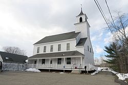
Sullivan is a town in Cheshire County, New Hampshire, United States. The population was 658 at the 2020 census. It includes the villages of East Sullivan and Ellisville.

<span class="mw-page-title-main">Swanzey, New Hampshire</span> Town in New Hampshire, United States

Swanzey is a town in Cheshire County, New Hampshire, United States. The population was 7,270 at the 2020 census. In addition to the town center, Swanzey includes the villages of East Swanzey, West Swanzey, North Swanzey and Westport.

<span class="mw-page-title-main">Troy, New Hampshire</span> Town in New Hampshire, United States

Troy is a town in Cheshire County, New Hampshire, United States. The population was 2,130 at the 2020 census. It is situated west of Mount Monadnock.

<span class="mw-page-title-main">Walpole, New Hampshire</span> Town in New Hampshire, United States

Walpole is a town in Cheshire County, New Hampshire, United States. The population was 3,633 at the 2020 census.

<span class="mw-page-title-main">West Swanzey, New Hampshire</span> Census-designated place in New Hampshire, United States

West Swanzey is a census-designated place (CDP) in the town of Swanzey within Cheshire County, New Hampshire, United States. The population was 1,281 at the 2020 census. It is the largest village in the town of Swanzey.

<span class="mw-page-title-main">Westmoreland, New Hampshire</span> Town in New Hampshire, United States

Westmoreland is a town in Cheshire County, New Hampshire, United States. The population was 1,706 at the 2020 census, down from 1,874 at the 2010 census. Westmoreland is historically an agricultural town, with much arable farmland.

<span class="mw-page-title-main">Stratford, New Hampshire</span> Town in New Hampshire, United States

Stratford is a town located on the Connecticut River in Coös County, New Hampshire, United States. The population was 662 at the 2020 census, down from 746 at the 2010 census. Within the town are the villages of North Stratford, Stratford Hollow, and Beatties. U.S. Route 3 passes through the center of town, as does the St. Lawrence and Atlantic Railroad, formerly a part of the Grand Trunk Railway.

<span class="mw-page-title-main">Windsor, New Hampshire</span> Town in New Hampshire, United States

Windsor is a town in Hillsborough County, New Hampshire, United States. The population was 262 at the 2020 census. It is the location of the Wediko Children's Services Summer Program and of Windsor Mountain International, a summer adventure and travel camp founded in 1961. It is also the home of Windsor Hills Camp and Retreat Center, a ministry of the Church of the Nazarene.

<span class="mw-page-title-main">Webster, New Hampshire</span> Town in New Hampshire, United States

Webster is a town in Merrimack County, New Hampshire, United States. The population was 1,913 at the 2020 census.

<span class="mw-page-title-main">Grantham, New Hampshire</span> Town in New Hampshire, United States

Grantham is a town in Sullivan County, New Hampshire, United States. The population was 3,404 at the 2020 census, up from 2,985 at the 2010 census. The planned community of Eastman is in the eastern part of the town.

<span class="mw-page-title-main">Springfield, New Hampshire</span> Place in New Hampshire, United States

Springfield is a town in Sullivan County, New Hampshire, United States. The population was 1,259 at the 2020 census. Gile State Forest is located within the town.

<span class="mw-page-title-main">Surry, Virginia</span> Town in Virginia, United States

Surry is an incorporated town in Surry County, Virginia, United States. The population was 244 at the 2010 census. It is the county seat of Surry County. Its name is derived from the historic county of Surrey in England.

<span class="mw-page-title-main">Hinsdale (CDP), New Hampshire</span> Census-designated place in New Hampshire, United States

Hinsdale is a census-designated place (CDP) and the main village in the town of Hinsdale in Cheshire County, New Hampshire, United States. The population of the CDP was 1,485 at the 2020 census, out of 3,948 in the entire town of Hinsdale.

<span class="mw-page-title-main">Jaffrey (CDP), New Hampshire</span> Census-designated place in New Hampshire, United States

Jaffrey is a census-designated place (CDP) and the main village in the town of Jaffrey in Cheshire County, New Hampshire, United States. The population of the CDP was 3,058 at the 2020 census, out of 5,320 in the entire town of Jaffrey.
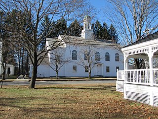
References

  1. 1 2 "2021 U.S. Gazetteer Files – New Hampshire". United States Census Bureau. Retrieved November 5, 2021.
  2. 1 2 3 "Surry town, Cheshire County, New Hampshire: 2020 DEC Redistricting Data (PL 94-171)". U.S. Census Bureau. Retrieved November 5, 2021.
  3. 1 2 United States Census Bureau, American FactFinder, 2010 Census figures. Retrieved March 23, 2011.
  4. "Census of Population and Housing". Census.gov. Retrieved June 4, 2016.
  5. "U.S. Census website". United States Census Bureau . Retrieved January 31, 2008.