Swanzey is a town in Cheshire County, New Hampshire, United States. The population was 7,270 at the 2020 census. In addition to the town center, Swanzey includes the villages of East Swanzey, West Swanzey, North Swanzey and Westport.

The Ashuelot River is a tributary of the Connecticut River, approximately 64 miles (103 km) long, in southwestern New Hampshire in the United States. It drains a mountainous area of 425 square miles (1,101 km2), including much of the area known as the Monadnock Region. It is the longest tributary of the Connecticut River within New Hampshire.
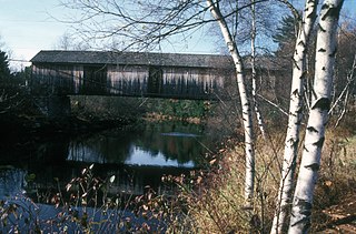
The Slate Covered Bridge is a wooden covered bridge which carries the Westport Village Road over the Ashuelot River in Westport, a village of Swanzey, New Hampshire. The bridge was built in 2001, as a replacement for an 1862 bridge that was destroyed by arson fire in 1993. The 1862 bridge, one of New Hampshire's small number of surviving 19th-century covered bridges, was listed on the National Register of Historic Places in 1978.

The Coombs Covered Bridge is a wooden covered bridge which carries Coombs Bridge Road over the Ashuelot River in northern Winchester, New Hampshire. It was built in 1843, and is one of the state's small number of surviving 19th-century covered bridges. It was listed on the National Register of Historic Places in 1976.

The Carlton Bridge is a historic wooden covered bridge that carries Carlton Road over the South Branch Ashuelot River in East Swanzey, New Hampshire. The bridge was built in 1869, and is the region's only surviving example of a 19th-century Queenspost truss bridge. The bridge was listed on the National Register of Historic Places in 1975.

The Ashuelot Covered Bridge is a historic wooden covered bridge over the Ashuelot River on Bolton Road, just south of its intersection with NH 119 in Ashuelot, an unincorporated village of Winchester, New Hampshire. Built in 1864-65, it is one of the state's few surviving 19th-century covered bridges. It was listed on the National Register of Historic Places in 1981.

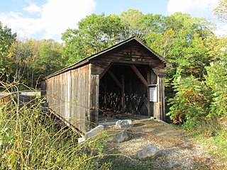
The Sawyers Crossing Covered Bridge, also known as the Cresson Bridge, is a wooden covered bridge carrying Sawyers Crossing Road over the Ashuelot River in west Swanzey, New Hampshire. Built in 1859 to replace an older bridge, it continues to serve as a part of Swanzey's transportation network, and is one of the state's few surviving 19th-century covered bridges. It was listed on the National Register of Historic Places in 1978.

The Blow-Me-Down Covered Bridge is a historic wooden covered bridge carrying Lang Road over Blow-me-down Brook in the town of Cornish, near its northern border with Plainfield, New Hampshire. Built in 1877, the kingpost structure is one of the state's few surviving 19th-century covered bridges. The bridge was listed on the National Register of Historic Places in 1978.
The Cold River Bridge, also known as McDermott Bridge, is a historic wooden covered bridge spanning the Cold River near Crane Brook Road in Langdon, New Hampshire, USA. Built in 1869, it is one of the state's few surviving 19th-century covered bridges. It was listed on the National Register of Historic Places in 1973. It is closed to vehicular traffic.

The Bement Covered Bridge is a historic wooden covered bridge on Center Road over the Warner River in Bradford, New Hampshire. A Long-truss bridge, it was built in 1854, and is one of New Hampshire's small number of surviving 19th-century covered bridges. It was listed on the National Register of Historic Places in 1976.
The Bath Covered Bridge is a historic covered bridge over the Ammonoosuc River off US 302 and NH 10 in Bath, New Hampshire. Built in 1832, it is one of the state's oldest surviving covered bridges. It was listed on the National Register of Historic Places in 1976, and underwent a major rehabilitation in the 2010s.
The Haverhill–Bath Covered Bridge is a historic covered bridge over the Ammonoosuc River joining Bath and Woodsville, New Hampshire. Formerly used to carry New Hampshire Route 135, the bridge was idled in 1999. Restored in 2004, it is now open to foot traffic only. It is believed to be the oldest covered bridge in the state.

The Swiftwater Covered Bridge is a historic covered bridge which carries Porter Road over the Wild Ammonoosuc River in Bath, New Hampshire. Built in 1849, it is one of New Hampshire's few surviving 19th-century covered bridges, and a well-preserved example of the Paddleford truss design. The bridge was added to the National Register of Historic Places in 1976.

The Contoocook Railroad Bridge is a covered bridge on the former Contoocook Valley Railroad line spanning the Contoocook River in the center of the village of Contoocook, New Hampshire, United States. It is referred to in the National Register of Historic Places as the Hopkinton Railroad Covered Bridge, for the town of Hopkinton, New Hampshire, in which the village of Contoocook is located.

The Golden Rod Grange No. 114 is a historic Grange hall on New Hampshire Route 32 in Swanzey, New Hampshire, United States. Built in 1916, it continues to occupy a significant place in the community as a meeting and function space. The little-altered building was listed on the National Register of Historic Places in 1994. It is now owned by the town and maintained by the Swanzey Preservation Society.

The Keniston Bridge is a historic covered bridge in Andover, New Hampshire, carrying Bridge Street over the Blackwater River. Built in 1882, it is of Town through truss construction, and is one of the few surviving 19th-century covered bridges in the state. It is also one of the only ones whose sides are not fully sheathed, exposing the trusses. The bridge was listed on the National Register of Historic Places in 1989.

The Hillsborough Railroad Bridge was a historic covered railroad bridge spanning the Contoocook River in Hillsborough, New Hampshire. Built in 1903 by the Boston and Maine Railroad, it was destroyed by arson in 1985. The bridge was listed on the National Register of Historic Places in 1975. At the time of its nomination it was one of six covered railroad bridges in the state; it and at least one other were destroyed by the actions of arsonists.

The Dingleton Hill Covered Bridge, also known as the Cornish Mills Bridge, is a historic wooden covered bridge, carrying Root Hill Road over Mill Brook in Cornish Mills, New Hampshire. Built in 1882, it is one of the state's few surviving 19th-century covered bridges. It was listed on the National Register of Historic Places in 1978. It carries one lane of traffic, with a posted weight limit.

The Meriden Bridge is a historic covered bridge in the Meriden area of Plainfield, New Hampshire. The bridge is a single span which carries Colby Hill Road over Bloods Brook, just west of a junction with Main Street and Willow Brook Road. Built about 1880, it is one of New Hampshire's few surviving 19th-century covered bridges. It was listed on the National Register of Historic Places in 1980.

The Centre Covered Bridge, also known as the Sanborn Covered Bridge, is a historic covered bridge, spanning the Passumpsic River next to U.S. Route 5 (US 5) north of the village of Lyndonville, Vermont. Built in 1872, it was moved to its present location and taken out of service in 1960. The bridge was located on Center Street between Lyndonville and Lyndon Center. It is one of three surviving Paddle-Ford truss bridges in Vermont. It was listed on the National Register of Historic Places in 1974. An amended National Register of Historic Places registration form was accepted by the National Park Service in 2024. The amendment fully documents the history and significance of the Centre Covered Bridge and lists it at the national level of significance.