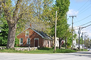
Chesham is an unincorporated community within the town of Harrisville in Cheshire County, New Hampshire, United States. Part of the village is listed on the National Register of Historic Places as the Chesham Village District, while the southernmost portions are included in the Pottersville District, also listed on the National Register.

Harrisville Historic District is a well-preserved historic New England mill village located in the southwest part of New Hampshire. It consists of about 200 acres (0.81 km2) and about 135 structures. It was declared a National Historic Landmark in 1977.
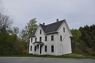
The Acre is a historic house at the corner of Main Street and Dublin Road in Harrisville, New Hampshire. Built about 1880 by the Cheshire Mill Company, it is a good example of period worker housing constructed by the company for itinerant workers. The house was listed on the National Register of Historic Places in 1988.
The John Adams Homestead/Wellscroft is a historic farmstead off West Sunset Hill Road in Harrisville, New Hampshire. The oldest portion of the farm's main house is a 1+1⁄2-story wood-frame structure built in the 1770s. It is one of the least-altered examples of early Cape style architecture in Harrisville, lacking typical alterations such as the additions of dormers and changes to the window sizes, locations, and shapes. The farmstead, including outbuildings and an area of roughly 2 acres (0.81 ha) distinct from the larger farm property, was listed on the National Register of Historic Places.

The Timothy Bancroft House is a historic house on Bancroft Road in Harrisville, New Hampshire. Located in a rural area once known as Mosquitoville, this c. 1785 wood-frame house was built by Timothy Bancroft, who operated a sawmill nearby that was one of the town's major industries for nearly a century. The house was listed on the National Register of Historic Places in 1988.

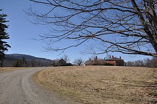
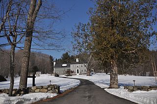
The Beech Hill Summer Home District encompasses a collection of six early 20th century summer houses in Harrisville, New Hampshire, built on a ridge overlooking Dublin Pond with views of nearby Mount Monadnock. The properties, a number of which were built for members of the Thayer family, lie on Mason Road, just north of the town line with Dublin. The most significant property of the six is the 140-acre (57 ha) Skyfield estate, whose large Georgian Revival mansion was designed by Lois Lilley Howe and built in 1916. The district is also notable as containing archaeological remnants of 18th century farmsteads, for which reason its properties are also listed in the Harrisville Rural District. The district was listed on the National Register of Historic Places in 1988.

The George Cheever Farm is a historic farmstead at the corner of Nelson and Tolman Pond Roads in Harrisville, New Hampshire. This 1½-story wood-frame house was built in the early 1860s, and is a well-preserved example of a period farmhouse. It is architecturally distinctive because of a rear saltbox style addition, and its shed-roof dormers. The house was listed on the National Register of Historic Places in 1988.
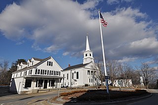
The Dublin Village Historic District encompasses the historic village center of Dublin, New Hampshire. Dublin's center developed in the 19th century after its original village center was abandoned due to harsher winter conditions nearer Dublin Pond. The district extends along Main Street from its junction with Lake Street in the west to the junction with Old County Road in the east, and includes sections of Old Common Road, Harrisville Road, and Church Street. The district was listed on the National Register of Historic Places in 1983.
The Eli Morse Farm is a historic farm on Lake Road in Dublin, New Hampshire. It is one of the earliest settlements in the town, settled by Eli Morse in 1764, and has been in the hands of just two families. Its transformation to summer resort use was one of the first in the Dublin Pond area. The farm was listed on the National Register of Historic Places in 1983.

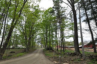
The Pottersville District encompasses the earliest non-Native settlement in Harrisville, New Hampshire, as well as sites of some of the town's earliest industrial activities. The 93-acre (38 ha) district includes forty buildings and two archaeological sites, and was listed on the National Register of Historic Places in 1986.
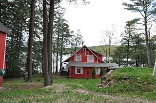
The Silver Lake District is a historic district encompassing a summer resort area along the southern section of Silver Lake in Harrisville, New Hampshire. It includes a collection of summer cottages built along or near the shores of the lake between about 1880 and 1903, a period of prosperity in Harrisville and nearby Keene. It is unusual in that most of the owners and occupants of its properties were from nearby towns, and not from further afield, as the populations of the summer colonies of Nelson and Dublin were. The district covers 66 acres (27 ha) from the town line between Harrisville and Nelson to the southern end of the lake, and includes 76 contributing buildings. It was listed on the National Register of Historic Places in 1986.

The Silver Lake Farm is a historic farmstead on Seaver Road in northwestern Harrisville, New Hampshire. Established about 1820, it was a highly successful local farm, serving first businesses as far off as Keene, and then the local summer resort trade at nearby Silver Lake. The house is relatively little-altered despite intensive use into the 20th century. The farmstead was listed on the National Register of Historic Places in 1988.

The Smith–Mason Farm is a historic farmstead at Meadow Road and Old Roxbury Road in Harrisville, New Hampshire. First developed in the late 18th century, the property has been adaptively used as a farm, summer estate, and family residence, representing major periods in Harrisville's development. The property was listed on the National Register of Historic Places in 1988.
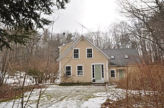
The Jabez Townsend House is a historic house at the southwest corner of Hancock and Cherry Hill Roads in Harrisville, New Hampshire. Built in 1853, it is a good local example of a rural Greek Revival farmhouse. The house was listed on the National Register of Historic Places in 1988.

The Townsend Farm is a historic farmstead on East Harrisville Road in Dublin, New Hampshire. Built about 1780 and enlarged about 1850 and again at the turn of the 20th century, it is one of Dublin's older houses, notable as the home and studio of artist George DeForest Brush, one of the leading figures of Dublin's early 20th-century art colony. The house was listed on the National Register of Historic Places in 1983.
The New Ipswich Center Village Historic District encompasses the historic center of the rural town of New Ipswich, New Hampshire. The center village is the town's most densely populated area, with a history dating to the town's founding in 1735. The district extends along Turnpike Road between King and Porter Roads, and southward in a roughly triangular shape, the southern point of which is at the junction of Main Street and Willard Road. The village includes a large number of residences, which were mainly agricultural at first, but also include a number of properties built as summer resort houses in the late 19th and early 20th centuries. It also includes most of the town's historic civic buildings, including its historic town hall, and the Barrett House, now a museum property owned by Historic New England. The district was listed on the National Register of Historic Places in 1991.

The Old County Road South Historic District is a rural historic district encompassing a well-preserved collection of 18th and early 19th-century rural farm properties in Francestown, New Hampshire. It includes nine houses, whose construction dates from 1774 to 1806, and the only two extant 18th-century saltbox-style houses in the town. There is also a Cape-style house built using the relatively rare vertical-plank method of framing, and there are several surviving 19th-century barns. The district covers 500 acres (200 ha) along all or part of Old County Road South, Pratt (Clark) Road, and Birdsall Road. The district was listed on the National Register of Historic Places in 1980.
The Highland Road Historic District is a historic district encompassing a rural neighborhood in South Hampton, Rockingham County, New Hampshire. The historic farm estates which characterize the neighborhood date to the turn of the 18th century. The district was added to the National Register of Historic Places (NRHP) in 1983.

The Houghtonville Historic District encompasses a cluster of residential properties that are all that remain of one of the early industrial areas of Grafton, Vermont. Located west of Grafton Village on Houghtonville Road, it includes ten well-preserved 19th-century houses, some located on properties where early mills once stood. The district was listed on the National Register of Historic Places in 2015.
The Maple Hill Farm is a historic farm property at 65 Maple Hill Road in Norwich, Vermont. Encompassing more than 40 acres (16 ha) of woodlands and pasture, the farm has more than 200 years of architectural history, including a late 18th-century farmhouse built by Peter Olcott, and two barns from that period. It remained an active farm property until 1966. The property was listed on the National Register of Historic Places in 2020.