Sawyers Crossing Covered Bridge

Last updated
Sawyers Crossing Covered Bridge
Cresson Bridge, Swanzey NH.jpg
Sawyers Crossing/Cresson Bridge
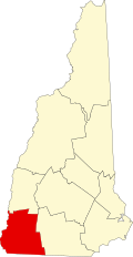
USA New Hampshire location map.svg
Red pog.svg
Usa edcp location map.svg
Red pog.svg
LocationSawyers Crossing Road over the Ashuelot River, Swanzey, New Hampshire
Coordinates 42°53′10″N72°17′12″W / 42.88611°N 72.28667°W / 42.88611; -72.28667
Arealess than one acre
Built1859 (1859)
Architectural styleTown truss
NRHP reference No. 78000211 [1]
Added to NRHPNovember 14, 1978

The Sawyers Crossing Covered Bridge , also known as the Cresson Bridge, is a wooden covered bridge carrying Sawyers Crossing Road over the Ashuelot River in west Swanzey, New Hampshire. Built in 1859 to replace an older bridge, it continues to serve as a part of Swanzey's transportation network, and is one of the state's few surviving 19th-century covered bridges. It was listed on the National Register of Historic Places in 1978. [1]

Contents

Description and history

The Sawyers Crossing Covered Bridge is located west of Swanzey's village center, spanning the Ashuelot River in a roughly east–west orientation. It is a two-span Town truss construction, resting on abutments and a central pier made of split granite. Its exterior is finished in vertical board siding, and it is covered by a metal gabled roof. The portals are rectangular with rounded corners at the top. It is 117 feet (36 m) long and 17 feet (5.2 m) wide. [2]

The bridge was built in 1859 to replace a bridge built in 1771. It has had metal parts (tie rods and bolts) added to increase its strength, and it continues to receive regular maintenance. In 1983, repairs were made by Evroke Corporation of Laconia and a significant renovation was made by Wright Construction Co., Inc. of Mount Holly, Vermont, in 1996. [3]

The bridge gained some notice in 1953, when a picture of it was used in a cigarette advertising campaign, in which it was known as the "kissing bridge". [2]

See also

Related Research Articles

<span class="mw-page-title-main">Swanzey, New Hampshire</span> Town in New Hampshire, United States

Swanzey is a town in Cheshire County, New Hampshire, United States. The population was 7,270 at the 2020 census. In addition to the town center, Swanzey includes the villages of East Swanzey, West Swanzey, North Swanzey and Westport.

<span class="mw-page-title-main">Ashuelot River</span> River in New Hampshire, United States

The Ashuelot River is a tributary of the Connecticut River, approximately 64 miles (103 km) long, in southwestern New Hampshire in the United States. It drains a mountainous area of 425 square miles (1,101 km2), including much of the area known as the Monadnock Region. It is the longest tributary of the Connecticut River within New Hampshire.

<span class="mw-page-title-main">Columbia Bridge (Connecticut River)</span> Bridge in New Hampshire and Lemington, Vermont

The Columbia Bridge is a covered bridge, carrying Columbia Bridge Road over the Connecticut River between Columbia, New Hampshire and Lemington, Vermont. Built in 1911–12, it is one of only two New Hampshire bridges built with Howe trusses, and is one of the last covered bridges built in the historic era of covered bridge construction in both states. It was listed on the National Register of Historic Places in 1976.

<span class="mw-page-title-main">Mount Orne Covered Bridge</span> Bridge in New Hampshire to Lunenburg, Vermont

The Mount Orne Bridge is a covered bridge over the Connecticut River between Lancaster, New Hampshire, and Lunenburg, Vermont. It joins Elm Street in South Lancaster with River Road in Lunenburg. Built in 1911, it is one of two Howe truss bridges across the Connecticut River. It was listed on the National Register of Historic Places in 1976.

<span class="mw-page-title-main">West Swanzey Covered Bridge</span> United States historic place

The West Swanzey Covered Bridge is a historic wooden covered bridge carrying Main Street over the Ashuelot River in West Swanzey, New Hampshire. Built in 1832, it is one of New Hampshire's few surviving 19th-century covered bridges. Unlike most of those, it is prominently located in the village, providing access from the village center to New Hampshire Route 10. The bridge was listed on the National Register of Historic Places in 1980.

<span class="mw-page-title-main">Slate Covered Bridge</span> Covered bridge in Swanzey, New Hampshire, US

The Slate Covered Bridge is a wooden covered bridge which carries the Westport Village Road over the Ashuelot River in Westport, a village of Swanzey, New Hampshire. The bridge was built in 2001, as a replacement for an 1862 bridge that was destroyed by arson fire in 1993. The 1862 bridge, one of New Hampshire's small number of surviving 19th-century covered bridges, was listed on the National Register of Historic Places in 1978.

<span class="mw-page-title-main">Coombs Covered Bridge</span> United States historic place

The Coombs Covered Bridge is a wooden covered bridge which carries Coombs Bridge Road over the Ashuelot River in northern Winchester, New Hampshire. It was built in 1843, and is one of the state's small number of surviving 19th-century covered bridges. It was listed on the National Register of Historic Places in 1976.

<span class="mw-page-title-main">Carleton Bridge</span> United States historic place

The Carlton Bridge is a historic wooden covered bridge that carries Carlton Road over the South Branch Ashuelot River in East Swanzey, New Hampshire. The bridge was built in 1869, and is the region's only surviving example of a 19th-century Queenspost truss bridge. The bridge was listed on the National Register of Historic Places in 1975.

<span class="mw-page-title-main">Ashuelot Covered Bridge</span> United States historic place

The Ashuelot Covered Bridge is a historic wooden covered bridge over the Ashuelot River on Bolton Road, just south of its intersection with NH 119 in Ashuelot, an unincorporated village of Winchester, New Hampshire. Built in 1864-65, it is one of the state's few surviving 19th-century covered bridges. It was listed on the National Register of Historic Places in 1981.

<span class="mw-page-title-main">Cold River Bridge (Langdon, New Hampshire)</span> United States historic place

The Cold River Bridge, also known as McDermott Bridge, is a historic wooden covered bridge spanning the Cold River near Crane Brook Road in Langdon, New Hampshire, USA. Built in 1869, it is one of the state's few surviving 19th-century covered bridges. It was listed on the National Register of Historic Places in 1973. It is closed to vehicular traffic.

<span class="mw-page-title-main">Dalton Covered Bridge</span> United States historic place

The Dalton Covered Bridge, also called the Dalton Bridge, is a historic covered bridge that carries Joppa Road over the Warner River in Warner, New Hampshire. Its name refers to a nearby resident at the time of its construction. The bridge was built in 1853 by Joshua Sanborn, and its original abutments were built by George Sawyer and Webster Davis; all were local residents. The bridge has a span of 76 feet (23 m), with a total bridge length of 84 feet (26 m). The bridge is 17 feet (5.2 m) wide, with a road bed width of 14 feet (4.3 m), although guard rails have reduced its usable width to just under 13 feet (4.0 m).

<span class="mw-page-title-main">Hancock–Greenfield Bridge</span> United States historic place

The Hancock–Greenfield Bridge is a historic covered bridge carrying Forest Road over the Contoocook River at the town line between Hancock and Greenfield, New Hampshire. The New Hampshire Department of Transportation covered bridge database refers to it as County Bridge. Built in 1937, it is the first wooden covered bridge in the northeastern United States to use modern engineering techniques. The bridge was listed on the National Register of Historic Places in 1981.

<span class="mw-page-title-main">Capon Lake Whipple Truss Bridge</span> Bridge in West Virginia

The Capon Lake Whipple Truss Bridge, formerly known as South Branch Bridge or Romney Bridge, is a historic Whipple truss bridge in Capon Lake, West Virginia. It is located off Carpers Pike and crosses the Cacapon River. The bridge formerly carried Capon Springs Road over the river, connecting Capon Springs and Capon Lake.

<span class="mw-page-title-main">Bog Bridge</span> United States historic place

The Bog Bridge, also known as the Cilleyville Bridge, is a historic covered bridge in Andover, New Hampshire. Built in 1887 and located off New Hampshire Route 11 west of Andover center, the Town lattice truss bridge is one of New Hampshire's few surviving 19th-century covered bridges, and is relatively little altered since its construction, having had its roof replaced and an abutment reconstructed. The bridge was listed on the National Register of Historic Places in 1989.

<span class="mw-page-title-main">Rowell's Covered Bridge</span> United States historic place

Rowell's Covered Bridge is a covered bridge in West Hopkinton, New Hampshire, which carries Rowell Bridge Road over the Contoocook River. The Long truss bridge was completed in 1853, and is one of New Hampshire's few surviving 19th-century covered bridges. It was listed on the National Register of Historic Places in 1976. It is named for Abram Rowell, an early resident of the area.

<span class="mw-page-title-main">Waterloo Covered Bridge</span> United States historic place

The Waterloo Covered Bridge carries Newmarket Road over the Warner River near the Waterloo Falls in Warner, New Hampshire. The Town lattice truss bridge was built in 1859–60, replacing an earlier span at the same location, and is one of New Hampshire's few surviving 19th-century covered bridges. The bridge was listed on the National Register of Historic Places in 1976, and included in the Waterloo Historic District in 2003.

<span class="mw-page-title-main">Gilsum Stone Arch Bridge</span> United States historic place

The Gilsum Stone Arch Bridge carries Surry Road over the Ashuelot River in Gilsum, New Hampshire. Built in 1862–63, it is one of the highest stone arch bridges in the state. It has a span of 47 feet 8 inches (14.53 m), and an average height over the river of 36 feet 6 inches (11.13 m). The roadway is 43 feet 6 inches (13.26 m) above the riverbed. It stands on the site of four previous bridges, where the river passes through a deep gorge. The previous bridge was also a stone arch bridge, which was built in 1860 and collapsed a few months later. It was designed by William Leonard Kingsbury, a local official; its builders are not known because the town's records were destroyed in a fire. The present bridge's vault is carefully constructed from dry-laid granite voussoirs that were shaped for a very precise fit, with larger stones at the lower ends of the arch, and a smaller ones at the crown. Some of the stones were left with rough surfaces, while others were hammered smooth.

<span class="mw-page-title-main">Morey Memorial Bridge</span> United States historic place

The Samuel Morey Memorial Bridge is a historic bridge carrying New Hampshire Route 25A across the Connecticut River between Orford, New Hampshire and Fairlee, Vermont. The steel through-arch bridge was built in 1937–38 to replace an older wooden bridge which had been damaged by flooding in 1936. It spans 432 feet (132 m), stands about 35 feet (11 m) above the river, and its arches rise 85 feet (26 m) above the roadway. It rests on poured concrete abutments that have a light Art Deco or Moderne styling. Wing walls recede from the abutments into the banks in three stepped sections. Below the bridge in the river is visible some riprap, stone remnants of the old bridge's abutments and central pier. The bridge is of a "tied arch" design, in which the two arches are joined together by ties to distribute the active load. This is in contrast to the Justice Harlan Fiske Stone Bridge joining Brattleboro, Vermont and Chesterfield, New Hampshire, which was built about the same time, and distributes the active load to its abutments. The bridge components were manufactured by the American Bridge Company; construction was by Hagen-Thibodeau Construction Company at a contracted cost of just over $209,000.

<span class="mw-page-title-main">Durgin Bridge</span> United States historic place

The Durgin Bridge is a covered bridge carrying Durgin Bridge Road over the Cold River in eastern Sandwich, New Hampshire. Built in 1869, it is a rare surviving example of a Paddleford truss bridge, and one of the few surviving 19th-century covered bridges in New Hampshire. It was listed on the National Register of Historic Places in 1983.

<span class="mw-page-title-main">Best's Covered Bridge</span> United States historic place

Best's Covered Bridge(akaSwallow's Bridge) is a historic covered bridge in West Windsor, Vermont, that carries Churchill Road over Mill Creek, just south of Vermont Route 44. Built in 1889, it is an architecturally distinctive laminated arch structure with a post-and-beam superstructure. It was listed on the National Register of Historic Places in 1973.

References

  1. 1 2 "National Register Information System". National Register of Historic Places . National Park Service. March 13, 2009.
  2. 1 2 "NRHP nomination for Sawyers Crossing Covered Bridge". National Park Service. Retrieved 2014-04-26.
  3. Chandler, Kim Varney (November 2022). Covered Bridges of New Hampshire. Peter E. Randall Publisher. ISBN   9781942155522.{{cite book}}: CS1 maint: date and year (link)

Commons-logo.svg Media related to Cresson Bridge at Wikimedia Commons

Side view of the bridge Cresson Bridge.jpg
Side view of the bridge