
Clarksville is a town in northern Coös County, New Hampshire, United States. The population was 294 at the 2020 census. It is part of the Berlin, NH–VT Micropolitan Statistical Area.

Pittsburg is a town in Coös County, New Hampshire, United States. The population was 800 at the 2020 census. It is the northernmost town in New Hampshire and the largest town by area in New England. U.S. Route 3 is the only major highway in the town, although the northern terminus of New Hampshire Route 145 also lies within Pittsburg.

The Connecticut River is the longest river in the New England region of the United States, flowing roughly southward for 406 miles (653 km) through four states. It rises 300 yards south of the U.S. border with Quebec, Canada, and discharges at Long Island Sound. Its watershed encompasses 11,260 square miles (29,200 km2), covering parts of five U.S. states and one Canadian province, via 148 tributaries, 38 of which are major rivers. It produces 70% of Long Island Sound's fresh water, discharging at 18,400 cubic feet (520 m3) per second.

The Connecticut Lakes are a group of lakes in Coos County, northern New Hampshire, United States, situated along the headwaters of the Connecticut River. They are accessed via the northernmost segment of U.S. Route 3, between the village of Pittsburg and the Canada port of entry south of Chartierville, Quebec. The lakes are located within the boundaries of Pittsburg, but are far from the town center. Connecticut Lakes State Forest adjoins them.

Merrill Creek Reservoir, located in Harmony Township, New Jersey in central Warren County, New Jersey, is a 650-acre (260 ha) artificial lake designed to hold 15 billion gallons of water that is surrounded by 290 acres (120 ha) of protected woodland and fields. These lands are themselves part of 2,000 acres (8.1 km2) of open spaces.

Raystown Lake is a reservoir in Huntingdon County, Pennsylvania. It is the largest lake that is entirely within Pennsylvania. The original lake was built by the Simpson family of Huntingdon as a hydroelectric project. The current 8,300-acre (34 km2) Raystown Lake was completed in 1973 by the Army Corps of Engineers. Raystown is around 200 feet (61 m) deep in the deepest area near the dam. The lake was created primarily to control floods, provide electricity, and support recreational activities. Allegheny Electric Cooperative operates the Raystown Hydroelectric Project and William F. Matson Generating Station at the Raystown Dam, a 21 MW, two-unit hydroelectric project.

Conway Lake is a 1,316-acre (5 km2) water body with a maximum depth of 45 feet (14 m), located in Carroll County in eastern New Hampshire, in the United States. The lake is located in the towns of Conway and Eaton, just to the east of the White Mountains, and is part of the Saco River watershed.

Back Lake is a 348-acre (141 ha) water body located in Coos County in northern New Hampshire, United States, in the town of Pittsburg. It is part of the Connecticut River watershed. It is situated north of Lake Francis and west of First Connecticut Lake. U.S. Route 3 passes by Back Lake's eastern shore.

Goose Pond is a 625-acre (2.5 km2) water body located in Grafton County in western New Hampshire, United States, in the towns of Canaan and Hanover. It is considered a great pond by the state of New Hampshire. The lake has 6.3 miles (10.1 km) of shoreline, and is approximately 3 miles (5 km) long by 0.5 miles (0.8 km) wide. All but the northernmost end of the pond is in the town of Canaan. The average depth of the pond is approximately 10 feet (3.0 m), with the deepest part approximately 35 feet (11 m). The lake is part of the Mascoma River watershed, flowing to the Connecticut River.

Silver Lake is a 346-acre (1.40 km2) water body located in Cheshire County in southwestern New Hampshire, United States, in the towns of Harrisville and Nelson. Water from Silver Lake flows via Minnewawa Brook and The Branch to the Ashuelot River, a tributary of the Connecticut River.
Stinson Lake is a 342-acre (1.38 km2) water body located in the town of Rumney in Grafton County, New Hampshire, United States. The lake is in the southern part of the White Mountains and is the largest lake in the White Mountain National Forest. Water from Stinson Lake flows via Stinson Brook, the Baker River, and the Pemigewasset River to the Merrimack River.

Surry Mountain Lake is a 353-acre (1.43 km2) impoundment on the Ashuelot River in Cheshire County in southwestern New Hampshire, United States, in the town of Surry.

Lake Burton is a 2,775 acre (11.23 km²) reservoir with 62 miles (100 km) of shoreline located in the northeastern corner of Georgia in Rabun County. The lake is owned and administered by the Georgia Power/Southern Company, but it is a public lake. Noted for the remarkable clarity of its water and surrounded by the biodiverse ecosystem of the Blue Ridge Mountains, the lake celebrated its centennial in 2020.
Watauga Lake, located east of Elizabethton, Tennessee, is the local name of the Watauga Reservoir created by the Tennessee Valley Authority (TVA) with the 1948 completion of the TVA Watauga Dam.
The Quinebaug River is a river in south-central Massachusetts and eastern Connecticut, with watershed extending into western Rhode Island. The name "Quinebaug" comes from the southern New England Native American term, spelled variously Qunnubbâgge, Quinibauge, etc., meaning "long pond", from qunni-, "long", and -paug, "pond". The river is one of the namesake rivers in the Quinebaug and Shetucket Rivers Valley National Heritage Corridor.

Lows Lake is a lake in the Adirondack Park in northeastern New York. It is in the New York State Forest Preserve Five Ponds Wilderness Area, 10 miles (16 km) southwest of Tupper Lake. The Adirondack Park Agency classifies the lake as a Primitive Area meaning that it is wilderness in character, but contains artificial structures and private lands.

Lake Sunapee is located within Sullivan County and Merrimack County in western New Hampshire, the United States. It is the fifth-largest lake located entirely in New Hampshire.

Willard Pond is a small, protected lake in Antrim, New Hampshire, United States. The lake, located in southwestern New Hampshire, is about 108 acres (44 ha) in size with an average depth of 25 feet (7.6 m) and a maximum depth of 58 feet (18 m). No petroleum motors are allowed, and fly fishing is the only form of fishing allowed. It is part of the dePierrefeu Wildlife Sanctuary, which is owned by the New Hampshire Audubon Society. Because the pond and the land around it are part of the sanctuary, the shore is unable to be developed. Therefore, there are no buildings around the pond and there won't be in the foreseeable future. Willard is instead surrounded by extensive amounts of wilderness and hiking trails that lead around the pond and to the summits of Bald Mountain and Goodhue Hill. Willard is a popular fishing, boating and hiking destination, and it has become more popular with its mention in numerous magazines and newspapers.

Moore Dam is a major hydroelectric dam on the Upper Connecticut River between Grafton County, New Hampshire and Caledonia County, Vermont in the northeastern United States. The dam is located near Littleton, New Hampshire, and forms the 3,490-acre (1,410 ha) Moore Reservoir. The Moore Station is the largest conventional hydroelectric plant in New England, in terms of installed capacity and average power generation. The dam and reservoir also provide flood control, recreational boating and fishing.
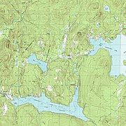 Topographical map of Lake Francis (bottom center), with Back Lake to its north, and First Connecticut Lake to the northeast
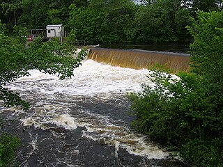
 View of Murphy Dam looking up at the embankment; fence in the foreground is part of a local baseball field
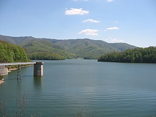
 View of Lake Francis at the public boat launch along U.S. Route 3
 View looking south from near the boat launch


