
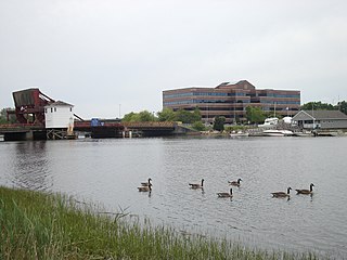
Easthampton is a city in Hampshire County, Massachusetts, United States. The city is in the Pioneer Valley, near the five colleges in the college towns of Northampton and Amherst. The population was 16,211 at the 2020 census.

The city of Northampton is the county seat of Hampshire County, Massachusetts, United States. As of the 2020 census, the population of Northampton was 29,571.

The River Etherow in northern England is a tributary of the River Goyt. Although now passing through South Yorkshire, Derbyshire and Greater Manchester, it historically formed the ancient county boundary between Cheshire and Derbyshire. The upper valley is known as Longdendale. The river has a watershed of approximately 30 square miles (78 km2), and the area an annual rainfall of 52.5 inches (1,330 mm).
The Neponset River is a river in eastern Massachusetts in the United States. Its headwaters are at the Neponset Reservoir in Foxborough, near Gillette Stadium. From there, the Neponset meanders generally northeast for about 29 miles (47 km) to its mouth at Dorchester Bay between Quincy and the Dorchester section of Boston, near the painted gas tank.

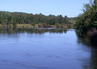
Western Massachusetts, known colloquially as "western Mass," is a region in Massachusetts, one of the six U.S. states that make up the New England region of the United States. Western Massachusetts has diverse topography; 22 colleges and universities including UMass in Amherst, MA, with approximately 100,000 students; and such institutions as Tanglewood, the Springfield Armory, and Jacob's Pillow.
The Nashua River, 37.5 miles (60.4 km) long, is a tributary of the Merrimack River in Massachusetts and New Hampshire in the United States. It is formed in eastern Worcester County, Massachusetts, at the confluence of the North Nashua River and South Nashua River, and flows generally north-northeast past Groton to join the Merrimack at Nashua, New Hampshire. The Nashua River watershed occupies a major portion of north-central Massachusetts and a much smaller portion of southern New Hampshire.

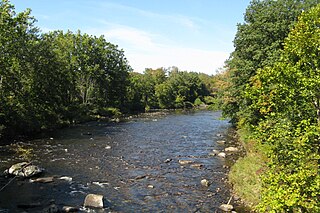
The Mill River is a 13.5-mile-long (21.7 km) tributary of the Connecticut River arising in the western hilltowns of Hampshire County, Massachusetts. It is notable for dropping in elevation, along with its West Branch, more than 700 feet (210 m) over 15 miles (24 km).

The Metacomet-Monadnock Trail is a 114-mile-long (183 km) hiking trail that traverses the Metacomet Ridge of the Pioneer Valley region of Massachusetts and the central uplands of Massachusetts and southern New Hampshire. Although less than 70 miles (110 km) from Boston and other large population centers, the trail is considered remarkably rural and scenic and includes many areas of unique ecologic, historic, and geologic interest. Notable features include waterfalls, dramatic cliff faces, exposed mountain summits, woodlands, swamps, lakes, river floodplain, farmland, significant historic sites, and the summits of Mount Monadnock, Mount Tom and Mount Holyoke. The Metacomet-Monadnock Trail is maintained largely through the efforts of the Western Massachusetts Chapter of the Appalachian Mountain Club (AMC). Much of the trail is a portion of the New England National Scenic Trail.
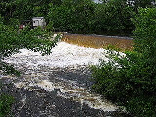
The Westfield River is a major tributary of the Connecticut River located in the Berkshires and Pioneer Valley regions of western Massachusetts. With four major tributary branches that converge west of the city of Westfield, it flows 78.1 miles (125.7 km) before its confluence with the Connecticut River at Agawam, across from the city of Springfield's Metro Center district. Known for its whitewater rapids and scenery, the Westfield River provides over 50 miles (80 km) of whitewater canoeing and kayaking, in addition to one of the largest roadless wilderness areas remaining in the Commonwealth.
The Quinebaug River is a river in south-central Massachusetts and eastern Connecticut, with watershed extending into western Rhode Island. The name "Quinebaug" comes from the southern New England Native American term, spelled variously Qunnubbâgge, Quinibauge, etc., meaning "long pond", from qunni-, "long", and -paug, "pond". The river is one of the namesake rivers in the Quinebaug and Shetucket Rivers Valley National Heritage Corridor.

The Norwottuck Branch Rail Trail, full name the Norwottuck Branch of the Mass Central Rail Trail, formerly the Norwottuck Rail Trail, is an 11-mile (18 km) combination bicycle/pedestrian paved rail trail running from Northampton, Massachusetts, through Hadley and Amherst, to Belchertown, Massachusetts. It opened in 1993, and is now part of the longer Mass Central Rail Trail.

Route 141 is a 17.18-mile-long (27.65 km) west–east state highway in the U.S. state of Massachusetts. Its western terminus is at Route 10 in Easthampton. Its eastern terminus is at US 20 in Springfield, a terminus it shares with Route 21. Route 141 gained notoriety in the local media in July 2005 when signage posted by contractors at the junction with Route 10 in Easthampton was posted incorrectly in the form of signage seen in Alabama.
The Mount Tom Range is a traprock mountain range located in the Connecticut River Valley of Massachusetts. It is a subrange of the Appalachians and part of the Metacomet Ridge that extends from Long Island Sound near New Haven, Connecticut, north through the Connecticut River Valley of Massachusetts to nearly the Vermont border. A popular outdoor recreation resource, the range is known for its continuous west facing cliffs and its rugged, scenic character. It is also notable for its unique microclimate ecosystems and rare plant communities, as well as significant historic sites, such as the ruins of the 18th century Eyrie House located on Mount Nonotuck.

West Hill Dam Reserve is a United States Army Corps of Engineers flood control project with a recreational park and wildlife management area located at Uxbridge, Massachusetts. The West Hill Dam Project was completed in June 1961. It is located on the West River, one of the branches of the Blackstone River which flows from Worcester, Massachusetts, to Providence, Rhode Island. The West River originates in Grafton, Massachusetts, at Cider Mill Pond and Silver Lake, near Upton, Massachusetts, and the Upton State Forest. The dam is unusual in that it is not filled unless there is a flood. West Hill Dam was built after devastating floods during the 1950s; it is intended to protect the Blackstone Valley from future destructive flooding. The cities and towns downriver from Uxbridge, including Millville, Blackstone, Woonsocket, North Smithfield, Cumberland, Lincoln, Central Falls, Pawtucket and Providence, Rhode Island, suffered extensive flooding from the Blackstone during Hurricane Diane in 1955. Hurricane Donna tested this new dam in 1960 as the eyewall passed over. The West Hill Dam is located in the Blackstone River Valley National Heritage Corridor near the Blackstone River and Canal Heritage State Park. Park rangers provide visitor assistance and offer scheduled interpretative programs. Fishing, hunting, and wildlife viewing opportunities are available year-round. The park has a recreation area, 34 picnic sites, one playground, a swimming area and five miles of hiking trails. However, access to the park from West Hill Road is currently blocked as of 2021 because of landowner disagreements. West Hill Dam is also the field office for the Charles River Natural Valley Storage Area. It consists of scattered wetlands in the upper and middle Charles River watershed, between the towns of Bellingham and Needham. The wetlands provide flood storage area, fisheries, wildlife management, and recreation. The Charles River is the well-known watercourse that flows into Boston Harbor.
Commonwealth Connections is a greenway and conservation initiative co-developed by the Commonwealth of Massachusetts Department of Conservation and Recreation (DCR), the National Park Service, and over fifty trail and land conservation agencies and non-profit organizations. Begun in 1999, the initiative was designed to create "a coordinated greenway and trail network that will help conserve important resources, provide recreation and alternative transportation opportunities close to where people live, and connect communities throughout Massachusetts."

The Manhan Rail Trail is a rails-to-trails paved recreational trail and non-motorized commuter route located in the lower Connecticut River Valley of Massachusetts in the town of Easthampton. The 6-mile-long (9.7 km) trail, completed in 2003, is part of the larger New Haven and Northampton Canal Greenway that would extend from New Haven, Connecticut, to Northampton, Massachusetts. The trail, named after the Manhan River which it parallels, utilizes the bed of the former New Haven and Northampton Railroad, which served the industrial towns of the lower Pioneer Valley from the mid-19th century until 1992. It begins at the Northampton-Easthampton line near Route 10 and ends at Coleman Road, just over the Southampton town line. There are plans to extend the route south through Southampton and eventually to Westfield to connect with the Columbia Greenway.

The Main Street Historic District of Easthampton, Massachusetts encompasses the historic heart of the town, running along Main Street between Northampton and Center Streets. The area has been the civic and economic heart of the town since incorporation in 1785. Most of the commercial buildings date from the 1840s to the 1880s, and are built in an Italianate style. The housing stock of the district also includes Italianate styling, but there are also a number of Greek Revival structures. The major civic structures of the town are in the district, including the town hall, public library, and the First Congregational Church, which is the second for the congregation, a brick Romanesque Revival building dating to 1851. The district was added to the National Register of Historic Places in 1986.

Spencer State Forest is a Massachusetts state forest and recreation reserve located in the town of Spencer, managed by the Massachusetts Department of Conservation and Recreation. The 92 mile (148 km) Midstate Trail passes through the state forest. The Commonwealth of Massachusetts also conducts logging in some parts of the property.
The Hubbard River, 4.6 miles (7.4 km) long, is part of the Farmington River watershed. It flows through Connecticut and Massachusetts.
The New Haven and Northampton Canal Greenway is a proposed and partially completed, paved rail trail and non-motorized commuter route along the former right of way of the New Haven and Northampton Railroad. It currently has 63 miles (101 km) open, and when complete it will be 81.2 miles (130.7 km), running from New Haven, Connecticut to Northampton, Massachusetts. It consists of the following trails, from north to south:

