
Hanover is a town in Plymouth County, Massachusetts, United States. The population was 14,833 at the 2020 census.

Pembroke is an historic town in Plymouth County, Massachusetts, United States. Pembroke is a South Shore suburb of the Boston metropolitan area. The town is located approximately halfway between Boston and Cape Cod. The town is considered rural in character, with pockets of suburban neighborhoods. The population was 18,361 at the 2020 census, with a median household income of $119,827.
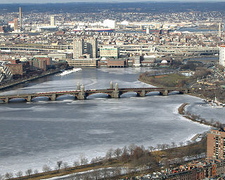
The Charles River, sometimes called the River Charles or simply the Charles, is an 80-mile-long (129 km) river in eastern Massachusetts. It flows northeast from Hopkinton to Boston along a highly meandering route, that doubles back on itself several times and travels through 23 cities and towns before reaching the Atlantic Ocean. The indigenous Massachusett named it Quinobequin, meaning "meandering" or "meandering still water".

Hanson is a town in Plymouth County, Massachusetts, United States. Part of Greater Boston, Hanson is located 20 miles (32 km) south of Boston and is one of the inland towns of the South Shore. The population was 10,639 at the 2020 census.

The Assonet River is located in Bristol County, Massachusetts. It flows 7.4 miles (11.9 km) in a westerly direction through Freetown and joins the Taunton River near Assonet Neck in Berkley, Massachusetts.

The Assabet River is a small, 34.4-mile (55.4 km) long river located about 20 miles (30 km) west of Boston, Massachusetts, United States. The Assabet rises from a swampy area known as the Assabet Reservoir in Westborough, Massachusetts, and flows northeast before merging with the Sudbury River at Egg Rock in Concord, Massachusetts, to become the Concord River. The Organization for the Assabet, Sudbury and Concord Rivers, headquartered in West Concord, Massachusetts, is a non-profit organization dedicated to the preservation, protection, and enhancement of the natural and recreational features of these three rivers and their watershed. As the Concord River is a tributary of the Merrimack River, it and the Assabet and Sudbury rivers are part of the larger Merrimack River watershed.

Saxonville is a village located in northern Framingham, in Middlesex County, Massachusetts, United States. The village was originally settled by John Stone in 1647. Saxonville was named after the Saxon Factory Company.
The Satucket River is 5.5-mile-long (8.9 km) river in southeastern Massachusetts within the Taunton River Watershed. It flows generally west from Robbins Pond in East Bridgewater, and into the Matfield River.

The Jones River is a 7.5-mile-long (12.1 km) river running through Kingston, Massachusetts. The river drains about 30 square miles (78 km2), has its source in Silver Lake and drains into Kingston Bay. Land surrounding the river is 52% forested, of which 22% has been developed for residential use. There is a USGS stream gauge along 16 square miles (41 km2) of the river and it has measured the flow at 0.7 cubic feet per second (0.020 m3/s) per square mile of drainage area.

Mother Brook is a stream that flows from the Charles River in Dedham, Massachusetts, to the Neponset River in the Hyde Park section of Boston, Massachusetts. Mother Brook was also known variously as East Brook and Mill Creek in earlier times. Digging the brook made Boston and some surrounding communities an island, accessible only by crossing over water, making Mother Brook "Massachusetts' Panama Canal."
Ipswich River is a small river in northeastern Massachusetts, United States. It held significant importance in early colonial migrations inland from the ocean port of Ipswich. The river provided safe harborage at offshore Plum Island Sound to early Massachusetts subsistence farmers, who were also fishermen. A part of the river forms town boundaries and divides Essex County, Massachusetts on the coast from the more inland Middlesex County. It is 35 miles (56 km) long, and its watershed is approximately 155 square miles (401 km2), with an estimated population in the area of 160,000 people.

The North River is a river, approximately 12 miles (19 km) long, in eastern Massachusetts, the United States. It is primarily a tidal river, formed by the confluence of the Indian Head River and Herring Brook. The North River forms the boundary between the towns of Norwell, Pembroke, Massachusetts, Hanover, Massachusetts and downstream, the boundary between Scituate and Marshfield. The river flows into Massachusetts Bay at New Inlet, where it also converges with the mouth of the South River. The North River area is also known as the "Irish Riviera" due to the large Irish American population that migrated during the 19th century.

The Chicopee River is an 18.0-mile-long (29.0 km) tributary of the Connecticut River in the Pioneer Valley, Massachusetts, known for fast-moving water and its extraordinarily large basin: the Connecticut River's largest tributary basin. The Chicopee River originates in a Palmer, Massachusetts village called Three Rivers as a confluence of the Ware, Quaboag and Swift rivers. It passes through Wilbraham, Ludlow, and the Indian Orchard neighborhood of Springfield.

Town Brook is a 1.5-mile (2.4 km) stream in Plymouth, Massachusetts that provided drinking water to the Pilgrims who made their homes adjacent to the brook on Leyden Street in Plymouth. Town Brook's headwaters are the Billington Sea, a 269-acre (109 ha) freshwater pond. The brook passes through numerous small ponds, including Deep Water Pond and Jenny Pond. It also passes by the Plimoth Grist Mill and the Brewster Gardens before emptying into Plymouth Harbor. A nature trail runs along the entire length of the brook.
Silver Lake is a 640-acre (2.6 km2) lake in Pembroke, Kingston, and Plympton, Massachusetts, south of Route 27 and east of Route 36. The Pembroke/Plympton town line is entirely within the lake, and a portion of the western shoreline of the lake is the town line with Halifax. It used to be called the Jones River Pond, but its name was changed to Silver Lake in the 1800s in a marketing effort to sell more ice from it. The lake is the principal water supply for the City of Brockton, whose water treatment plant is on Route 36 in Halifax. The inflow of the pond is Tubbs Meadow Brook, and the pond is the headwaters of the Jones River. Occasionally water is diverted into Silver Lake from Monponsett Pond in Halifax and Furnace Pond in Pembroke whenever there is a water shortage. Although the lake is a reservoir, which prevents recreational activities to keep the drinking water clean, the water from the diversions are not and can pump in contaminated water. Monponsett Pond in particular has reoccurring toxic algae growths which get transferred into the lake. It is supposed to be the main source of the Jones River by contributing about twenty percent of the river's flow, but the Forge Pond Dam near its base lets out minimal, some years no, water to the river. This also prevents migratory aquatic animals from reaching the lake. Brockton prefers to keep the dam to have more accessible water. Access to the pond is through Silver Lake Sanctuary, a 92-acre (370,000 m2) property where one can walk, hike and fish, which is located at the end of Barses Lane, off Route 27 in Kingston.
The Tack Factory was a historic industrial facility at 49 Tiffany Road in Norwell, Massachusetts, United States. With its oldest portion dating to 1834, it was the last surviving 19th-century mill building in Norwell prior to its destruction by fire in 1983. It was listed on the National Register of Historic Places in 1980. For most of its history it was used in the manufacture of horse tack equipment.

The Watertown Dam spans the Charles River 980 feet (300 m) upstream from the Watertown Bridge near Watertown Square in Watertown, Massachusetts. The dam is located where the Charles River tidal estuary historically ended. Watertown Dam is of concrete construction, a gravity dam, last rebuilt in 1966. Its length is 220 feet (67 m). Its capacity is 30 acre-feet (37,000 m3). Normal storage is 20 acre-feet (25,000 m3). It drains an area of 0.2 square miles (0.52 km2).
Nathaniel Whiting was an early settler of Dedham, Massachusetts. He owned several mills on Mother Brook and is said to have dug the canal, the first man-made water way in America.

