
Bird Island is a tiny island in Buzzards Bay at the mouth of Sippican Harbor, less than a mile off the mainland coast of the town of Marion, Massachusetts, United States.
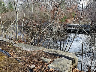
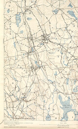
The Matfield River is a 6.3-mile-long (10.1 km) river in Plymouth County, Massachusetts. It flows south through the town of East Bridgewater to a confluence with the Town River, forming the Taunton River. The Matfield River, where it flows through the historic village of Elmwood and flows under Route 18, is commonly known as the Elmwood River.

The Town River is a river in Plymouth County, Massachusetts, United States. It flows 10.6 miles (17.1 km) from the northeast end of Lake Nippenicket in the town of Bridgewater, flowing easterly through West Bridgewater, then south back into Bridgewater where it joins with the Matfield River to form the Taunton River.
The Winnetuxet River is a 12.1-mile-long (19.5 km) river in southeastern Massachusetts. It flows west from an unnamed pond near Cole Mill in Carver, through Plympton and Halifax, to the Taunton River.
The Rumford River is a small river in southeastern Massachusetts, United States, that is a tributary of the Threemile River in the Taunton River watershed. The Rumford River, 23.1 kilometres (14.4 mi) long, begins within the town of Foxborough and flows south through Mansfield to the Norton Reservoir, within the town of Norton, then continues to its confluence with the Wading River to form the Threemile River.

The Jones River is a 7.5-mile-long (12.1 km) river running through Kingston, Massachusetts. The river drains about 30 square miles (78 km2), has its source in Silver Lake and drains into Kingston Bay. Land surrounding the river is 52% forested, of which 22% has been developed for residential use. There is a USGS stream gauge along 16 square miles (41 km2) of the river and it has measured the flow at 0.7 cubic feet per second (0.020 m3/s) per square mile of drainage area.
The Bungay River is a short river in southeastern Massachusetts that is a tributary of the Ten Mile River.

The Quashnet River, also known as Quoshnet River or Moonakis River, is a 5.1-mile-long (8.2 km) estuary in Falmouth, Massachusetts on Cape Cod. Its area is about 1-square-mile (2.6 km2).
The Childs River, also known as Child's River, is a 5.1-mile-long (8.2 km) river near Falmouth, Massachusetts on Cape Cod. Its drainage area is about 1-square-mile (2.6 km2). It has been heavily impacted by the development of cranberry bogs in its upper reaches.
The Shumatuscacant River is an 8.8-mile-long (14.2 km) river running through Abington and Whitman, Massachusetts. It forms part of the Taunton River Watershed.

The Little Pamet River is a 1.5-mile-long (2.4 km) river in Truro, Massachusetts on Cape Cod.

The Wankinco River is a 7.3-mile-long (11.7 km) river in eastern Massachusetts, United States. It is a tributary of the Wareham River, which drains into Buzzards Bay.
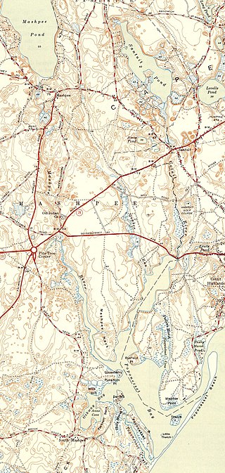
The Santuit River, also known as the Cotuit River, is a 2.3-mile-long (3.7 km) river on the border between Mashpee and Cotuit, Massachusetts on Cape Cod.

The Pocasset River is a small tidal river and estuary on the eastern shore of Buzzards Bay, in Bourne, Massachusetts, United States. It is located between the villages of Monument Beach and Pocasset along the western coast of Cape Cod. The river flows westward through a series of small ponds and wetlands, with a total length of about 2 miles (3.2 km).

The Weweantic River is a 17.0-mile-long (27.4 km) river in southeastern Massachusetts. Its name means "crooked" or "wandering stream" in the Wampanoag language.
The Fairhaven Branch Railroad was a short-line railroad in Massachusetts. It ran from West Wareham on the Cape Cod main line of the Old Colony Railroad, southwest to Fairhaven, a town across the Acushnet River from New Bedford.

Leonards Pond, also known as Leonard's Pond, is a 54-acre (220,000 m2) pond in Rochester, Massachusetts. The pond is located west of Mary's Pond. The confluence of the west and east branches of the Sippican River is at this pond, and the Sippican River continues as the outflow.
The East Over Reservation is a 75-acre (300,000 m2) nature preserve and working farm in Rochester, Massachusetts, USA, and is managed by the Trustees of Reservations. There are hiking trails, quarry-stone walls and a "treasure hunt", designed to test one's map reading skills. It was protected between 2003 and 2005.

Back River is a small tidal estuary in Bourne, Massachusetts on the eastern shore of Buzzards Bay. It lies just south of the Cape Cod Canal near the village of Monument Beach. It is separated from Buzzards Bay by Phinneys Harbor. The river's length is 2.1 miles (3.4 km).

