Poor Meadow Brook

Last updated
Poor Meadow Brook
Country United States
Physical characteristics
Main source Wetland near Route 14 in Hanson
River mouth Satucket River
Length 5.8 miles (9.3 km)

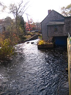
Poor Meadow Brook is a 5.8-mile-long (9.3 km) [1] stream within the Taunton River Watershed in southeastern Massachusetts. The stream runs from a wetland near County Street (the eastern crossing of Route 14) in Hanson to the confluence with the Satucket River in East Bridgewater.

Taunton River Watershed

The Taunton River watershed or Taunton River basin is made up of 562 square miles (1,500 km2) of rivers, lakes, ponds, streams, and wetlands in southeastern Massachusetts, USA. It is the second largest watershed in the state. Also, it is a significant part of a much larger multi-state watershed, the Narragansett Bay watershed.

Massachusetts State of the United States of America

Massachusetts, officially the Commonwealth of Massachusetts, is the most populous state in the New England region of the northeastern United States. It borders on the Atlantic Ocean to the east, the states of Connecticut and Rhode Island to the south, New Hampshire and Vermont to the north, and New York to the west. The state is named after the Massachusett tribe, which once inhabited the east side of the area, and is one of the original thirteen states. The capital of Massachusetts is Boston, which is also the most populous city in New England. Over 80% of Massachusetts's population lives in the Greater Boston metropolitan area, a region influential upon American history, academia, and industry. Originally dependent on agriculture, fishing and trade, Massachusetts was transformed into a manufacturing center during the Industrial Revolution. During the 20th century, Massachusetts's economy shifted from manufacturing to services. Modern Massachusetts is a global leader in biotechnology, engineering, higher education, finance, and maritime trade.

Wetland A land area that is permanently or seasonally saturated with water

A wetland is a distinct ecosystem that is inundated by water, either permanently or seasonally, where oxygen-free processes prevail. The primary factor that distinguishes wetlands from other land forms or water bodies is the characteristic vegetation of aquatic plants, adapted to the unique hydric soil. Wetlands play a number of functions, including water purification, water storage, processing of carbon and other nutrients, stabilization of shorelines, and support of plants and animals. Wetlands are also considered the most biologically diverse of all ecosystems, serving as home to a wide range of plant and animal life. Whether any individual wetland performs these functions, and the degree to which it performs them, depends on characteristics of that wetland and the lands and waters near it. Methods for rapidly assessing these functions, wetland ecological health, and general wetland condition have been developed in many regions and have contributed to wetland conservation partly by raising public awareness of the functions and the ecosystem services some wetlands provide.

Related Research Articles

Jones River river in the United States of America

The Jones River is a 7.5-mile-long (12.1 km) river running through Kingston, Massachusetts. The river drains about 30 square miles (78 km2), has its source in Silver Lake and drains into Kingston Bay. Land surrounding the river is 52% forested, of which 22% has been developed for residential use. There is a USGS stream gauge along 16 square miles (41 km2) of the river and it has measured the flow at 0.7 cubic feet per second (0.020 m3/s) per square mile of drainage area.

Kosmosdale is a neighborhood in southwestern Louisville, Kentucky located along Dixie Highway near Depot Lane and is named after the Kosmos Cement Company. The Kosmos Cement Company was purchased by the Flintkote Corporation in 1957 and operated as a Division of Flintkote for many years. It is now operated by Cemex, Inc. as a joint venture.

Elbow Pass

Elbow Pass is the mountain pass between the Highwood and Elbow areas in Kananaskis Country, Alberta, Canada. It contains Elbow Lake which is the headwaters of the Elbow River.

The Drakes River is a 2.1-mile (3.4 km) long stream located in southeastern New Hampshire in the United States. It is a tributary of the Taylor River, a tidal inlet of the Atlantic Ocean.

The Old River is a 3.1-mile (5.0 km) long stream located in southeastern New Hampshire in the United States. It is a tributary of the Taylor River, the primary tributary of the Hampton River estuary connected to the Atlantic Ocean.

The Egypt River is a stream in Ipswich, Massachusetts, United States.

Rowley River river in the United States of America

The Rowley River is a small river between Ipswich and Rowley, Massachusetts.

The Whitefish River is an 11.9-mile-long (19.2 km) river on the Upper Peninsula of the U.S. state of Michigan. The mouth of the river is in Delta County at 45°54′34″N86°58′01″W on the Little Bay De Noc of Lake Michigan. The main branch of the river is formed by the confluence of the east and west branches at 46°03′25″N86°52′17″W.

Nazas River river in Mexico

The Nazas River is a river located in northern Mexico, in territory of the states of Coahuila and Durango. It is part of the endorheic Bolsón de Mapimí. It is only 560 kilometres (350 mi) long, but irrigates an area of 71,906 km² in the middle of the desert. The Nazas is also nurtured by the San Juan, Ramos, Potreritos, del Oro, Nazas, Santiago, Tepehuanes and Peñón Blanco rivers. The river starts at the Sierra Madre Occidental. Tiahualilo is an aboriginal title for this stream, and seems not ill fitting to it when one of its mighty torrents is in flow.

Buffalo Point First Nation is an Ojibwa or Saulteaux band government located in southeastern corner of Manitoba, along the shores of Lake of the Woods. It is bordered largely by the unorganized portion of Division No. 1, Manitoba. It also has smaller borders with the Rural Municipality of Piney, as well as the northeast corner of Roseau County, Minnesota. The main settlement of Buffalo Point is located at 49°00′40″N95°14′20″W.

Czachów, Świętokrzyskie Voivodeship Village in Świętokrzyskie, Poland

Czachów is a village in the administrative district of Gmina Ożarów, within Opatów County, Świętokrzyskie Voivodeship, in south-central Poland. It lies approximately 4 kilometres (2 mi) north-east of Ożarów, 23 km (14 mi) north-east of Opatów, and 77 km (48 mi) east of the regional capital Kielce.

The South Branch Dead River is a 26.3-mile-long (42.3 km) tributary of the Dead River in Franklin County, Maine.

The West Branch Carrabassett River is a short tributary of the Carrabassett River in Franklin County, Maine. From the confluence of Quick Stream with a small stream in Salem, the river runs 11.1 miles (17.9 km) northeast to its mouth in Kingfield.

Margance (Vranje) Village in Pčinja District, Serbia

Margance is a village in the municipality of Vranje, Serbia. According to the 2002 census, the village has a population of 20 people.

Weir River (Massachusetts) river in the United States of America

Weir River is a short stream and estuary that empties into Hingham Bay, part of Boston Harbor in Massachusetts, United States. The name is attributed to the location of a fishing weir in the stream. The river gives its name to a larger watershed and Weir River Farm, a park and nature reserve owned by The Trustees of Reservations.

Another River is a stream in Kenai Peninsula Borough, Alaska, in the United States.

Slims River watercourse in Canada

The Slims River was a glacially fed river in the Canadian territory of Yukon. Until 2016, it originated in the Kaskawulsh Glacier, then ran approximately 15 mi (24 km) into the southern terminus of Kluane Lake.

Arapahoe Creek is a stream in Andrew and Nodaway counties of northwest Missouri. It is a tributary to the Nodaway River.

Woolsey Creek is a stream in Camden and Laclede counties the Ozarks of south central Missouri. Woolsey Creek is a tributary to the Niangua River. The stream enters the Niangua just upstream (south) of Lake Niangua.

Honey Creek is a stream in the U.S. state of Iowa. It is a tributary to the Des Moines River.

References

  1. U.S. Geological Survey. National Hydrography Dataset high-resolution flowline data. The National Map, accessed April 1, 2011

Coordinates: 42°00′40″N70°54′34″W / 42.01111°N 70.90944°W / 42.01111; -70.90944

Geographic coordinate system Coordinate system

A geographic coordinate system is a coordinate system that enables every location on Earth to be specified by a set of numbers, letters or symbols. The coordinates are often chosen such that one of the numbers represents a vertical position and two or three of the numbers represent a horizontal position; alternatively, a geographic position may be expressed in a combined three-dimensional Cartesian vector. A common choice of coordinates is latitude, longitude and elevation. To specify a location on a plane requires a map projection.