Taunton is a city in Bristol County, Massachusetts, United States. It is the seat of Bristol County. Taunton is situated on the Taunton River which winds its way through the city on its way to Mount Hope Bay, 10 miles (16 km) to the south. At the 2010 census, the city had a population of 55,874. Shaunna O'Connell is the mayor of Taunton.

Halifax is a town in Plymouth County, Massachusetts, United States. The population was 7,518 at the 2010 census.

Lakeville is a town in Plymouth County, Massachusetts, United States. The population was 10,602 at the 2010 census.
Middleborough is a town in Plymouth County, Massachusetts, United States. The population was 23,116 at the 2010 census.

Bridgewater is a city located in Plymouth County, in the state of Massachusetts, United States. As of the 2010 U.S. Census, the city's population was 26,563. Bridgewater is located approximately 25 miles (40 km) south of Boston and approximately 35 miles east of Providence, Rhode Island.

The Three Mile River or Threemile River is a river in Bristol County, Massachusetts. It is formed by the junction of the Rumford and Wading rivers in the town of Norton. It flows in a southeasterly direction for 13.5 miles (21.7 km) through the towns of Norton, Taunton and Dighton, where it joins the Taunton River.
Route 140 is a 107.76-mile-long (173.42 km) state highway which passes through parts of southeastern and central Massachusetts. The highway follows a southeast-northwest trajectory, running from U.S. Route 6 in New Bedford just north of Buzzards Bay northwest to an intersection with Route 12 in Winchendon, a few miles south of the border with New Hampshire.

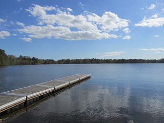
Watson Pond is a small freshwater lake within Watson Pond State Park, in Taunton, Massachusetts, United States. The lake is connected to Lake Sabbatia and much of its coastline is forested. The lake is open to the public for swimming and ice fishing.

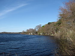
Lake Sabbatia, sometimes known as Scaddings Pond is a 248-acre great pond in Taunton, Massachusetts, near Watson Pond State Park. The lake is where Mill River begins and the Snake River ends. It is the largest lake in the city of Taunton and the most popularly used. There are several coves and an island within the lake. Parts of its coastline are populated with woods, streets, and residential homes. Lake Sabbatia is used for a variety of recreational activities such as boating, swimming, fishing, and ice fishing. There is a boat ramp off Bay Street into the lake.
The Hockomock Swamp is a vast wetland encompassing much of the northern part of southeastern Massachusetts. This 16,950-acre (6,859 ha) land is considered the largest freshwater swamp in the state. It acts as a natural flood control mechanism for the region.

The South Coast of Massachusetts is the region of southeastern Massachusetts consisting of southern Bristol and Plymouth counties bordering Buzzards Bay, and includes the cities of Fall River, New Bedford, the southeastern tip of East Taunton and nearby towns. The term is recent, dating to the 1990s, and sometimes confused with the South Shore.
The Quequechan River is a river in Fall River, Massachusetts, that flows in a northwesterly direction from the northwest corner of the South Watuppa Pond through the heart of the city of Fall River and into the end of the Taunton River at Mount Hope Bay at Heritage State Park/Battleship Cove. The word Quequechan means "Falling River" or "Leaping/Falling Waters" in Wampanoag, hence the city's name.

Quaboag Pond is a 537-acre (2.17 km2) pond located near the East Brookfield and Brookfield, Massachusetts. The pond lies about two miles (3 km) south of state Route 9 as it passes through East Brookfield. Quaboag Pond was once named Podunk Pond.
Southeastern Massachusetts consists of those portions of Massachusetts located along Buzzards Bay, including the cities of New Bedford and Fall River and their respective suburbs. Despite the location of Cape Cod and the islands to its south, which are the southeasternmost parts of the state, they are not always grouped in this designation. At its broadest definition, it includes all of Massachusetts south of Boston and southeast of Worcester.
Monponsett Pond, also called Monponsett Lake and the Twin Lakes, originally one lake is dissected by route 58 into a system of two ponds, West and East, mostly in Halifax, Massachusetts, with a small portion of West Monponsett Pond extending into Hanson. The western basin is 282 acres (1.14 km2), and the eastern basin is 246 acres (1.00 km2). The average depth of both ponds is seven feet and the maximum depth is 13 feet (4.0 m). The outflow is Stump Brook, a tributary of Poor Meadow Brook, in the northwestern part of West Monponsett Pond. The pond is part of the Taunton River Watershed. Occasionally during water shortages water from this pond is diverted into Silver Lake, the principal water supply for the City of Brockton.

Winnecunnet Pond or Winneconnet Pond or Winnecunnett Pond, very often called Lake Winnecunnet or Lake Winneconnet or Lake Winnecunnett although it is a pond rather than a lake, is a body of water in Norton, Massachusetts, United States.

Lake Massapoag is a 353-acre (1.43 km2), natural, springfed lake located in Sharon, Massachusetts. The name Massapoag is Algonquin, meaning "large water".

North Taunton is an unofficial neighborhood in the city of Taunton, Massachusetts. It is not a census-designated area, but is considered by local residents as a municipally designated populated region of the city.

Bay Road is a 17.2-mile (27.7 km) north-south road in southeastern Massachusetts. The road is in parts a very old road, dating to colonial times, when it was known as the King's Highway.

Oxbow National Wildlife Refuge is a property of the United States National Wildlife Refuge (NWR) system located in Middlesex and Worcester counties in Massachusetts. It was founded in 1974.