
Wakefield is a town in Carroll County, New Hampshire, United States. The population was 5,078 at the 2010 census. The town includes the villages of Wakefield Corner, East Wakefield, North Wakefield, Sanbornville, Union, Woodman and Province Lake. Wakefield Corner, popular with tourists, is a picturesque hilltop village of antique buildings. The state of Maine is on the eastern border of Wakefield.

Pine Plains is a hamlet and census-designated place (CDP) in Dutchess County, New York, United States. The population was 1,353 at the 2010 census. It is part of the Poughkeepsie–Newburgh–Middletown, NY Metropolitan Statistical Area as well as the larger New York–Newark–Bridgeport, NY-NJ-CT-PA Combined Statistical Area.

The Conecuh National Forest in southern Alabama covers 83,000 acres (340 km2), along the Alabama - Florida line in Covington and Escambia counties. Topography is level to moderately sloping, broad ridges with stream terraces and broad floodplains.
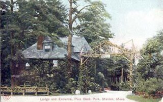
Pine Banks is a 107.5-acre (0.435 km2) park located in the cities of Malden and Melrose, Massachusetts. It was donated by former Mayor of Malden Elisha S. Converse to be used "forever as a public park". The agreement was that both towns had equal ownership, responsibility, and power, which is still the case today; the non–profit Board of Trustees owns the park, with equal representation from both cities.

North Triangle Pond is a 20-acre (81,000 m2) shallow pond in the West Plymouth section of Plymouth, Massachusetts, east of the Route 80 terminus off Samoset Street. The average water depth of the pond is less than one meter. The water quality is impaired due to non-native aquatic plants and nuisance exotic species. North Triangle Pond is also home to the endangered Northern Red-Bellied Cooter.
Beaver Dam Pond is a 30-acre (120,000 m2) pond in the Manomet section of Plymouth, Massachusetts. The pond is located north of Little Island Pond, west of Fresh Pond, and east of the Pine Hills. The pond is the headwaters of Beaver Dam Brook. The water quality may be impaired due to discharge from developments in the watershed. Non-native plants in the watershed are being managed by the owners.
Fuller Street Pond is a 21-acre (85,000 m2) pond in Carver and Middleborough, Massachusetts. The pond gets its name from the name of the street along the pond's northern shore on the Carver side. The street name on the Middleborough side is Stone Street. The water quality is impaired due to non-native aquatic plants and non-native fish.
Crossman Pond is a 15-acre (61,000 m2) pond in Kingston, Massachusetts, located off Wapping Road and South Street. The pond is hydro logically associated with a cranberry bog operation located to the west of the pond. The outflow is an unnamed stream that feeds the cranberry bog, ultimately leading to Fountainhead Brook, a tributary of the Jones River. The water quality is impaired due to non-native aquatic plants.
Harrobs Corner Bog Pond is a 16-acre (65,000 m2) pond in Plympton, Massachusetts. The pond is located in the North Plympton section of the town north of Harrobs Corner off Route 106 and Lake Street, and south of Silver Lake village. The pond is hydrologically associated with a cranberry bog operation located to the northeast of the pond. An unnamed brook heading south toward Jones River Creek, a tributary of the Jones River, is the outflow of the pond. The water quality is impaired due to non-native aquatic plants in the pond.
Pine Lake is a 23-acre (93,000 m2) lake in Duxbury, Massachusetts in the village of Tinkertown. The lake is located southwest of Round Pond, northwest of Island Creek Pond, and east of Route 3 near the East Street underpass. The outflow is a small stream that flows into Round Pond. A small subdivision lies along the southern shore of the lake.
Island Creek Pond is a 43-acre (170,000 m2) pond in Duxbury, Massachusetts in the village of Tinkertown. The pond is located north of Mill Pond, south of North Hill Marsh Pond, and southwest of Pine Lake and Round Pond. The pond is the headwaters to Island Creek. The water quality is impaired due to non-native aquatic plants and non-native fish in the pond. Crocker Park, an open space area owned by the Town of Duxbury, is situated along the southern shore of the pond.
Lower Chandler Pond is a 30-acre (120,000 m2) pond in Duxbury and Pembroke, Massachusetts. The pond is located north of Reeds Millpond and south of Upper Chandler Pond. Pine Brook, a tributary of the Jones River, flows through the pond. The water quality has been impaired by non-native aquatic plants and non-native fish in the pond.
Pine Street Pond is a 17-acre (69,000 m2) pond in Duxbury, Massachusetts. The pond is located southeast of Lower Chandler Pond and northeast of Reeds Millpond. The water quality is impaired due to non-native aquatic plants in the pond. The pond is hydrologically associated with a cranberry bog operation located to the west of the pond. An unnamed brook heading west through the cranberry bog and ultimately leading to Pine Brook is the outflow of the pond.
Pembroke Street South Pond is a 16-acre (65,000 m2) pond in Kingston, Massachusetts. The pond is located on Route 27 northwest of the intersection with Winter Street and Reed Street, south of Reeds Millpond. Pine Brook, a tributary of the Jones River, flows through the pond. The water quality is impaired due to non-native aquatic plants and non-native fish in the pond.
Russell Pond is a 14-acre (57,000 m2) pond in Kingston, Massachusetts. The pond is located northeast of Indian Pond off Route 80. The pond is the headwaters to Furnace Brook, a tributary of the Jones River. The water quality is impaired due to non-native aquatic plants and non-native fish in the pond.

Jacobs Pond is a 59-acre (240,000 m2) pond in Norwell, Massachusetts. The pond is located alongside Assinippi, a village in neighboring Hanover. Route 123 runs along the southern shore of the pond. The pond is the headwaters of Third Herring Brook, a tributary of the North River which is the town line between Norwell and the eastern boundary of Hanover. The water quality is impaired due to non-native aquatic plants and non-native fish in the pond. The South Shore Natural Science Center is located near this pond.
North Hill Marsh Pond is a 38-acre (150,000 m2) pond in Duxbury, Massachusetts, USA. The pond is the headwaters to the Back River. The pond is located northeast of Round Pond and north of Island Creek Pond. A wildlife sanctuary borders this pond to the south, and the North Hill Country Club, accessible via Merry Avenue, off Route 14, borders this pond to the northeast. The water quality is impaired due to non-native aquatic plants in the pond.
Upper Chandler Pond is a 10-acre (40,000 m2) pond in Duxbury and Pembroke, Massachusetts. The pond is located north of Lower Chandler Pond and east of West Chandler Pond. The pond is the headwaters to Pine Brook, a tributary of the Jones River. The pond is hydro logically associatied with two nearby cranberry bogs. The water quality is impaired due to non-native aquatic plants and non-native fish in the pond.

Coles Brook is a small stream that begins east of Pine Street in Rehoboth MA, and flows in a southwest direction to Central Pond and the James V. Turner Reservoir and the on the border of Seekonk, Massachusetts and East Providence, Rhode Island. It is a tributary of the Ten Mile River.
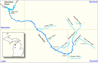
The Pine River, formerly known as the South Branch Manistee River, is a 53.6-mile-long (86.3 km) tributary of the Manistee River in the U.S. state of Michigan. It forms at the confluence of the North Branch and East Branch of the Pine River in northwest Osceola County, flows southwest, then west and north through the northeast corner of Lake County and into southwest Wexford County, emptying into the Tippy Dam Pond on the Manistee River in Manistee County. The Pine River watershed drains an area of 265 square miles (690 km2).
