
North Andover is a town in Essex County, Massachusetts, United States. At the 2020 census the population was 30,915.

Wilmot is a town in Merrimack County, New Hampshire, United States. The population was 1,407 at the 2020 census. The town includes the communities of Wilmot, Wilmot Flat, and North Wilmot.

Prince Albert National Park encompasses 3,874 square kilometres (1,496 sq mi) in central Saskatchewan, Canada and is located 200 kilometres (120 mi) north of Saskatoon. Though declared a national park March 24, 1927, official opening ceremonies weren't performed by Prime Minister William Lyon Mackenzie King until August 10, 1928. This park is open all year but the most visited period is from May to September. Although named for the city of Prince Albert, the park's main entrance is actually 80 km (50 mi) north of that city via Highways 2 and 263, which enters the park at its southeast corner. Two additional secondary highways enter the park, Highway 264, which branches off Highway 2 just east of the Waskesiu townsite, and Highway 240, which enters the park from the south and links with 263 just outside the entry fee-collection gates. Prince Albert National Park is not located within any rural municipality, and is politically separate from the adjacent Northern Saskatchewan Administration District (NSAD).
Cachuma Lake is a reservoir in the Santa Ynez Valley of central Santa Barbara County, California on the Santa Ynez River adjoining the north side of California State Route 154. The artificial lake was created by the construction of Bradbury Dam, a 201 ft (61 m) earth-fill structure built by the U.S. Bureau of Reclamation in 1953. Its surface area covers 3,100 acres (1,300 ha), with a maximum design capacity of 205,000 acre⋅ft (253,000,000 m3), but it is currently limited to 188,000 acre⋅ft (232,000,000 m3) due to sediment accumulation. As of May 23, 2019, it is at 80.8% of capacity.

Silver Lake, formerly known as Long Pond, is a small lake in the town of Hollis, New Hampshire, United States. The lake was formerly surrounded by summer vacation cottages and camps, but most of these buildings have now been converted for use as year-round homes. Silver Lake State Park occupies the northern end of the lakeshore.

Stevens Creek Reservoir is an artificial lake located in the foothills of the Santa Cruz Mountains near Cupertino, California. A 1,063-acre (430 ha) county park surrounds the reservoir and provides limited fishing, picnicking, hiking, and horseback riding activities. Although swimming is not allowed, non-power boating is allowed for certain parts of the year. No powered boats or jet skis are allowed. All vessels must be inspected for invasive Quagga mussels prior to launch.

Weir Hill Reservation is a 194-acre (0.79 km2) public park located in the town of North Andover, Massachusetts. The Trustees of Reservations owns and maintains the property.

Golden Ears Provincial Park is a Provincial park in British Columbia, Canada and is 555.9 square kilometres (214.6 sq mi). It is named after the prominent twin peaks which are commonly referred to as Golden Ears. The park's southern end is located on the northern edge of the district municipality of Maple Ridge on the north side of the Fraser River.

Lake Massabesic or Massabesic Lake is a lake in southern New Hampshire, United States, covering about 2,560 acres (1,040 ha) within the city of Manchester and the town of Auburn. Because it provides drinking water for Manchester, swimming and water skiing are not allowed there. Popular sports on the lake are sailing, fishing, and kayaking. The recreational trails along the lake provide views of the lake and the town of Auburn.
Ipswich River is a small river in northeastern Massachusetts, United States. It held significant importance in early colonial migrations inland from the ocean port of Ipswich. The river provided safe harborage at offshore Plum Island Sound to early Massachusetts subsistence farmers, who were also fishermen. A part of the river forms town boundaries and divides Essex County, Massachusetts on the coast from the more inland Middlesex County. It is 35 miles (56 km) long, and its watershed is approximately 155 square miles (401 km2), with an estimated population in the area of 160,000 people.

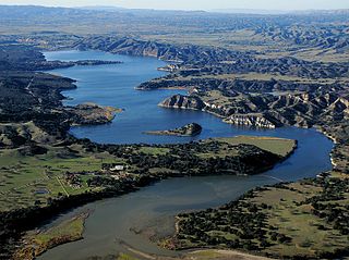
Lake San Antonio is a lake located primarily in southern Monterey County, California, and partially in northern San Luis Obispo County, California. The lake is formed by San Antonio Dam on the San Antonio River. The dam is 202 feet tall and was completed in 1965 under Monterey County District Engineer Loran Bunte Jr. The lake and dam are owned by the Monterey County Water Authority. The lake has a capacity of 350,000 acre-feet (430,000,000 m3).

Folsom Lake is a reservoir on the American River in the Sierra Nevada foothills of California, United States.
Lake Perris is an artificial lake completed in 1973. It is the southern terminus of the California State Water Project, situated in a mountain-rimmed valley between Moreno Valley and Perris, in what is now the Lake Perris State Recreation Area. The park offers a variety of recreational activities. Because of this and the lake's proximity to major population centers, it is very crowded during the summer months.

Lake Natoma is a small lake in the western United States, along the lower American River, between Folsom and Nimbus Dams in Sacramento County, California. The lake is located within the Folsom Lake State Recreation Area which is responsible for maintaining the facilities and bike trails surrounding the lake. Lake Natoma is located 15 miles east of Sacramento, and has 500 surface acres of water. The total length of lake Natoma is 4 miles.
The Cochichewick River, also known as Cochichewick Brook, is a 1.6-mile-long (2.6 km) stream in North Andover, Massachusetts, that drains water from Lake Cochichewick into the Merrimack River.

The San Pablo Reservoir is an open cut terminal water storage reservoir owned and operated by the East Bay Municipal Utility District (EBMUD). It is located in the valley of San Pablo Creek, north of Orinda, California, United States, and south of El Sobrante and Richmond, east of the Berkeley Hills between San Pablo Ridge and Sobrante Ridge.

Coyote Lake is an artificial lake in Santa Clara County, California, between Morgan Hill and Gilroy.
Balsam Lake Provincial Park is a provincial park located in south-central Ontario on Balsam Lake. The park is situated along the Trent-Severn Waterway, a few kilometres southwest of Coboconk. It is an all-seasons recreation area offering camping, boating and fishing, and while closed in winter it is also used for skiing and snowshoeing.

Anderson Lake, also known as Anderson Reservoir, is an artificial lake in Morgan Hill, located in southern Santa Clara County, California. The reservoir is formed by the damming of Coyote Creek just below its confluence with Las Animas Creek. A 4,275-acre (1,730 ha) county park surrounds the reservoir and provides limited fishing, picnicking, and hiking activities. Although swimming is prohibited, boating, water-skiing and jet-skiing are permitted in the reservoir.

The Merrimack Valley is a bi-state region along the Merrimack River in the U.S. states of New Hampshire and Massachusetts. The Merrimack is one of the larger waterways in New England and has helped to define the livelihood and culture of those living along it for millennia.


