
Saco Bay is a small curved embayment of the Gulf of Maine on the Atlantic coast of Maine in the United States. The name derives "from a map of the coastline made in 1525 by the Spanish explorer Esteban Gómez. He named the bay Bahio de Saco ."
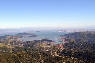
Richardson Bay is a shallow, ecologically rich arm of San Francisco Bay, managed under a Joint Powers Agency of four northern California cities. The 911-acre (369 ha) Richardson Bay Sanctuary was acquired in the early 1960s by the National Audubon Society. The bay was named for William A. Richardson, early 19th century sea captain and builder in San Francisco.
Ipswich River is a small river in northeastern Massachusetts, United States. It held significant importance in early colonial migrations inland from the ocean port of Ipswich. The river provided safe harborage at offshore Plum Island Sound to early Massachusetts subsistence farmers, who were also fishermen. A part of the river forms town boundaries and divides Essex County, Massachusetts on the coast from the more inland Middlesex County. It is 35 miles (56 km) long, and its watershed is approximately 155 square miles (401 km2), with an estimated population in the area of 160,000 people.

Oyster Pond River, also called Oyster Creek, is a 1.7-mile-long (2.7 km) river in Chatham, Massachusetts on Cape Cod.

The Daniel Webster Wildlife Sanctuary is a sanctuary owned by the Massachusetts Audubon Society, the largest conservation organization in New England, in the town of Marshfield, Massachusetts. The sanctuary, formerly the farm of Edward Dwyer, statesman Daniel Webster and the William Thomas family of Marshfield, the first English landowner to live on the sanctuary land, was purchased by Mass Audubon in 1984 thanks to the volunteer efforts of the Committee for the Preservation of Dwyer Farm for the People of Marshfield. The sanctuary contains 507 acres (2.1 km2) of mixed cultural grasslands, red maple swamps, a five-tiered wet panne, Webster Pond and a section of the Green Harbor River. It is the site of the annual Daniel Webster Farm Day celebration. Surrounding lands owned by the town of Marshfield and the Marshfield Airport increase the local open space area to more than 1000 acres (4 km2).

The Massachusetts Audubon Society, founded in 1896 by Harriet Hemenway and Minna B. Hall, headquartered in Lincoln, Massachusetts, is a nonprofit organization dedicated to "protecting the nature of Massachusetts". Mass Audubon is independent of the National Audubon Society, and was founded earlier. Mass Audubon protects 36,500 acres of land throughout Massachusetts, saving birds and other wildlife, and making nature accessible to all with its wildlife sanctuaries and 20 nature centers.

The Brooks Woodland Preserve is a 558-acre (226 ha) open space preserve located in Petersham, Massachusetts. The property, named after industrialist and dipolomat James Willson Brooks, is managed by the land conservation non-profit organization The Trustees of Reservations and offers 13 miles (21 km) of trails and primitive woods roads available for hiking, horseback riding, and cross country skiing. Second growth forest, overgrown farm fields, granite ledges, historic stone walls, creeks, and rolling hills characterize the preserve.
Pine Lake is a 23-acre (93,000 m2) lake in Duxbury, Massachusetts in the village of Tinkertown. The lake is located southwest of Round Pond, northwest of Island Creek Pond, and east of Route 3 near the East Street underpass. The outflow is a small stream that flows into Round Pond. A small subdivision lies along the southern shore of the lake.
Island Creek Pond is a 43-acre (170,000 m2) pond in Duxbury, Massachusetts in the village of Tinkertown. The pond is located north of Mill Pond, south of North Hill Marsh Pond, and southwest of Pine Lake and Round Pond. The pond is the headwaters to Island Creek. The water quality is impaired due to non-native aquatic plants and non-native fish in the pond. Crocker Park, an open space area owned by the Town of Duxbury, is situated along the southern shore of the pond.
Lower Chandler Pond is a 30-acre (120,000 m2) pond in Duxbury and Pembroke, Massachusetts. The pond is located north of Reeds Millpond and south of Upper Chandler Pond. Pine Brook, a tributary of the Jones River, flows through the pond. The water quality has been impaired by non-native aquatic plants and non-native fish in the pond.

Mill Pond is a 13-acre (53,000 m2) pond in Duxbury, Massachusetts in the village of Island Creek. The pond is located south of Island Creek Pond. Island Creek runs through the pond. Route 3A runs along the southern shore of the pond. The water quality is impaired due to non-native aquatic plants in the pond. The fishway at the Mill Pond dam has deteriorated and no longer functions.
Pine Street Pond is a 17-acre (69,000 m2) pond in Duxbury, Massachusetts. The pond is located southeast of Lower Chandler Pond and northeast of Reeds Millpond. The water quality is impaired due to non-native aquatic plants in the pond. The pond is hydrologically associated with a cranberry bog operation located to the west of the pond. An unnamed brook heading west through the cranberry bog and ultimately leading to Pine Brook is the outflow of the pond.

The Bay Circuit Trail and Greenway or Bay Circuit is a Massachusetts recreational trail and greenway connecting the outlying suburbs of Boston from Plum Island in Newburyport to Kingston Bay in Duxbury, a distance of 200 miles (320 km).
Berry Mountain, east peak 2,203 feet (671 m) and west peak 2,188 feet (667 m), is a prominent mountain in the Taconic Mountains of western Massachusetts. The mountain is located in Pittsfield State Forest. The west peak is traversed by the 35 mi (56 km) Taconic Crest hiking trail and the east peak is traversed by the 12.1 mi (19.5 km) multi-use Taconic Skyline Trail. The summits are mostly wooded with northern hardwood forest species, but also support a 65-acre (260,000 m2) field of wild azaleas. A microwave tower stands on the east peak. A park loop automobile road and a campground, maintained for summer use, are located just to the north of the summits. Berry Pond, 2,150 feet (660 m), presumed the highest natural pond in the state of Massachusetts, is located on the ridge between Berry Mountain and Berry Hill to the north.

The Connecticut Audubon Society Center at Fairfield is a nature center and wildlife sanctuary in the Greenfield Hill area of Fairfield, Connecticut. Constructed in 1971, the center features classrooms for environmental education programs, live animals on display, natural history exhibits, a nature library, a solar greenhouse and a gift shop. Outside there is a compound with non-releasable rescued birds of prey, including owls, hawks, peregrine falcons, a turkey vulture and other raptors.

Yokun Ridge is a ridge in the Taconic Mountains in Berkshire County, Massachusetts, consisting of a well-defined series of contiguous peaks including West Stockbridge Mountain and Lenox Mountain. The name "Yokun Ridge" was invented for the area in 1971 by a land conservation and environmental advocacy organization called the Berkshire Natural Resources Council, and was accepted in 2009 by the United States Board on Geographic Names. Yokun Ridge is 9 miles (14 km) long and contains a conservation planning area called the Stockbridge-Yokun Ridge Reserve designated in 1993 by the U.S. Forest Service under its Forest Legacy Program. The ridge is notable for outdoor recreation and scenic beauty, as well as its conserved land and proximity to the tourist destinations of Lenox and Stockbridge. Yokun Ridge is located within West Stockbridge, Stockbridge, Lenox, Richmond, and Pittsfield, Massachusetts. Approximately one-third of the ridge is protected as open space reserve, municipal watershed, and wildlife sanctuary.

The San Joaquin Wildlife Sanctuary is a 300 acres constructed wetland in Irvine, California, in the flood plain of San Diego Creek just above its outlet into the Upper Newport Bay.

Willard Pond is a small, protected lake in Antrim, New Hampshire, United States. The lake, located in southwestern New Hampshire, is about 108 acres (44 ha) in size with an average depth of 25 feet (7.6 m) and a maximum depth of 58 feet (18 m). No petroleum motors are allowed, and fly fishing is the only form of fishing allowed. It is part of the dePierrefeu Wildlife Sanctuary, which is owned by the New Hampshire Audubon Society. Because the pond and the land around it are part of the sanctuary, the shore is unable to be developed. Therefore, there are no buildings around the pond and there won't be in the foreseeable future. Willard is instead surrounded by extensive amounts of wilderness and hiking trails that lead around the pond and to the summits of Bald Mountain and Goodhue Hill. Willard is a popular fishing, boating and hiking destination, and it has become more popular with its mention in numerous magazines and newspapers. Swimming is not permitted per the town of Antrim

