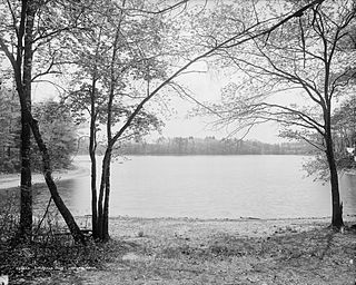
Walden Pond is a famous pond in Concord, Massachusetts, in the United States. A good example of a kettle hole, it was formed by retreating glaciers 10,000–12,000 years ago. The pond is protected as part of Walden Pond State Reservation, a 335-acre (136 ha) state park and recreation site managed by the Massachusetts Department of Conservation and Recreation. The reservation was designated a National Historic Landmark in 1962 for its association with the writer Henry David Thoreau (1817–1862), whose two years living in a cabin on its shore provided the foundation for his famous 1854 work, Walden; or, Life in the Woods. The National Historic Preservation Act of 1966 ensured federal support for the preservation of the pond.
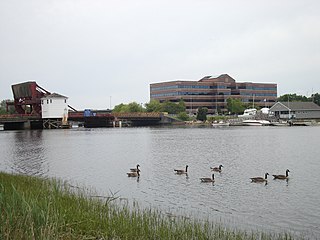
The Neponset River is a river in eastern Massachusetts in the United States. Its headwaters are at the Neponset Reservoir in Foxborough, near Gillette Stadium. From there, the Neponset meanders generally northeast for about 29 miles (47 km) to its mouth at Dorchester Bay between Quincy and the Dorchester section of Boston, near the painted gas tank.
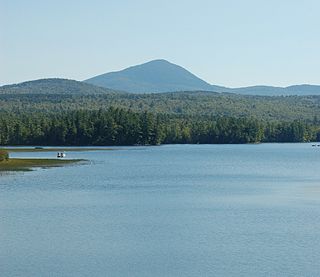
Mount Blue is a mountain in Maine, USA. It is a hiking destination with outstanding views from the observation deck of a tower at the summit. Its name is shared with Mount Blue State Park in Weld and Mount Blue High School in Farmington.

Blue Hills Reservation is a 7,000-acre (2,800 ha) state park in Norfolk County, Massachusetts in the United States. Managed by the Massachusetts Department of Conservation and Recreation, it covers parts of Milton, Quincy, Braintree, Canton, Randolph, and Dedham. Located approximately ten miles south of downtown Boston, the reservation is one of the largest parcels of undeveloped conservation land within the Greater Boston metropolitan area. The park's varied terrain and scenic views make it a popular destination for hikers from the Boston area.
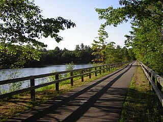
The Nashua River Rail Trail is a 12.5-mile (20.1 km) paved mixed-use rail trail in northern Massachusetts and southern New Hampshire under control of the Massachusetts Department of Conservation and Recreation (DCR). It roughly follows the course of the Nashua River, passing through the towns of Ayer, Groton, Pepperell, and Dunstable, Massachusetts and ends about a mile across the New Hampshire state border in Nashua, New Hampshire. The trail is used by walkers, cyclists, inline skaters, equestrians, and cross-country skiers.
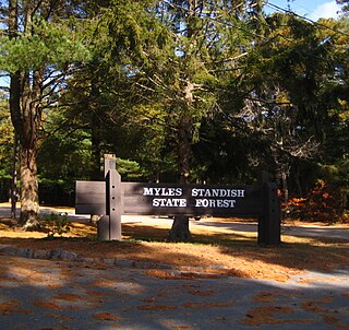
Myles Standish State Forest is a state forest located in the towns of Plymouth and Carver in southeastern Massachusetts, approximately 45 miles (70 km) south of Boston. It is the largest publicly owned recreation area in this part of Massachusetts and is managed by the Department of Conservation and Recreation (DCR).

Long Pond is a 211-acre (0.85 km2) cold water pond in Plymouth, Massachusetts, east of Myles Standish State Forest, Halfway Pond and Round Pond, west of Route 3 at Exit 3 and The Pinehills, northwest of Bloody Pond, and north of West Wind Shores. The pond has an average depth of 46 feet (14 m) and a maximum depth of 100 feet (30 m). It is fed by groundwater and an inlet from Little Long Pond, and drains through the pond bottom. A paved boat ramp provided by the Public Access Board with ample parking spaces is easily accessible from Route 3. The Pond has a 50 hp limitation on boating.

Connecticut River Greenway State Park is a protected environment with public recreation features that consists of separate state land holdings, including open spaces, parks, scenic vistas, and archaeological and historic sites, along the Connecticut River in the Pioneer Valley of western Massachusetts. The state park includes critical wildlife and plant habitat as well as areas providing public access to the river in its run across the state and is intertwined with other protected land including farmland under state-held agricultural preservation restrictions, municipal and conservation land trust holdings, and state and national wildlife refuges.
Fresh Pond is a 62-acre (250,000 m2) pond in the Manomet section of Plymouth, Massachusetts. The average depth is 12 feet (3.7 m) and the maximum depth is 30 feet (9.1 m). The southern shore of the pond is located in the Churchill Landing neighborhood, south of Manomet's business district and Manomet Bluffs, west of Fisherman's Landing, north of Cedar Bushes and Shallow Pond, and east of Beaver Dam Pond. Route 3A runs along the southeastern shore of the pond to its most southeastern point where it shoots away at a sharp curve known as the Brown Bear Curve, named after a defunct motel along the shore at that curve. A public beach, boat ramp, and a Native American burial site are located on the western shore of the pond on Bartlett Road, which has two intersections with Route 3A. The closer intersection is south of the Brown Bear Curve, while the other intersection is one mile (1.6 km) north, north of Manomet's business district. The pond is hydrologically associated with a cranberry bog operation located to the west of the pond. An unnamed brook heads west through the cranberry bog and ultimately leading to Beaver Dam Brook is the outflow of the pond.
Snipatuit Pond is a shallow 710-acre (2.9 km2) warm water pond in Rochester, Massachusetts. The average depth is five feet and the maximum depth is six feet, except for one very small nine foot hole near the pump station on the west shore. The pond is the headwaters of the Mattapoisett River. The inflow comes from two sources: Cedar Swamp, which is located to the northeast, and Great Quittacas Pond, which is connected to Snipatuit Pond and located to the northwest. The water quality is impaired due to wetlands vegetation. The boat access to the pond is a dirt ramp with limited parking located off Neck Road. Shoreline access is limited to the area east of the pond bordering Neck Road.
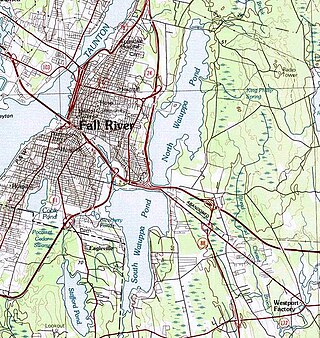
The Watuppa Ponds are two large, naturally occurring, spring-fed, glacially formed ponds located in Fall River and Westport, Massachusetts. Watuppa is a native word meaning "place of boats". The two ponds were originally one body of water, connected by a narrow rocky straight called "The Narrows" located on a thin strip of land between the two ponds which forms part boundary of between Fall River and Westport. The border between Fall River and Westport is also divided between the two ponds. Together, the ponds have an overall north–south length of about 7.5 miles, and have an average east–west width of about a mile. The ponds are drained by the Quequechan River, and flows in a westerly direction through the center of Fall River from South Watuppa Pond to Mount Hope Bay.
Higby Mountain or Mount Higby 892 feet (272 m), is a traprock mountain ridge located 3.75 miles (6.04 km) east of Meriden, Connecticut. It is part of the narrow, linear Metacomet Ridge that extends from Long Island Sound near New Haven, Connecticut, north through the Connecticut River Valley of Massachusetts to the Vermont border. Higby Mountain is known for its high cliff faces, unique microclimate ecosystems, and rare plant communities. It rises steeply 600 feet (180 m) above the Quinnipiac River valley and the city of Meriden to the west as a continuous 2-mile (3 km) long ledge. The mountain is traversed by the 50-mile (80 km) Mattabesett Trail.

The Taconic Crest Trail is a 37 mi (60 km) hiking trail in the Taconic Mountains in the northeastern United States. The trail extends from U.S. Route 20 in Hancock, Massachusetts, less than 1 mi (1.6 km) east of the New York border, north along the ridgecrest of the Taconic Range, first within Massachusetts, then weaving along the border of New York and Massachusetts and New York and Vermont, and ending in Petersburgh, New York, on NY Route 346, near the Vermont border. Much of the route has been conserved as state forest, conservation easement, or forest preserve.
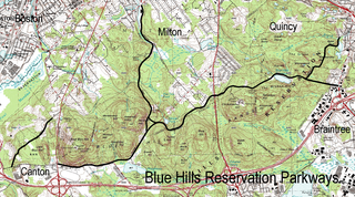
The Blue Hills Reservation Parkways are a network of historic parkways in and around the Blue Hills Reservation, a Massachusetts state park south of Boston, Massachusetts. It consists of six roadways that provide circulation within the park, and that join the park to two connecting parkways, the Blue Hills Parkway and the Furnace Brook Parkway. The roadway network was designed by Charles Eliot in the 1890s, except for Green Street, which was added to the network in the 1940s. The parkways were added to the National Register of Historic Places in 2003.

Spencer State Forest is a Massachusetts state forest and recreation reserve located in the town of Spencer, managed by the Massachusetts Department of Conservation and Recreation. The 92 mile (148 km) Midstate Trail passes through the state forest. The Commonwealth of Massachusetts also conducts logging in some parts of the property.

The Rock House Reservation is a 196-acre (79 ha) open space preserve located in West Brookfield, Massachusetts. The property, acquired in 1993 by the land conservation non-profit organization The Trustees of Reservations, is named for a natural rock shelter once used as a winter camp by Native Americans. Its location near two, long Native American footpaths suggests that it may also have been a trail camp and meeting place.

Harold Parker State Forest is a publicly owned forest with recreational features encompassing more than 3,300 acres (1,300 ha) in the towns of Andover, North Andover, North Reading, and Middleton, Massachusetts. Ponds, swamps, rolling hills, glacial erratics and rocky outcroppings can be found in the state forest, which features more than 35 miles (56 km) of backwoods roads and trails as well as remnants of 18th-century farming and milling operations. It is managed by the Massachusetts Department of Conservation and Recreation.

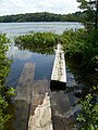
Fairyland Pond is a pond within Hapgood Wright Town Forest, a conservation area in Concord, Massachusetts. It is a popular recreation area, notable for its old-growth forest and its association with many literary figures from Concord’s past.

Willard Pond is a small, protected lake in Antrim, New Hampshire, United States. The lake, located in southwestern New Hampshire, is about 108 acres (44 ha) in size with an average depth of 25 feet (7.6 m) and a maximum depth of 58 feet (18 m). No petroleum motors are allowed, and fly fishing is the only form of fishing allowed. It is part of the dePierrefeu Wildlife Sanctuary, which is owned by the New Hampshire Audubon Society. Because the pond and the land around it are part of the sanctuary, the shore is unable to be developed. Therefore, there are no buildings around the pond and there won't be in the foreseeable future. Willard is instead surrounded by extensive amounts of wilderness and hiking trails that lead around the pond and to the summits of Bald Mountain and Goodhue Hill. Willard is a popular fishing, boating and hiking destination, and it has become more popular with its mention in numerous magazines and newspapers.