Abbreviation | AMC |
---|---|
Formation | 1876 |
Founder | Edward Charles Pickering |
Type | Non-governmental organization |
04-6001677 [1] | |
Legal status | 501(c)(3) charitable organization [1] |
Purpose | Environmental quality, protection, and beautification [1] |
Headquarters | 10 City Square, Boston, Massachusetts [2] |
Coordinates | 42°22′20″N71°03′42″W / 42.3723°N 71.0616°W |
Region | Northeastern United States and Mid-Atlantic United States |
Services | Environmental Education and Outdoor Survival Programs [1] |
Membership (2016) | 275,000 members, advocates, and supporters [3] |
Nicole Zussman [4] | |
Chair of the Board of Directors | Yvette Austin Smith [4] |
Publication | Appalachia |
Subsidiaries | AMC Maine Woods Initiative, LLC AMC MW Funding, LLC KI-Jo Mary, Inc. [5] |
Revenue (2017) | $33,070,020 [5] |
Expenses (2017) | $31,787,810 [5] |
Endowment (2018) | $60,863,607 [6] |
Staff (2017) | 807 [5] |
Volunteers (2017) | 16,000 [5] |
Website | outdoors |
Appalachian Mountain Club (AMC) is the oldest outdoor group in the United States. [7] Created in 1876 to explore and preserve the White Mountains in New Hampshire, it has expanded throughout the northeastern U.S., with 12 chapters stretching from Maine to Washington, D.C. The AMC's 100,000 members, its advocates, and supporters (as of 2023 [update] ) [3] mix outdoor recreation, particularly hiking and backpacking, with environmental activism. Additional activities include cross-country skiing, whitewater and flatwater canoeing and kayaking, sea kayaking, sailing, rock climbing and bicycle riding. The Club has about 2,700 volunteers, who lead roughly 7,000 trips and activities per year. The organization publishes a number of books, guides, and trail maps.
Appalachian Mountain Club was organized in 1876, incorporated in 1878, and authorized by legislative act of 1894 to hold mountain and forest lands as historic sites. [8] The club was formed by the efforts of Massachusetts Institute of Technology Professor Edward Charles Pickering and Samuel Hubbard Scudder, [9] who invited fellow Boston academics and vacationers to form a group interested in mountain exploration. The club aims to preserve the beauty of mountain forests, waters, historic sites and resorts; to render them attractive to visitors and excursionists; to publish accurate maps thereof; and to collect scientific data concerning the mountains. [8] [10] The group helped map the White Mountains and in 1888 built the first of eight High Huts in the range, modeled on Alpine shelters.
Though it's the oldest mountain club in America, the AMC was preceded by the Rocky Mountain Club (1875), White Mountain Club (1873), the Alpine Club of Williamstown (1863), and The Exploring Circle (1850). Each of these were short-lived organizations. [11]
In 2003, Appalachian Mountain Club purchased 37,000 acres (15,000 ha) of land east of Moosehead Lake and southwest of Baxter State Park, along the 100-Mile Wilderness portion of the Appalachian Trail, as part of their Maine Woods Initiative. It has converted the Katahdin Iron Works portion of the purchase to a nature preserve, logged a portion, and runs a sporting camp called Little Lyford Pond camps about two miles (3 km) off the trail. The Club purchased an adjacent 4,300 acres (1,700 ha), including Baker Mountain, in 2015, [12] [13] and is considering purchasing more sporting camps in the vicinity. [14]
In 2011, the Appalachian Mountain Club opened the newly built Gorman Chairback Lodge. [15]
In September 2016, the Appalachian Mountain Club sold their Joy Street headquarters to a group of real estate investors for $15 million, who planned to turn the 22,000 square feet of office space on Beacon Hill into residential units. [16] In December 2016, The Appalachian Mountain Club purchased Roughan Hall in the Charlestown neighborhood of Boston, [17] and moved their headquarters there in September 2017. [18]
In 2022, the AMC purchased another 27,000 acres (11,000 ha) adjacent to their previous holdings near the 100 Mile Wilderness, bringing the total to over 100,000 acres (40,000 ha) of contiguous land. [19]
Appalachian Mountain Club's headquarters is located in Roughan Hall at 10 City Square in the Charlestown neighborhood of Boston, with an adjunct facility at 6 Spice St. [18]
Appalachian Mountain Club employed 807 individuals in 2017. [5] AMC estimated that 16,000 individuals volunteered for the organization in 2017. [5]
In 2017, the Appalachian Mountain Club earned over $15.2 million from its outdoor program centers, educational activities, membership dues, trail activities, and advertising. [5] Sale of products netted over $780,000, rental income netted over $240,000, investment income was over $2.8 million, and charitable contributions received were almost $14.0 million. [5]
Appalachian Mountain Club has twelve chapters located in Connecticut, Maine, Massachusetts, New Hampshire, New York, New Jersey, Pennsylvania, Rhode Island, and Washington, D.C. The largest chapter is the Boston chapter, with over 20,000 members, [20] followed by the New Hampshire chapter with over 12,000 members, [21] and the New York-North Jersey chapter with over 10,000 members. [22]
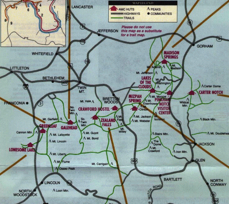
Appalachian Mountain Club owns and maintains a series of eight mountain huts in the White Mountains. Modeled after similar shelters in the Alps, the various huts hold between 36 and 90 people. Hikers may reserve bunks; at most huts dinner and breakfast are included.
The huts' 30-year special use permits were renewed by the U.S. Forest Service in 1999 following a four-year process that included an environmental impact statement. [23]
The Appalachian Mountain Club also operates many campsites and shelters in the White Mountains, the Mahoosucs, and other New England locations. [24] These campsites are often run by caretakers who manage waste, fees, and nearby trails. Nine of the highest use campsites have a $15 per person fee: Kinsman Pond, Liberty Spring, Garfield Ridge, 13 Falls, Guyot, Ethan Pond, Nauman, Imp, and Speck Pond.
The majority of the AMC's activities are conducted by its members who volunteer to lead trips throughout the northeast, from Maine to DC. Activities include hiking, backpacking, paddling, biking, rock climbing, camping, skiing, and snowshoeing, ranging in duration from a day to a week. Additional long-duration domestic and international trips are conducted through the AMC's Adventure Travel program.
The club also operates several trails operations. The Volunteer for Trails program brings teens and adults on day to week long programs teaching trail building and maintenance techniques based out of Camp Dodge in Pinkham Notch. [25] The Roving Conservation Crew is a small crew which works on both backcountry and frontcountry projects around New England. The White Mountain Professional Trail Crew focuses on trail projects within the White Mountains, and the Maine Woods Professional Crew focuses on projects in Maine.
A committee of Appalachian Mountain Club administers the Four Thousand Footer Club. Anyone who has climbed to and from each of the 48 New Hampshire Four-thousand footers is eligible to apply for membership to the club. Members are given a patch and new inductees are invited to attend a yearly celebration dinner. The Four Thousand Footer Club also recognizes individuals who complete the New England Four Thousand Footers (of which there are 67) and the New England Hundred Highest.
Appalachia, the club journal, has been published since 1876. [26] Books relating to subjects such as mountaineering and touring trips are published under the auspices of the society. [8]
The Club's Ponkapoag Camp is listed on the National Register of Historic Places.
The Appalachian Trail, also called the A.T., is a hiking trail in the Eastern United States, extending almost 2,200 miles (3,540 km) between Springer Mountain in Georgia and Mount Katahdin in Maine, and passing through 14 states. The Appalachian Trail Conservancy claims the Appalachian Trail to be the longest hiking-only trail in the world. More than three million people hike segments of the trail each year.
The White Mountains are a mountain range covering about a quarter of the state of New Hampshire and a small portion of western Maine in the United States. They are a subrange of the northern Appalachian Mountains and the most rugged mountains in New England. Several of the higher peaks contain an Alpine tundra. The range is heavily visited due to its proximity to Boston, New York City, and Montreal.
Mount Monadnock, or Grand Monadnock, is a mountain in the towns of Jaffrey and Dublin, New Hampshire. It is the most prominent mountain peak in southern New Hampshire and is the highest point in Cheshire County. It lies 38 miles (61 km) southwest of Concord and 62 miles (100 km) northwest of Boston. At 3,165 feet (965 m), Mount Monadnock is nearly 1,000 feet (305 m) higher than any other mountain peak within 30 miles (48 km) and rises 2,000 feet (610 m) above the surrounding landscape. Monadnock's bare, isolated, and rocky summit provides expansive views. It is known for being featured in the writings of Ralph Waldo Emerson and Henry David Thoreau.
Mount Adams, elevation 5,793 feet (1,766 m) above sea level, is a mountain in New Hampshire, the second highest peak in the Northeast United States after its nearby neighbor, Mount Washington. Located in the northern Presidential Range, Mount Adams was named after John Adams, the second President of the United States. It was given this name on July 31, 1820. To the northeast is Mount Madison and to the southwest is Mount Jefferson. From the summit, Mount Washington can be seen directly to the south.
The Four-thousand footers are a group of forty-eight mountains in New Hampshire at least 4,000 feet (1,200 m) above sea level. To qualify for inclusion a peak must also meet the more technical criterion of topographic prominence important in the mountaineering sport of peak-bagging.
Mount Monroe is a 5,372-foot-high (1,637 m) mountain peak southwest of Mount Washington in the Presidential Range of the White Mountains in New Hampshire, United States. It is named for American President James Monroe and is the fourth highest mountain on the 4000 footers list for New Hampshire. The Appalachian Trail skirts its summit, which is the next highest peak on or near the trail north of Mount Rogers in Virginia. The Lakes of the Clouds, and its AMC hut, lie nestled at the col between Mount Monroe and neighboring Mount Washington.
The High Huts of the White Mountains are eight mountain huts in the White Mountains of New Hampshire, owned and maintained by the Appalachian Mountain Club. They are modeled after similar huts in the Alps and positioned at intervals along the Appalachian Trail, allowing "thru-hikers" who hike the entire Appalachian Trail to benefit from their services. They are generally separated by six to eight miles, about a day's hike.
Bean's Grant is a township in southern Coös County, New Hampshire, United States, north of Crawford Notch State Park. The grant lies entirely within the White Mountain National Forest. The population was zero as of the 2020 census.
The East Peak of Mount Osceola is one of the official New Hampshire 4000-footers, standing at an elevation of 4,156 feet (1,267 m). East Osceola's prominence is between 316 feet (96 m) and 356 feet (109 m), with the key saddle between it and Mount Osceola. It can be approached via the Greeley Ponds trail from the Kancamagus Highway or from the summit of neighboring Osceola. Both routes are not without difficulties; the trail from the ponds is extremely steep and prolonged, and the approach from Osceola contains a chimney, along with a less hazardous bypass by way of the saddle connecting the peaks. The summit is nondescript and surrounded by trees.
The Appalachian National Scenic Trail spans 14 U.S. states over its roughly 2,200 miles (3,500 km): Georgia, North Carolina, Tennessee, Virginia, West Virginia, Maryland, Pennsylvania, New Jersey, New York, Connecticut, Massachusetts, Vermont, New Hampshire, and Maine. The southern end is at Springer Mountain, Georgia, and it follows the ridgeline of the Appalachian Mountains, crossing many of its highest peaks and running almost continuously through wilderness before reaching the northern end at Mount Katahdin, Maine.
Wildcat Mountain is a mountain located in Coos County, northern New Hampshire, United States. The mountain is part of the Carter-Moriah Range of the White Mountains, on the east side of Pinkham Notch. Wildcat Mountain faces Carter Dome across Carter Notch to the northeast, and Mount Washington across Pinkham Notch to the west.
Mount Passaconaway is a 4,043 ft (1,232 m) mountain in the Sandwich Range Wilderness of the White Mountain National Forest in Grafton County, New Hampshire, near Waterville Valley. It is named after Passaconaway, a 16th-century sachem of the Pennacook tribe, whose name was also attached to a small village in Albany, where the northern trailhead is now located.
Mount Zealand, or Zealand Mountain, is a mountain located in the White Mountains, in Grafton County, New Hampshire. Zealand stands on a spur ridge northeast of Mount Guyot, and facing Whitewall Mountain to the east across Zealand Notch.
Mount Willey is a mountain located in Grafton County, New Hampshire. The mountain is named after Samuel Willey, Jr. (1766–1826) and his family, who in 1825 moved into a house in Crawford Notch. The family was killed a year later in August 1826 during a landslide.
The Monadnock-Sunapee Greenway (MSG) is a 50-mile (80 km) hiking trail that traverses the highlands of southern New Hampshire from Mount Monadnock in Jaffrey to Mount Sunapee in Newbury. Located approximately 27 miles (43 km) from the city of Concord, New Hampshire, the trail traverses a rural, heavily glaciated and metamorphic upland studded with lakes, heath barrens, the rocky summits of several monadnocks, and dense woodland of the northern hardwood forest type. The trail is maintained primarily through the efforts of the Monadnock-Sunapee Greenway Trail Club.
Galehead Mountain is a mountain located in Grafton County, New Hampshire. The mountain is part of the Twin Range of the White Mountains. Galehead is flanked to the east by South Twin Mountain, and to the west by Mount Garfield. The summit is reached by the Frost Trail which departs from Galehead Hut. There are several ways to reach the hut from one's car, the Gale River Trail from the northwest being the most direct.
The Pemigewasset Wilderness is a 45,000-acre (182 km2) federally designated Wilderness Area in the heart of New Hampshire's White Mountains. It is a part of the White Mountain National Forest. It is New Hampshire's largest wilderness area.
The Little Lyford Pond camps is a historic logging camp located in the Maine Woods.
Carter Notch is a high mountain pass through the White Mountains of New Hampshire. It is traversed only by hiking trails. The notch is located in the Carter-Moriah Range within the White Mountain National Forest, in Bean's Purchase, Coos County, New Hampshire. It is bordered to the west by Wildcat Mountain, and to the east by Carter Dome. There are two small ponds in the notch, the Carter Lakes, as well as a large boulder field named The Ramparts. The ponds drain south through the talus barrier formed by The Ramparts. The height of land is to the north. To the north, the notch drains via Nineteenmile Brook, which flows into the Peabody River. Drainage to the south is into the Wildcat River, which flows into the Saco River.
The Presidential Traverse is a strenuous and sometimes dangerous trek over the Presidential Range of New Hampshire's White Mountains. Contained almost entirely in the 750,000-acre (3,000 km2) White Mountain National Forest, the Presidential Range is a string of summits in excess of 4,000 feet (1,200 m). To complete the traverse, one must begin at either the northern or southern terminus of the Presidential Range and finish at the opposing end. Beginning the journey at the northern end at Mount Madison, one would pass through the townships of Low and Burbank's Grant, Thompson and Meserve's Purchase, Sargent's Purchase, Chandler's Purchase, and Bean's Grant, all of which are in Coös County.
Media related to Appalachian Mountain Club at Wikimedia Commons