
Grass climbing (German : Grasklettern) is a type of climbing in which, unlike rock climbing, the climber has to scale very steep grass mountainsides, through which the underlying rock protrudes in places.
Grass climbing (German : Grasklettern) is a type of climbing in which, unlike rock climbing, the climber has to scale very steep grass mountainsides, through which the underlying rock protrudes in places.
This type of climbing is used in the Alps, especially in the Bavarian range known as the Allgäu Alps where the numerous grass mountains, which are not high, but very steep, make this mode of ascent necessary or possible (e.g. on the Höfats, Himmelhorn and Schneck). [1]
Other regions notable for grass climbing include: the gorges of the Himalayas, [2] Scotland, [2] Poland's Tatra Mountains, [3] and Lofoten. [4]
The level of protection possible when grass climbing is usually less than that for pure rock climbing. As a result, fatal falls are more common. Experienced grass climbers often use an ice tool.

Bouldering is a form of rock climbing that is performed on small rock formations or artificial rock walls without the use of ropes or harnesses. While bouldering can be done without any equipment, most climbers use climbing shoes to help secure footholds, chalk to keep their hands dry and to provide a firmer grip, and bouldering mats to prevent injuries from falls. Unlike free solo climbing, which is also performed without ropes, bouldering problems are usually less than six metres (20 ft) tall. Traverses, which are a form of boulder problem, require the climber to climb horizontally from one end to another. Artificial climbing walls allow boulderers to climb indoors in areas without natural boulders. In addition, bouldering competitions take place in both indoor and outdoor settings.

Mountaineering, mountain climbing, or alpinism is a set of outdoor activities that involves ascending mountains. Mountaineering-related activities include traditional outdoor climbing, skiing, and traversing via ferratas that have become sports in their own right. Indoor climbing, sport climbing, and bouldering are also considered variants of mountaineering by some, but are part of a wide group of mountain sports.

Many climbing routes have a grade that reflects the technical difficulty—and in some cases the risks and commitment level—of the route. The first ascensionist can suggest a grade, but it will be amended to reflect the consensus view of subsequent ascents. While many countries with a strong tradition of climbing developed grading systems, a small number of grading systems have become internationally dominant for each type of climbing, which has contributed to the standardization of grades worldwide. Over the years, grades have consistently risen in all forms of climbing, helped by improvements in climbing technique and equipment.

Longs Peak is a high and prominent mountain in the northern Front Range of the Rocky Mountains of North America. The 14,259-foot (4346 m) fourteener is located in the Rocky Mountain National Park Wilderness, 9.6 miles (15.5 km) southwest by south of the Town of Estes Park, Colorado, United States. Longs Peak is the northernmost fourteener in the Rocky Mountains of Colorado and the highest point in Boulder County and Rocky Mountain National Park. The mountain was named in honor of explorer Stephen Harriman Long and is featured on the Colorado state quarter.

Scrambling is a mountaineering term for ascending steep terrain using one's hands to assist in holds and balance. "A scramble" is a related term, denoting terrain that could be ascended in this way. It can be described as being between hiking and rock climbing.

Glossary of climbing terms relates to rock climbing, mountaineering, and to ice climbing.

In mountaineering and climbing, a first ascent, is the first successful documented climb to the top of a mountain or the top of a particular climbing route. Early 20th-century mountaineers and climbers focused on reaching the tops of iconic mountains and climbing routes by whatever means possible, often using considerable amounts of aid climbing, and/or with large expedition style support teams that laid "siege" to the climb.

Ice climbing is a climbing discipline that involves ascending routes consisting of frozen water. To ascend, the ice climber uses specialist equipment, particularly double ice axes and rigid crampons. To protect the route, the ice climber uses steel ice screws that require skill to employ safely and rely on the ice holding firm in any fall. Ice climbing routes can vary significantly by type, and include seasonally frozen waterfalls, high permanently frozen alpine couloirs, and large hanging icicles.
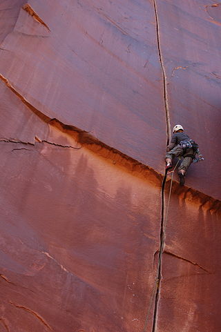
Rock climbing is a climbing sports discipline that involves ascending routes consisting of natural rock in an outdoor environment, or on artificial resin climbing walls in a mostly indoor environment. Routes are chronicled in guidebooks, and on online databases, with the details of how to climb the route, and who made the first ascent and the coveted first free ascent. Climbers will try to ascend a route onsight, however, a climber can spend years projecting a route before they make a redpoint ascent.

A via ferrata is a protected climbing route found in the Alps and certain other Alpine locations. The protection includes steel fixtures such as cables and railings to arrest the effect of any fall, which the climber can either hold onto or clip into using climbing protection. Some via ferrata can also include steel fixtures that provide aid in overcoming the obstacles encountered, including steel ladders and steel steps.

The Barre des Écrins is a mountain in the French Alps with a peak elevation of 4,102 metres (13,458 ft). It is the highest peak of the Massif des Écrins and the Dauphiné Alps and the most southerly alpine peak in Europe that is higher than 4,000 metres. It is the only 4,000-metre mountain in France that lies outside the Mont Blanc Massif. Before the annexation of Savoy in 1860 it was the highest mountain in France.

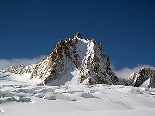
A grass mountain in topography is a mountain covered with low vegetation, typically in the Alps and often steep-sided. The nature of such cover, which often grows particularly well on sedimentary rock, will reflect local conditions.

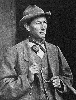
Henry Barber is an American rock climber and ice climber who rose to prominence in the 1970s. Known by the nickname "Hot Henry", Barber was an advocate of clean climbing, a prolific first ascenscionist and free soloist. He was one of the first American rock climbers to travel widely to climb in different countries, and was one of the first "professional" American rock climbers, supporting himself as a sales representative for outdoor equipment companies including Chouinard Equipment and Patagonia, and by giving lectures and slide shows. He was an integral member of the "Front Four" quartet of the 1970s: "Hot Henry", John Stannard, Steve Wunsch, and John Bragg.
Rudolf Fehrmann was a German climber. He was a pioneer rock climber at the Elbe Sandstone Mountains near Dresden.

Mixed climbing is a climbing discipline used on routes that do not have enough ice to be pure ice climbs, but are also not dry enough to be pure rock climbs. To ascend the route, the mixed climber uses ice climbing equipment, but to protect the route, they use both rock-climbing equipment and ice climbing equipment. Mixed climbing varies from routes with sections of thick layers of ice and sections of bare rock, to routes that are mostly bare rock but which are "iced-up" in a thin layer of ice and/or snow.
At 2,744 metres (9,003 ft), the Hochwanner is the second highest mountain in Germany after the Zugspitze. In addition the Hochwanner is the highest peak on the main ridge of the Wetterstein (Wettersteinhauptkamm) running from Gatterl to the Upper Wettersteinspitze above Mittenwald in an east–west direction. From the Hochwanner massif there is an all-round view of the Rein valley (Reintal), the Leutasch valley in Austria, the Gais valley, the Zugspitze, the Mieming Chain, the Jubiläumsgrat, the Karwendel mountains and far into the central Alps.
The Fritzerkogel is a mountain in the Tennengebirge in the northern Limestone Alps, Austria. With its elevation of 2,360 metres (7,740 ft), is one of the higher peaks in the mountain range. Seen from the north it stands out as a relatively isolated, broad summit block, whose mighty rock faces and steep, rugged, rocky flanks (Schrofen) fall away on all sides. Its 1,200-metre-high (3,900 ft) south cliff face is impressive and makes it a striking two-thousander.

Alpine climbing is a type of mountaineering that uses any of a broad range of advanced climbing skills, including rock climbing, ice climbing, and/or mixed climbing, to summit typically large routes in an alpine environment. While alpine climbing began in the European Alps, it is used to refer to climbing in any remote mountainous area, including in the Himalayas and Patagonia. The derived term alpine style refers to the fashion of alpine climbing to be in small lightly equipped teams who carry their equipment, and do all of the climbing.
Émile Rey was an alpine mountain guide from Aosta Valley in Italy. Dubbed "the Prince of Guides" in Courmayeur, he was one of the most renowned guides at the end of the 19th century, making many first ascents on some of the highest and most difficult mountains in the Mont Blanc massif of the Alps. He has been described as "one of the greatest guides of his generation."
The Tour Ronde is a mountain in the Mont Blanc massif of the Alps, situated on the border between France and Italy. It is a prominent mountain, some 3.5 km north-east of Mont Blanc, but is effectively part of a continuation of the south eastern spur of Mont Maudit which forms a frontier ridge between the two countries. It is easily accessible to mountaineers and provides not only a very good viewpoint from its summit of the Brenva face and the major peaks on the southern side of Mont Blanc, but it also offers a popular introduction to alpine climbing of all grades, including a north face ascent.