High Huts of the White Mountains

Last updated
Greenleaf Hut on the shoulder of Mount Lafayette Greenleaf Mountain Hut.jpg
Greenleaf Hut on the shoulder of Mount Lafayette
Map all coordinates using: OpenStreetMap  
Download coordinates as: KML

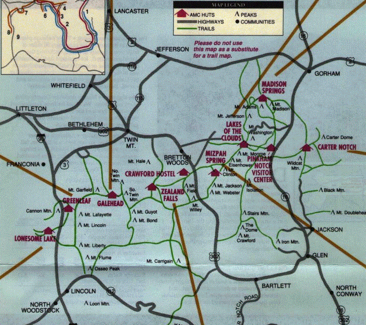
The High Huts of the White Mountains are eight mountain huts in the White Mountains of New Hampshire, owned and maintained by the Appalachian Mountain Club. They are modeled after similar huts in the Alps and positioned at intervals along the Appalachian Trail, allowing "thru-hikers" who hike the entire Appalachian Trail to benefit from their services. They are generally separated by six to eight miles, about a day's hike.

Contents

Hikers can reserve overnight bunks at the huts, which hold from 36 to 96 people each. They offer full service from June through mid-September, serving dinner and breakfast. Three huts stay open the rest of the year as self service, allowing guests to cook their own food in the kitchen.

The huts are staffed by a team of five to nine caretakers—often called "the croo" [1] —during full-service season. Each crew member works eleven days on, three days off. During the eleven working days, they must make four trips back down the mountain to get food and other supplies, carrying heavy loads. At the beginning of each season, fuel and supplies are flown into the huts by helicopter. The huts were built and are maintained by the Appalachian Mountain Club's construction crew.

The huts have handled thousands of hikers entering the back woods and environmentally sensitive areas above tree line. Four years and an environmental impact statement were required to get the huts' permits renewed by the U.S. Forest Service in 1999. [2]

The winter huts closed in March 2020 and the other huts did not open for the summer 2020 season due to the COVID-19 pandemic. This was the first time that all huts have been closed at once. [3] The huts re-opened on June 26, 2020, for daytime visits only.

Hut history

The following High Huts are presented in the order they would be reached when hiking the Appalachian Trail from south to north.

Lonesome Lake

Lonesome Lake Hut ( 44°08′19″N71°42′12″W / 44.1385°N 71.7033°W / 44.1385; -71.7033 (Lonesome Lake Hut) ) is the second lowest hut in the system. It started out in 1876 as a fishing camp on Lonesome Lake, with cabins built by author W.C. Prime. The hut officially became part of the AMC system in 1929, when the State of New Hampshire bought the land and invited the club to run it as a shelter. [4] [5]

Greenleaf

Greenleaf Hut ( 44°09′37″N71°39′37″W / 44.1603°N 71.6604°W / 44.1603; -71.6604 (Greenleaf Hut) ) lies on a prominent shoulder of Mount Lafayette, with views of Franconia Ridge. Its construction was the first to leave behind the stone and masonry construction technique utilized by earlier huts, and to use a team of mules to carry materials. It was completed in 1930 and pioneered running water and indoor toilets, reflecting an evolution of AMC huts from simple shelters towards becoming more like mountainside hostels. Much of Greenleaf's construction funding came from Colonel Charles Greenleaf, for whom it is named. It features a central dining room and kitchen flanked by two bunkrooms, a design which became the model for Galehead and Zealand Falls huts, both constructed within the next year. It is 4,200 feet (1,300 m) above sea level. [6] [7]

Galehead

Galehead Hut ( 44°11′16″N71°34′08″W / 44.1879°N 71.5688°W / 44.1879; -71.5688 (Galehead Hut) ) lies nearly 3,800 feet (1,200 m) above sea level on rugged Garfield Ridge. Construction on the original structure there began in 1931, using wood from the surrounding trees. It was completed in 1932, along with Zealand Falls Hut, its closest northern neighbor. A small space under the front porch was used to store perishable foods. In 1938, Galehead gained a temporary 360 degree view when the Great New England Hurricane blew over all the surrounding trees. It was replaced in June 2000 with a new Americans with Disabilities Act-compliant hut, complete with a wheelchair ramp even though it is 5 miles (8 km) of rough trail from the nearest trailhead. [8] Given its altitude and remoteness, the vast majority of the new structure's materials had to be carried in; thus mainly lightweight materials were utilized. New features include composting toilets (already in use at Mizpah Spring Hut, Carter Notch Hut, and Lonesome Lake Hut), both solar panels and a wind vane for producing power, and a foundation fastened to the granite bedrock with grouted rebar, giving the hut the ability to withstand winds up to 125 miles per hour (200 km/h). The hut is 0.9 miles (1.4 km) from the summit of South Twin Mountain and 0.5 miles (800 m) from the summit of Galehead Mountain. [9] [10] [11]

Zealand Falls

Zealand Falls Hut ( 44°11′46″N71°29′40″W / 44.1960°N 71.4944°W / 44.1960; -71.4944 (Zealand Falls Hut) ) was completed in 1932 along with Galehead and has been open in the winter season since 1973. It, like Lonesome Lake hut, is notable as a "family" hut due to its low altitude and relatively easy approach climb. It also has the lowest capacity of all the huts, sleeping little more than a third of the largest capacity hut. [12] [13]

Mizpah Spring

Mizpah Spring Hut Mizpah Spring Hut.jpg
Mizpah Spring Hut

Mizpah Spring Hut ( 44°13′09″N71°22′10″W / 44.2193°N 71.3695°W / 44.2193; -71.3695 (Mizpah Spring Hut) ) was originally built in 1964, and although there are newer buildings in the system, this makes Mizpah the newest hut site in the system. The building is designed to withstand 200 miles per hour (320 km/h) winds and was built with materials brought in by helicopter. [14] [15]

Lakes of the Clouds

Lakes of the Clouds Hut at sunset Lakes of the Clouds at Sunset.jpg
Lakes of the Clouds Hut at sunset

Lakes of the Clouds Hut ( 44°15′32″N71°19′08″W / 44.2588°N 71.3190°W / 44.2588; -71.3190 (Lakes of the Clouds Hut) ) is the highest and largest hut in the system. It was built as a shelter in 1901 in response to the deaths of two hikers the previous year who were caught in a storm on their way to an AMC meeting atop Mount Washington. It was rebuilt as a hut in 1915, and was renovated in 1922, 1927, 1947, 1969, and 2005. Although it is the highest of the huts, at an elevation of 5,030 feet (1,533 m), it is the most easily accessible due to its proximity to the summit of Mount Washington, which can be reached by car and by the Mount Washington Cog Railway. It is located adjacent to its namesake Lakes of the Clouds, two small alpine tarns, and just below the 5,372 ft (1,637 m) summit of Mount Monroe. The hut provides bunks for 90 hikers. It is sometimes called "Lakes of the Crowds" due to its size and popularity. [16] [17]

Madison Spring

Madison Spring Hut Madison spring hut.jpg
Madison Spring Hut

Madison Spring Hut ( 44°19′40″N71°17′00″W / 44.3277°N 71.2832°W / 44.3277; -71.2832 (Madison Spring Hut) ), originally built in 1888, is the oldest hut site in the United States. The first overnight guests stayed in the winter of 1889, and in 1906 a fee of 50 cents per night was instituted to utilize the shelter. The original hut was expanded in that same year, as well as 1911, 1922, and 1929. However, in 1940, a fire—caused by the ignition of gasoline for the gasoline-electric power generator—destroyed much of the hut. The following year it was rebuilt and re-opened. The hut was extensively rehabilitated in the fall of 2010 and early 2011. [18]

At 4,810 feet (1,466 m) above sea level, it is the second highest hut in the chain, and it sleeps the third highest number of guests. The hut is accessed most directly from the Valley Way trail (from the Appalachia parking lot). It is generally considered the most difficult of the full-service huts to access, based on distance and elevation required to reach it. [19] [20]

Carter Notch

Carter Notch Hut ( 44°15′33″N71°11′44″W / 44.2591°N 71.1955°W / 44.2591; -71.1955 (Carter Notch Hut) ) is the easternmost hut in the system [21] and is open year-round. Between 1996 and 2006, it operated on a self-service basis; since then it has resumed operating as a full-service hut during the summer season, remaining self-service the rest of the year. [22] [23] The site's use as a shelter began in 1904 as a simple log cabin; the building was rebuilt as a hut in 1914, making Carter Notch the oldest building in the hut chain, supposedly by Milton McGregor, aka "Red Mac". [24] There are two bunkhouses located a short distance from the main hut structure; thus from the cliffs above, the hut is viewed as a small compound. There are two small ponds located nearby, as well as a tremendous boulder field. Carter Notch helped establish the hut as a viable pursuit for the AMC, and after its initial success, the group began to lay plans for a hut system. [10] [25]

Table

HutLocationElevationCapacitySleeping arrangement
Carter Notch Hut
3,288 feet
40
Two bunkhouses with coed rooms for four to six people
Galehead Hut
3,800 feet
38
Four coed bunkrooms
Greenleaf Hut
4,200 feet
48
Two coed bunkrooms
Lakes of the Clouds Hut
Southern shoulder of Mount Washington
5,030 feet
96
Coed bunkrooms
Lonesome Lake Hut
2,760 feet
48
Two bunkhouses with coed rooms for four to six people
Madison Spring Hut
4,800 feet
52
Two coed bunkrooms
Mizpah Spring Hut
Mount Pierce (often referred to as Mount Clinton)
3,800 feet
60
Coed bunkrooms for four to eight people
Zealand Falls Hut
2,637 feet
36
Two coed bunkrooms

Related Research Articles

<span class="mw-page-title-main">Appalachian Trail</span> Hiking trail going through fourteen US states

The Appalachian Trail, is a hiking trail in the Eastern United States, extending almost 2,200 miles (3,540 km) between Springer Mountain in Georgia and Mount Katahdin in Maine, and passing through 14 states. The Appalachian Trail Conservancy claims the Appalachian Trail to be the longest hiking-only trail in the world. More than three million people hike segments of the trail each year.

<span class="mw-page-title-main">Appalachian Mountain Club</span> Hiking club

Appalachian Mountain Club (AMC) is the oldest outdoor group in the United States. Created in 1876 to explore and preserve the White Mountains in New Hampshire, it has expanded throughout the northeastern U.S., with 12 chapters stretching from Maine to Washington, D.C. The AMC's 275,000 members, advocates, and supporters mix outdoor recreation, particularly hiking and backpacking, with environmental activism. Additional activities include cross-country skiing, whitewater and flatwater canoeing and kayaking, sea kayaking, sailing, rock climbing and bicycle riding. The Club has about 2,700 volunteers, who lead roughly 7,000 trips and activities per year. The organization publishes a number of books, guides, and trail maps.

The Cohos Trail is a hiking trail running 162 miles (260 km) through northern New Hampshire in the United States, connecting the northern and southern ends of Coos County. It begins at Notchland, near Crawford Notch State Park, and follows a series of trails to the hamlet of Fabyans, then over Cherry Mountain to the town of Jefferson, over Mount Waumbek, along the Kilkenny Ridge Trail to Stark, through Nash Stream Forest to Dixville Notch, and north to the Connecticut Lakes and finally the Canada–US border at the southern edge of Quebec. There it connects with the Sentier Frontalier's trail to Mount Megantic and Mount Gosford in Canada.

<span class="mw-page-title-main">Franconia Notch State Park</span> State park in New Hampshire, United States

Franconia Notch State Park is a public recreation area and nature preserve that straddles eight miles (13 km) of Interstate 93 as it passes through Franconia Notch, a mountain pass between the Kinsman Range and Franconia Range in the White Mountains of northern New Hampshire, United States. The northern part of the park, including Cannon Mountain and Echo and Profile lakes, is in the town of Franconia, and the southern part, including Lonesome Lake and the Flume, is in Lincoln. Attractions in the state park include the Flume Gorge and visitor center, the Old Man of the Mountain historical site, fishing in Echo Lake and Profile Lake, and miles of hiking, biking and ski trails.

<span class="mw-page-title-main">Mountain hut</span> Building located in the mountains, generally accessible only by foot

A mountain hut is a building located high in the mountains, generally accessible only by foot, intended to provide food and shelter to mountaineers, climbers and hikers. Mountain huts are usually operated by an Alpine Club or some organization dedicated to hiking or mountain recreation. They are known by many names, including alpine hut, mountain shelter, mountain refuge, mountain lodge, and mountain hostel. It may also be called a refuge hut, although these occur in lowland areas too.

<span class="mw-page-title-main">Mount Lafayette</span> Mountain in New Hampshire

Mount Lafayette is a 5,249-foot (1,600 m) mountain at the northern end of the Franconia Range in the White Mountains of New Hampshire, United States. It lies in the town of Franconia in Grafton County, and appears on the New England Fifty Finest list of the most topographically prominent peaks in New England. The mountain's upper reaches are located in the alpine zone, an area where only dwarf vegetation exists due to the harsh climate.

<span class="mw-page-title-main">Cannon Mountain (New Hampshire)</span>

Cannon Mountain is a 4,080-foot (1,240 m) peak in the White Mountains of New Hampshire. It is known for both its technical rock and ice climbing on its cliff face and skiing at Cannon Mountain Ski Area. It was also home to the Old Man of the Mountain, until that formation collapsed on May 3, 2003.

<span class="mw-page-title-main">South Twin Mountain (New Hampshire)</span>

South Twin Mountain is a mountain located in Grafton County, New Hampshire. The mountain is part of the Twin Range of the White Mountains. South Twin forms the high point of a north-south ridge, with North Twin Mountain lying approximately one mile to the north and Mount Guyot two miles (3 km) to the southeast. Galehead Mountain, a lower spur of South Twin, is to the west.

<span class="mw-page-title-main">Mount Moosilauke</span>

Mount Moosilauke is a 4,802-foot-high (1,464 m) mountain at the southwestern end of the White Mountains in the town of Benton, New Hampshire, United States. It is the tenth highest and most southwesterly of the 4,000 foot summits in the White Mountains.

<span class="mw-page-title-main">Mount Monroe</span>

Mount Monroe is a 5,372-foot-high (1,637 m) mountain peak southwest of Mount Washington in the Presidential Range of the White Mountains in New Hampshire, United States. It is named for American President James Monroe and is the fourth highest mountain on the 4000 footers list for New Hampshire. The Appalachian Trail skirts its summit, which is the next highest peak on or near the trail north of Mount Rogers in Virginia. The Lakes of the Clouds, and its AMC hut, lie nestled at the col between Mount Monroe and neighboring Mount Washington.

<span class="mw-page-title-main">Bean's Grant, New Hampshire</span> Township in Coos County, New Hampshire, United States

Bean's Grant is a township in southern Coös County, New Hampshire, United States, north of Crawford Notch State Park. The grant lies entirely within the White Mountain National Forest. The population was zero as of the 2020 census.

<span class="mw-page-title-main">Pinkham Notch</span> Mountain pass in New Hampshire

Pinkham Notch is a mountain pass in the White Mountains of north-central New Hampshire, United States. The notch is a result of extensive erosion by the Laurentide Ice Sheet during the Wisconsinian ice age. Pinkham Notch was eroded into a glacial U-shaped valley whose walls are formed by the Presidential, Wildcat, and Carter-Moriah ranges. Due to the volatility of the area's climate and rugged character of the terrain, a number of rare or endemic ecosystems have developed throughout the notch.

The Appalachian National Scenic Trail spans fourteen U.S. states during its roughly 2,200 miles (3,500 km)-long journey: Georgia, North Carolina, Tennessee, Virginia, West Virginia, Maryland, Pennsylvania, New Jersey, New York, Connecticut, Massachusetts, Vermont, New Hampshire, and Maine. The southern end is at Springer Mountain, Georgia, and it follows the ridgeline of the Appalachian Mountains, crossing many of its highest peaks and running almost continuously through wilderness before reaching the northern end at Mount Katahdin, Maine.

<span class="mw-page-title-main">Wildcat Mountain (New Hampshire)</span>

Wildcat Mountain is a mountain located in Coos County, northern New Hampshire, United States. The mountain is part of the Carter-Moriah Range of the White Mountains, on the east side of Pinkham Notch. Wildcat Mountain faces Carter Dome across Carter Notch to the northeast, and Mount Washington across Pinkham Notch to the west.

<span class="mw-page-title-main">Mount Zealand</span>

Mount Zealand, or Zealand Mountain, is a mountain located in the White Mountains, in Grafton County, New Hampshire. Zealand stands on a spur ridge northeast of Mount Guyot, and facing Whitewall Mountain to the east across Zealand Notch.

<span class="mw-page-title-main">Lonesome Lake (New Hampshire)</span> Body of water

Lonesome Lake is a 12.2-acre (49,000 m2) water body located in Franconia Notch in the White Mountains of New Hampshire, south of Cannon Mountain. The lake is reachable by hiking trails from the Franconia Notch Parkway, including the Lafayette Place Campground, and takes approximately 2–3 hours. It features an Appalachian Mountain Club hut, which first opened in 1930, on its southwest shore.

<span class="mw-page-title-main">Carter Notch</span>

Carter Notch is a high mountain pass through the White Mountains of New Hampshire. It is traversed only by hiking trails. The notch is located in the Carter-Moriah Range within the White Mountain National Forest, in Bean's Purchase, Coos County, New Hampshire. It is bordered to the west by Wildcat Mountain, and to the east by Carter Dome. There are two small ponds in the notch, the Carter Lakes, as well as a large boulder field named The Ramparts. The ponds drain south through the talus barrier formed by The Ramparts. The height of land is to the north. To the north, the notch drains via Nineteenmile Brook, which flows into the Peabody River. Drainage to the south is into the Wildcat River, which flows into the Saco River.

<span class="mw-page-title-main">Mount Willard (New Hampshire)</span>

Mount Willard, elevation 2,865 feet (873 m), is a mountain located in Carroll County, New Hampshire, United States, in the center of Crawford Notch. Its summit provides excellent views, and it is accessible by the Mount Willard Trail.

<span class="mw-page-title-main">Kinsman Range</span>

The Kinsman Range, also known as the Cannon–Kinsman Range, is a north–south range in the White Mountains of New Hampshire in the United States. Its highest point is 4,358-foot-high (1,328 m) Kinsman Mountain, followed by the 4,293-foot (1,309 m) North Peak of Kinsman, and 4,080-foot (1,240 m) Cannon Mountain, one of the richest in rock climbing routes in the Whites. All are official "Four-thousand footers". 3,478-foot (1,060 m) Mount Wolf is on the crest of the range south of Kinsman Mountain. Rounding out the range is 2,470-foot (750 m) Bald Peak on the west side of Kinsman Mountain.

<span class="mw-page-title-main">Crawford Path</span> Hiking trail in the White Mountains of New Hampshire

The Crawford Path is an 8.5-mile-long (13.7 km) hiking trail in the White Mountains of New Hampshire that is considered to be the United States' oldest continuously maintained hiking trail. It travels from Crawford Notch to the summit of Mount Washington (Agiocochook). The first iteration of the Crawford Path was cut in 1819 by Ethan Allen Crawford and his father, Abel Crawford. The trail ascends a cumulative 4,900 feet (1,500 m), first through densely wooded forest for about 3.1 miles (5.0 km), then following the exposed southern ridge of the Presidential Range mostly above the treeline.

References

  1. "White Mountain Huts of New Hampshire - AMC". www.outdoors.org.
  2. Forest magazine (Dec. 2000): "A Rough Stretch of Trail." Archived 2013-12-24 at the Wayback Machine
  3. WCAS: White Mountain huts closed
  4. "Historic Profile: Lonesome Lake Hut". AMC. Archived from the original on 2006-09-29. Retrieved 2009-04-22.
  5. "Lonesome Lake Hut". AMC. Retrieved 2009-04-22.
  6. "Historic Profile: Greenleaf Hut". AMC. Archived from the original on 2008-12-27. Retrieved 2009-04-22.
  7. "Greenleaf Hut". AMC. Retrieved 2009-04-22.
  8. Carey Goldberg (August 17, 2000). "For These Trailblazers, Wheelchairs Matter". The New York Times . Retrieved 2009-04-22.
  9. "Historic Profile: Galehead Hut". AMC. Archived from the original on 2008-12-27. Retrieved 2009-04-22.
  10. 1 2 "Galehead Hut". AMC. Retrieved 2009-04-22.
  11. "Galehead Hut Blends the Best of the Old and New". AMC. Archived from the original on 2008-12-27. Retrieved 2009-04-22.
  12. "Historic Profile: Zealand Falls Hut". AMC. Archived from the original on 2010-01-16. Retrieved 2009-04-22.
  13. "Zealand Falls Hut". AMC. Retrieved 2009-04-22.
  14. "Historic Profile: Mizpah Spring Hut". AMC. Archived from the original on 2009-02-15. Retrieved 2009-04-22.
  15. "Mizpah Spring Hut". AMC. Retrieved 2009-04-22.
  16. "Historic Profile: Lakes of the Clouds Hut". AMC. Archived from the original on 2009-08-06. Retrieved 2009-04-22.
  17. "Lakes of the Clouds Hut". AMC. Retrieved 2009-04-22.
  18. "Rebuilding Madison Spring Hut". AMC Outdoors. Archived from the original on 2010-12-26. Retrieved 2011-03-19.
  19. "Historic Profile: Madison Spring Hut". AMC. Archived from the original on 2009-02-15. Retrieved 2009-04-22.
  20. "Madison Spring Hut". AMC. Retrieved 2009-04-22.
  21. "Carter Notch Hut". AMC. Retrieved 2009-04-22.
  22. "2009 White Mountain Hut Rates". AMC. Retrieved 2009-04-22.
  23. "AMC Carter Notch Hut Returns to Full Service in Summer 2007". AMC. October 11, 2006. Retrieved 2009-04-22.
  24. Perry, Tristan. Ghostly Legends of the Appalachian Trail. Wever, Iowa: Quixote Press, 2008. Pages 77-91.
  25. "Historic Profile: Carter Notch Hut". AMC. Archived from the original on 2009-02-14. Retrieved 2009-04-22.