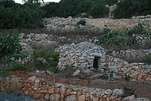
A girna (plural giren) is a type of traditional corbelled hut found in rural areas in parts of Malta. They bear similarities with a number of dry stone vernacular building types found in other Mediterranean countries, and they are primarily used for storage or as temporary shelters. It is possible that in the past they were also used for human habitation.
It is not known when the first giren were constructed in Malta. [2] Their typology bears some similarities with the Megalithic Temples of Malta, although there is no conclusive proof that the building traditions are directly linked, [3] and it has been suggested that the resemblance is superficial. [4] The huts also share characteristics with other vernacular constructions in the Mediterranean region, such as the nuraghe of Sardinia, the trulli of Apulia, the bunje of the former Yugoslavia, [3] the borie of France [5] and other types of huts found in Sicily and Libya. [3]
In his 1536 publication Insulae Melitae Descriptio, Jean Quintin mentioned that the Maltese countryside contained many vernacular structures which he called "African huts", and this might have referred to the girna. [4] Larger giren were probably used for human habitation, [3] and it is likely that many were abandoned as isolated rural communities gave way to larger villages and towns in the 17th and 18th centuries. [4] Smaller giren were mostly used to store tools or hay, as temporary shelters for farmers or herders, or to house goats, sheep or other livestock. [2] [6] [7] The frequency of giren near certain quarries, such as in Qala on Gozo, suggests that some were also used as shelters for workmen. [5]
Due to the primitive nature of their construction, giren were not particularly influenced by changes which occurred in other aspects of Maltese architecture over the centuries. [3] Assigning a date of construction to a particular girna is difficult unless it is documented in other evidence, but it is believed that many of the existing structures are relatively recent. [4] The first study of the girna was made by Paul Cassar in 1961, [8] and several other studies have been published since then, most notably a book in Maltese by historian Mikiel Fsadni in 1990 [9] which was also translated to English in 1992. [4]
Many giren have been lost through neglect, [4] [7] but many others still exist and some remain in use, mainly for storage. [10] A few giren are still being built as of the early 21st century; for example, one was constructed at the Ta' Blankas olive grove in Xewkija in 2014 as part of a refurbishment project. [11]
Most giren are found in rural areas in the northern part of the main island of Malta. They are especially frequent in the limits of Mellieħa, including the land around Manikata, l-Aħrax tal-Mellieħa, the area around Selmun Palace and the area between Saint Agatha's Tower and Paradise Bay. [7] Over 30 giren can be found in the Majjistral Park. [10] Other areas in the northwestern part of Malta which contain some giren include Żebbiegħ, Bidnija, Dingli, Baħrija and Mtaħleb. [7]
The areas where giren are located usually contain rocky outcrops of hard coralline limestone, which was the main material used in the huts' construction. These areas tended to lack more workable materials such as globigerina limestone. This might explain why giren are less common in the southern part of Malta and on the island of Gozo, where globigerina limestone is abundant and where it was often used to construct ashlar masonry buildings. Most giren in Gozo are clustered in the parts of the island which consist of Upper Coralline Limestone, such as Xagħra, Nadur and Qala. [5]
Giren are huts constructed out of undressed dry stone, and they were usually built out of loose pieces of coralline limestone, [7] which were either obtained through quarrying [8] or through clearing loose stones from a piece of land in order to allow for it to be cultivated. [6] The walls are usually around 90 cm (35 in) thick, [7] and they consist of two skins of stone with a rubble infill known as mazkan in between. [5] The roof of the girna is constructed using corbelling, with each row of stones jutting out slightly from the row below it, gradually reducing the size of the opening until flat stone slabs can be used to span it. This results in a dome-shaped concave ceiling, [7] bearing similarities to ancient beehive tombs. [3] Gravel and torba were usually used to cover the roof, [2] while sometimes a pebble-like material called ċagħqija was used for this purpose. [7]
Most giren have a circular plan, but there are some which are square, rectangular or oval-shaped. [3] They usually have a single door facing east [7] or south, [5] and this opening is spanned by lintels, while some also have windows. Some giren were additionally buttressed by rubble walls, and a few allow access to the roof through an external staircase or ramp. There are also examples of giren with two floors, consisting of one hut built on top of another. Mangers were sometimes found inside giren used to raise livestock. [7]
The huts are prone to collapse if they are left without proper maintenance. [7]
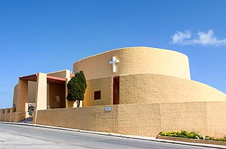
In the 1960s, the Maltese architect Richard England drew inspiration from the girna when designing the curved walls of the Manikata parish church, which is regarded as one of the most iconic 20th century churches in Malta. [12] [13] England also designed a residential building called Villa Girna which used the vernacular huts as a source of inspiration, but it was never actually constructed. [14]
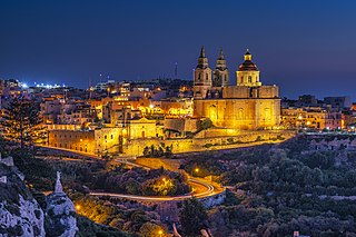
Mellieħa is a large village in the Northern Region of Malta. It has a population of 10,087 as of March 2014. Mellieħa is also a tourist resort, popular for its sandy beaches, natural environment, and Popeye Village nearby.
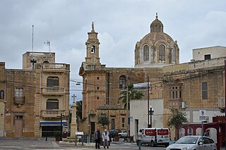
Nadur is an administrative unit of Malta, located in the eastern part of the island of Gozo. Nadur is built on a plateau and is one of the largest localities in Gozo. Known as the 'second city', it spreads along a high ridge to the east of Victoria. It had a population of 4,509 as of March 2014.
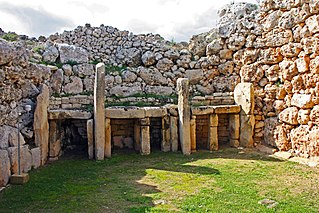
The Megalithic Temples of Malta are several prehistoric temples, some of which are UNESCO World Heritage Sites, built during three distinct periods approximately between 3600 BC and 2500 BC on the island country of Malta. They had been claimed as the oldest free-standing structures on Earth until the discovery of Göbekli Tepe in Turkey. Archaeologists believe that these megalithic complexes are the result of local innovations in a process of cultural evolution. This led to the building of several temples of the Ġgantija phase, culminating in the large Tarxien temple complex, which remained in use until 2500 BC. After this date, the temple-building culture disappeared.
Manikata is a small settlement in the limits of Mellieħa in the northwestern part of Malta. It oversees the farming areas in the valley between il-Ballut and il-Manikata. The village's population of 539 is spread among 40 families.
Malta is for non-local government purposes divided into districts as opposed to the local government localities. The three main types of such districts – statistical, electoral at national level, and policing – have no mainstream administrative effect as the local councils form the first-tier – moreover only administrative tier – divisions of the country.
This page list topics related to Malta.
The coastline of Malta consists of bays, sandy beaches, creeks, harbours, small villages, cities, cliffs, valleys, and other interesting sites. Here, there is a list of these different natural features that are found around the coast of Malta.
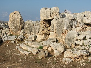
The Ta' Ħaġrat temples in Mġarr, Malta are recognized as a UNESCO World Heritage Site, along with several other Megalithic temples. They are amongst the world's oldest religious sites. The larger Ta' Ħaġrat temple dates from the Ġgantija phase ; the smaller is dated to the Saflieni phase.
The Gozitan First Division, known for sponsorship reasons as the BOV GFL First Division, is the top division of the Gozo Football League, the league competition for men's football clubs in Gozo.
Post codes in Malta are seven-character strings that form part of a postal address in Malta. Post codes were first introduced in 1991 by the mail operator MaltaPost. Like those in the United Kingdom and Canada, they are alphanumeric.
In Malta most of the main roads are in the outskirts of the localities to connect one urban area with another urban area. The most important roads are those that connect the south of the island with the northern part, like Tal-Barrani Road, Aldo Moro Street in Marsa and Birkirkara Bypass.
Gozo Region is one of five regions of Malta. The region includes the islands of Gozo, Comino and several little islets such as Cominotto. The region does not border with any other regions, but it is close to the Northern Region.
A Gozo Farmhouse is a type of dwelling in Gozo, Malta. Because of the many foreign occupations that Maltese islands have been through, the trading roads that were opened across the Mediterranean Sea and its numerous original influences, Malta and Gozo earned a very rich architectural heritage.
The Devil's Farmhouse, also known in Maltese as Ir-Razzett tax-Xitan, and officially as Ir-Razzett Tax-Xjaten, is an 18th-century farmhouse in Mellieħa, Malta. The farmhouse features two unconnected buildings. The original scope for the buildings were to function as stables and a horse-riding school (Cavalerizza).
The Basilica of St Peter and St Paul is a Roman Catholic minor basilica and parish church located in Nadur, Gozo in Malta.
The Parish Church of Saint Joseph is an iconic Roman Catholic parish church in Manikata, Malta, dedicated to Saint Joseph. It was designed by Richard England in 1962, and it was built between 1964 and 1974. The church marks a break from traditional church building designs, and it is an example of Critical regionalism. Its form is inspired by the girna, a traditional corbelled stone hut.
The 2019–20 Maltese FA Trophy was the 82nd edition of the football cup competition.
Mikiel Fsadni was a Maltese Dominican friar and historian. He is best known for the discovery of Il-Kantilena, the oldest known text in the Maltese language, together with Godfrey Wettinger in 1966.
Media related to Giren at Wikimedia Commons