Lake Chaubunagungamaug

Last updated

Lake Chaubunagungamaug
Webster Lake
Lake Name.jpg
Name of the lake on a bridge
Relief map of USA Massachusetts.png
Red pog.svg
Lake Chaubunagungamaug
Usa edcp relief location map.png
Red pog.svg
Lake Chaubunagungamaug
Location Webster, Massachusetts
Coordinates 42°02′30″N71°50′30″W / 42.04167°N 71.84167°W / 42.04167; -71.84167
Type lake
Basin  countries United States
Max. length3.25 mi (5.23 km)
Max. width1.125 mi (1.811 km)
Surface area1,442 acres (584 ha)
Average depth13 ft (4.0 m)
Max. depth49 ft (15 m)
Shore length117 mi (27 km)
Surface elevation477 ft (145 m)
Islands 8
1 Shore length is not a well-defined measure.

Lake Chaubunagungamaug, also known as Webster Lake, is a lake in the town of Webster, Massachusetts. It is located near the Connecticut border and has a surface area of 1,442 acres. Since 1921, the lake has also been known by a much longer name having 45 letters comprising fourteen syllables: Lake Char­gogg­a­gogg­man­chaugg­a­gogg­chau­bun­a­gung­a­maugg. The lake has become famous beyond Central Massachusetts for having the longest name of any geographic feature in all of the United States.

Contents

Name

The lake's name comes from Loup, an Algonquian language,[ citation needed ] and is often said to mean, "Fishing Place at the Boundaries—Neutral Meeting Grounds". [1] A more fitting translation is "lake divided by islands", according to anthropologist Ives Goddard. [2]

Today, "Webster Lake" may be the name most used, but some (including many residents of Webster) take pride in reeling off the longer versions. This lake has several alternative names. Lake Chaubunagungamaug is the name of the lake as recognized by the U.S. Department of the Interior, [3] and is the name appearing in the earliest local records. [2]

Algonquian-speaking people had several different names for the lake as recorded on old maps and historical records. However, all of these were similar in part and had almost the same translation. Among other early names were "Chabanaguncamogue" and "Chaubanagogum". [4] Early town records show the name as "Chabunagungamaug Pond", which was also the name of the local Nipmuc town (recorded in 1668 and 1674 with somewhat different spellings). This has been translated as "boundary fishing place", [5] but something close to "fishing place at the boundary" or "that which is a divided island lake" may be more accurate. [6]

A 1795 map of Massachusetts indicated the name, using the long-form's first eight syllables, as "Chargoggagoggmanchoggagogg". [7] A survey of the lake done in 1830 lists the name as "Chaubunagungamaugg", the six-syllable older name. The following year, both Dudley and Oxford, which then adjoined the lake, filed maps listing the lake by its eight-syllable form, as "Chargoggagoggmanchoggagogg". [4] Anthropologist Ives Goddard considers that 1831 name to be a cartographer's creation that corrupted the actual name while confusing this lake with nearby Manchaug Pond. [2]

Long name

The exaggerated name "Lake Char­gogg­a­gogg­man­chaugg­a­gogg­chau­bun­a­gung­a­maugg" (/ˌleɪktʃɚˈɡɒɡəɡɒɡˌmænˈtʃɔːɡəɡɒɡtʃəˌbʌnəˈɡʌŋɡəmɔːɡ/) [8] [9] is a 45-letter alternative name for this body of fresh water, often cited as the longest place name in the United States [10] and one of the longest in the world. Many area residents, as well as the official website of the town of Webster, consider the longer version correct. [11]

Patch using longer name of lake Patch of a lake with a really long name.jpg
Patch using longer name of lake

The humorous translation is: "You fish on your side, I'll fish on my side, and no one shall fish in the middle". Its humorous translation was perhaps invented by Laurence J. Daly, editor of The Webster Times. [1] [12] According to Ives Goddard, Curator of Anthropology at the Smithsonian Institution, Daly created this "monstrosity" around 1921, though this is probably not correct, as the name was in use as early as c.1910 on postcards. [2]

The lakeside Postcard of Lake.jpg
The lakeside

Spellings of the long name vary; in 2009, following six years of press reports, the local Chamber of Commerce agreed to have the spelling changed on its signs, but a 45-letter version of the name arrayed in a semicircle is still used. [13] Webster public schools use one long form of the name in various capacities. [4] [14]

Geography

Oblique view of Lake Chaubunagungamaug in 1974 Lake Chaubunagungamaug 1974 D3C1208-200302A010.jpg
Oblique view of Lake Chaubunagungamaug in 1974

Webster Lake is a 1,442-acre (5.84 km2) [15] lake with a 17-mile (27 km) shoreline in southern Massachusetts, near the Connecticut border. It is the fourth largest fresh body of water in Massachusetts, after slightly larger Long Pond, The Wachusett Reservoir in Clinton, and the much larger Quabbin Reservoir. The average depth is 13 feet (4.0 m) and the maximum depth is 49 feet (15 m). [16]

Although the lake is natural in origin, its outlet has a dam that raises the water level by roughly 2 feet (0.61 m). [17] The dam initially provided water for a mill, and subsequently the water rights to the lake were owned by Cranston Print Works; currently, the dam is owned by Webster Lake Preservation LLC. [17]

The lake is commonly divided into three smaller bodies of water: North Pond, Middle Pond, and South Pond. They are connected by narrow channels. [17]

Islands

Webster Lake has about 7–8 islands. Some have houses and are habitable; a few are extremely small and uninhabitable. They include:

Marinas

Webster Lake has two marinas:

In the 1950s, a plan to shorten the official name of the lake inspired a poem of doggerel verse which concludes:

"Touch not a g!" No impious hand
Shall wrest one from that noble name
Fifteen in all their glory stand
And ever shall the same.
For never shall that number down,
Tho Gogg and Magogg shout and thunder;
Char­gogg­a­gogg­man­chaugg­a­gogg­chau­bun­a­gung­a­maugg's renown
Shall blaze, the beacon of the town,
While nations gaze and wonder. [18]

Three songs about the lake's name have been written. The first was a regional song from the 1930s. The second, "The Lake Song (Char­gogg­a­gogg­man­chaugg­a­gogg­chau­bun­a­gung­a­maugg)", was recorded by Ethel Merman and Ray Bolger and released in 1954 by Decca and incorporates the tale about the lake's name according to the name's inventor, Laurence J. Daly, editor of The Webster Times. The most recent was released in 2010 by Diane Taraz.

The lake is referenced in season 6, episode 6 of Gilmore Girls , "Welcome to the Dollhouse." The character Kirk says, "[It is] an old Nipmuc Indian name. It means you fish on your side of the lake, I'll fish on my side, no one fishes in the middle. Or maybe it means Buffalo."

See also

Related Research Articles

The identity of the longest word in English depends on the definition of a word and of length.

<span class="mw-page-title-main">Webster, Massachusetts</span> Town in Massachusetts, United States

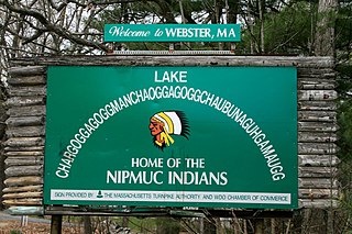
Webster is a town in Worcester County, Massachusetts. The population was 17,776 at the 2020 census.

<span class="mw-page-title-main">Housatonic River</span> River in the northeastern U.S.

The Housatonic River is a river, approximately 149 miles (240 km) long, in western Massachusetts and western Connecticut in the United States. It flows south to southeast, and drains about 1,950 square miles (5,100 km2) of southwestern Connecticut into Long Island Sound.

<span class="mw-page-title-main">Massachusett language</span> Indigenous Algonquian language spoken in the Northeastern United States

The Massachusett language is an Algonquian language of the Algic language family that was formerly spoken by several peoples of eastern coastal and southeastern Massachusetts. In its revived form, it is spoken in four communities of Wampanoag people. The language is also known as Natick or Wôpanâak (Wampanoag), and historically as Pokanoket, Indian or Nonantum.

<span class="mw-page-title-main">Nipmuc</span> Indigenous people in Massachusetts and adjoining states

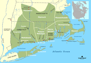
The Nipmuc or Nipmuck people are an Indigenous people of the Northeastern Woodlands, who historically spoke an Eastern Algonquian language. Their historic territory Nippenet, "the freshwater pond place," is in central Massachusetts and nearby parts of Connecticut and Rhode Island.

<span class="mw-page-title-main">Praying town</span> Settlements established in New England

Praying towns were settlements established by English colonial governments in New England from 1646 to 1675 in an effort to convert local Native Americans to Christianity.

<span class="mw-page-title-main">Millers River</span> River in Massachusetts, United States

The Millers River is a 52.1-mile-long (83.8 km) river in northern Massachusetts, originating in Ashburnham and joining the Connecticut River just downstream from Millers Falls, Massachusetts. Sections of the river are used for whitewater kayaking, and a section upriver is popular with flatwater racers, and the river is known locally as a good place for pike fishing.

<span class="mw-page-title-main">Hassanamisco Nipmuc</span>

The Hassanamisco Nipmuc Band is the sole state-recognized tribe in the Commonwealth of Massachusetts. They were recognized in 1976 by Governor Michael Dukakis via Executive Order 126. They were briefly known as the Nipmuc Nation, a union of the Hassanamisco Nipmuc and the Chaubunagungamaug Nipmuck bands, during their attempt to receive federal acknowledgment as a Nation. The Hassanamisco Nipmuc Band owns three and a half acres of reservation land in what is present day Grafton, Massachusetts. The Nipmuc are native to Central Massachusetts, Northeastern Connecticut, and parts of Rhode Island.

<span class="mw-page-title-main">Webster/Dudley Band of Chaubunagungamaug Nipmuck Indians</span>

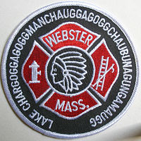
The Webster/Dudley Band of Chaubunagungamaug Nipmuck Indians, also known as the Chaubunagungamaug, Chaubunagungamaug Nipmuck, Pegan or Dudley/Webster Indians, is a cultural heritage group that claims descent from the Nipmuc people. They are a state-recognized tribe by the Commonwealth of Massachusetts.

<span class="mw-page-title-main">Chaubunagungamaug Reservation</span> State Indian Reservation in Massachusetts, United States

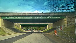
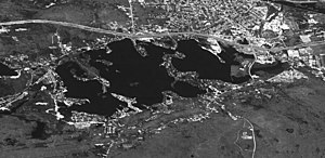
The Chaubunagungamaug Reservation refers to the small parcel of land located in the town of Thompson, Connecticut, close to the border with the town of Webster, Massachusetts, and within the bounds of Lake Chaubunagungamaug to the east and the French River to the west. The reservation is used by the descendants of the Nipmuck Indians of the previous reservation, c. 1682–1869, that existed in the same area, who now identify as the Webster/Dudley Band of the Chaubunagungamaug Nipmuck. Together with the Hassanamisco Nipmuc, both have received state recognition under the Massachusetts Commission on Indian Affairs.

<span class="mw-page-title-main">Quinebaug River</span> River in Massachusetts, United States

The Quinebaug River is a river in south-central Massachusetts and eastern Connecticut, with watershed extending into western Rhode Island. The name "Quinebaug" comes from the southern New England Native American term, spelled variously Qunnubbâgge, Quinibauge, etc., meaning "long pond", from qunni-, "long", and -paug, "pond". The river is one of the namesake rivers in the Quinebaug and Shetucket Rivers Valley National Heritage Corridor.

<span class="mw-page-title-main">French River (Massachusetts)</span> River in Massachusetts and Connecticut, United States

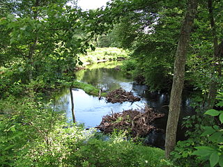
The French River is a river in south-central Massachusetts and northeastern Connecticut, USA.

<span class="mw-page-title-main">Watuppa Ponds</span>

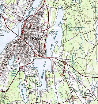
The Watuppa Ponds are two large, naturally occurring, spring-fed, glacially formed ponds located in Fall River and Westport, Massachusetts. Watuppa is a native word meaning "place of boats". The two ponds were originally one body of water, connected by a narrow rocky straight called "The Narrows" located on a thin strip of land between the two ponds which forms part boundary of between Fall River and Westport. The border between Fall River and Westport is also divided between the two ponds. Together, the ponds have an overall north–south length of about 7.5 miles, and have an average east–west width of about a mile. The ponds are drained by the Quequechan River, and flows in a westerly direction through the center of Fall River from South Watuppa Pond to Mount Hope Bay.

Quinsigamond is a place in Massachusetts.

Massachusett is an indigenous Algonquian language of the Algic language family. It was the primary language of several peoples of New England, including the Massachusett in the area roughly corresponding to Boston, Massachusetts, including much of the Metrowest and South Shore areas just to the west and south of the city; the Wampanoag, who still inhabit Cape Cod and the Islands, most of Plymouth and Bristol counties and south-eastern Rhode Island, including some of the small islands in Narragansett Bay; the Nauset, who may have rather been an isolated Wampanoag sub-group, inhabited the extreme ends of Cape Cod; the Coweset of northern Rhode Island; and the Pawtucket which covered most of north-eastern Massachusetts and the lower tributaries of the Merrimack River and coast of New Hampshire, and the extreme southernmost point of Maine. Massachusett was also used as a common second language of peoples throughout New England and Long Island, particularly in a simplified pidgin form.

The Massachusett dialects, as well as all the Southern New England Algonquian (SNEA) languages, could be dialects of a common SNEA language just as Danish, Swedish and Norwegian are mutually intelligible languages that essentially exist in a dialect continuum and three national standards. With the exception of Massachusett, which was adopted as the lingua franca of Christian Indian proselytes and survives in hundreds of manuscripts written by native speakers as well as several extensive missionary works and translations, most of the other SNEA languages are only known from fragmentary evidence, such as place names. Quinnipiac (Quiripey) is only attested in a rough translation of the Lord's Prayer and a bilingual catechism by the English missionary Abraham Pierson in 1658. Coweset is only attested in a handful of lexical items that bear clear dialectal variation after thorough linguistic review of Roger Williams' A Key into the Language of America and place names, but most of the languages are only known from local place names and passing mention of the Native peoples in local historical documents.

Black James was a Nipmuc constable and spiritual leader of the Chaubunagungamaug Nipmuck at the Chaubunagungamaug Reservation in colonial Massachusetts and Connecticut. Daniel Gookin appointed James to be a constable for the praying towns after he had become a Christian. In 1675, James signed a treaty agreeing not to assist King Philip, but may have supported him during King Philip's War. After the War, Black James deeded various parcels of land to settlers in Nipmuc country including at Quantisset and Maanexit in what is now eastern Connecticut near Rhode Island. His dying speech was recorded by Rev. Daniel Takawambait and later published and by 1686 a deed was signed by his heirs indicating that Black James was deceased, but another Indian used the name "Black James" until 1708.

References

  1. 1 2 Patenaude, Ed (June 28, 2001). "Fabrication leaves us gasping - Old twist to name of lake comes to light". Worcester Telegram & Gazette. Archived from the original on July 23, 2003. Retrieved May 31, 2011.
  2. 1 2 3 4 Goddard, Ives. "Time to Retire an Indian Place-Name Hoax", The New York Times (Letter to Editor; September 29, 1990).
  3. "Lake Chaubunagungamaug". Geographic Names Information System . United States Geological Survey, United States Department of the Interior . Retrieved April 14, 2011.
  4. 1 2 3 Old Webster History Archived May 14, 2011, at the Wayback Machine , from the Webster TIMES Centennial Anniversary Issue, 1859-1959.
  5. Trumbull, James Hammond. 1881. Indian Names of Places etc., In and On the Borders of Connecticut: With interpretations of Some of Them. Reprinted in facsimile 1974 under title Indian Names in Connecticut by Archon Books, Hamden, Conn.
  6. Goddard, Ives. 1974. Untitled review of Trumbull in International Journal of American Linguistics Vol. 43, No. 2 (Apr., 1977), pp. 157–159, University of Chicago Press.
  7. Osgood, Carleton (1795). "An accurate map of the Commonwealth of Massachusetts..." Boston Public Library.
  8. "AUDIO: Singing a Name That's Hard to Say", New York Times (November 19, 2004).
  9. "OldeWebster Photo Archive" Archived December 13, 2007, at the Wayback Machine (Accessed September 16, 2015).
  10. Ash, Russell (November 10, 2011). Boring, Botty and Spong. RHCP. p. 68. ISBN   978-1-4090-9739-6.
  11. Town of Webster, accessed January 15, 2007.
  12. Knapton, Sarah (April 22, 2009). "Longest Place Name in US Spelt Wrongly". The Telegraph. London. Retrieved March 28, 2012.
  13. Brian Lee (April 14, 2009). "Misspelling on Lake Signs to Get Overdue Correction". Worcester Telegram & Gazette.
  14. Nipmuc Place Names of New England
  15. "Webster Lake", Division of Fisheries and Wildlife, Commonwealth of Massachusetts (February 1998), via Archive.org
  16. "Webster Lake Cyanobacteria Investigation: Phase I" Archived March 4, 2016, at the Wayback Machine , Prepared by Water Resource Services, Inc., for the Webster Lake Association (November 2014).
  17. 1 2 3 "About Webster Lake" Archived May 21, 2019, at the Wayback Machine , Webster Lake Association. Accessed September 6, 2015.
  18. Poem by Bertha A. Joslin Archived August 15, 2020, at the Wayback Machine .