
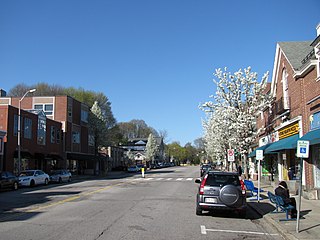
Cambridge is a city in Middlesex County, Massachusetts, in the United States. It is a major suburb in the Greater Boston metropolitan area, located directly across the Charles River from Boston. The city's population as of the 2020 U.S. census was 118,403, making it the largest city in the county, the fourth most populous city in the state, behind Boston, Worcester, and Springfield, and ninth most populous city in New England. It was named in honor of the University of Cambridge in England, which was an important center of the Puritan theology that was embraced by the town's founders.

North Attleborough, alternatively spelled North Attleboro, is a town in Bristol County, Massachusetts, United States. The population was 30,834 at the 2020 United States Census.

Ashby is a town in Middlesex County, Massachusetts, United States. The population was 3,193 at the 2020 census, which makes it the least populous municipality in Middlesex County. The Town of Ashby is primarily a bedroom community consisting almost entirely of single family homes and a limited number of businesses.

Bedford is a town in Middlesex County, Massachusetts, United States. The population of Bedford was 14,383 at the 2020 United States census.

Stow is a town in Middlesex County, Massachusetts, United States. The town is located 21 miles (34 km) west of Boston, in the MetroWest region of Massachusetts. The population was 7,174 at the 2020 United States Census. Stow was officially incorporated in 1683 with an area of approximately 40 square miles (100 km2). Over centuries it gave up land as newer, smaller towns were created, ceding land to Harvard (1732), Shirley (1765), Boxborough (1783), Hudson (1866) and Maynard (1871). Stow now has an area of 18.1 square miles (47 km2). With the exception of factories at Assabet Village and Rock Bottom, Stow was primarily sparsely settled farm and orchard land until the 1950s.

Tewksbury is a town in Middlesex County, Massachusetts, United States. Its population was 31,342 as of the 2020 United States Census.

Millis is a town in Norfolk County in the U.S. state of Massachusetts. It had a population of 8,460 at the 2020 census. The town is approximately 19 miles (31 km) southwest of downtown Boston and is bordered by Norfolk, Sherborn, Holliston, Medfield, and Medway. Massachusetts state routes 109 and 115 run through Millis.

Arlington is a town in Middlesex County, Massachusetts. The town is six miles (10 km) northwest of Boston, and its population was 46,308 at the 2020 census.
Belmont is a town in Middlesex County, Massachusetts, United States. It is a western suburb of Boston, Massachusetts, United States; and is part of the Greater Boston metropolitan area. At the 2020 U.S. census, its population was 27,295, up 10.4% from 2010.

Burlington is a town in Middlesex County, Massachusetts, United States. The population was 26,377 at the 2020 census.

Hanson is a town in Plymouth County, Massachusetts, United States. Part of Greater Boston, Hanson is located 20 miles (32 km) south of Boston and is one of the inland towns of the South Shore. The population was 10,639 at the 2020 census.

The Raritan River Rail Road was a 12-mile (19 km) shortline railroad in Middlesex County, New Jersey U.S., Founded in 1888, it was based in South Amboy, from which it ran west as far as New Brunswick. It served both passengers and freight in its heyday and operated profitably throughout much of its existence. The Raritan River was absorbed into Conrail in 1980, becoming a branch line of Conrail Shared Assets Operations. It terminates at U.S. Route 1 in North Brunswick.

The Assabet River is a small, 34.4-mile (55.4 km) long river located about 20 miles (30 km) west of Boston, Massachusetts, United States. The Assabet rises from a swampy area known as the Assabet Reservoir in Westborough, Massachusetts, and flows northeast before merging with the Sudbury River at Egg Rock in Concord, Massachusetts, to become the Concord River. The Organization for the Assabet, Sudbury and Concord Rivers, headquartered in West Concord, Massachusetts, is a non-profit organization dedicated to the preservation, protection, and enhancement of the natural and recreational features of these three rivers and their watershed. As the Concord River is a tributary of the Merrimack River, it and the Assabet and Sudbury rivers are part of the larger Merrimack River watershed.

Alewife Brook Reservation is a Massachusetts state park and urban wild located in Cambridge, Arlington, and Somerville. The park is managed by the state Department of Conservation and Recreation and was established in 1900. It is named for Alewife Brook, which was also historically known as Menotomy River, a tributary of the Mystic River.

Belmont High School is a four-year public high school in Belmont, Massachusetts, United States. The new school building was opened in 2021. The school had 1,309 students enrolled and a student/teacher ratio of 16.8:1 in the 2020–2021 school year.

Mother Brook is a stream that flows from the Charles River in Dedham, Massachusetts, to the Neponset River in the Hyde Park section of Boston, Massachusetts. Mother Brook was also known variously as East Brook and Mill Creek in earlier times. Digging the brook made Boston and some surrounding communities an island, accessible only by crossing over water, making Mother Brook "Massachusetts' Panama Canal."
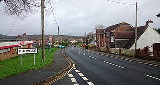
Gunville is a small settlement on the Isle of Wight, off the south coast of England. It largely comprises housing, although there are also a small number of shops, a couple of charity shops, some retail warehouses, a snooker hall, Methodist Church and a fishing lake. The settlement seems to date from some time after 1800, although the vast majority of the buildings currently standing in Gunville date from after 1900.
Vine Brook is a brook in Middlesex County, United States. According to the History of Bedford, Vine Brook is "an important tributary of Shawsheen River." The book also states it as an excellent source of water-power in the 17th to 19th Centuries.
Crossley is an unincorporated community and ghost town located within Berkeley Township in Ocean County, New Jersey, United States. It is located along an abandoned Penn Central rail line, approximately 5 mi (8.0 km) west of Toms River CDP.

Heards Brook is a stream in Woodbridge Township, Middlesex County, New Jersey, United States.


