
Lacamas Lake is a small lake in Clark County, Washington. It is a popular place to fish and water ski for locals from Vancouver, Camas and Washougal. It connects to Round Lake via a channel that runs under the SR 500 bridge on the southeast side of the lake. In the 1990s many high tech manufacturing plants and expensive housing developments began to appear in the area around the lake. The lake is very warm compared to other lakes in the area and the temperature can drop off quickly with depth. As it is now, the 60-foot-deep (18 m) lake cannot support life below about 18 ft (5.5 m). The Georgia-Pacific Mill in Camas used to draw water from the lake to support its operations; however, Georgia-Pacific donated the two dams on Round Lake to the City of Camas in 2018.

Donner Lake, formerly known as Truckee Lake, is a freshwater lake in Northeast California on the eastern slope of the Sierra Nevada and about 20 miles (32 km) northwest of the much larger Lake Tahoe. A moraine serves as a natural dam for the lake. The lake is located in the town of Truckee, between Interstate 80 to the north and Schallenberger Ridge to the south. The tracks of the Union Pacific Railroad run along Schallenberger Ridge and closely follow the route of the original transcontinental railroad. The historic route of the Lincoln Highway, the first automobile road across America and US 40 follows the northern shoreline, then climbs to Donner Pass from where the entire lake may be viewed.
Lake Attitash is a lake located on the border of Merrimac, Massachusetts and Amesbury, Massachusetts, and constitutes at least a portion of Amesbury's water supply.

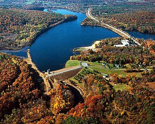
Greers Ferry Lake is the reservoir formed by Greers Ferry Dam, a United States Army Corps of Engineers dam in Northern Arkansas. It is located about 60 miles (100 km) north of Little Rock.
Trickey Pond is a water body in the U.S. state of Maine. Its maximum depth is 55 feet (17 m). The lack of serious pollution in the area contributes to the pond's remarkably good water clarity. At most points in the pond, the entire depth can be seen.

Browning Pond is located in Oakham and Spencer, Massachusetts. This 89-acre (360,000 m2) great pond forms the headwaters of the Seven Mile River. It is part of the Chicopee River Watershed.

Madge Lake is a freshwater lake located in eastern Saskatchewan, 18 km east of the town of Kamsack and just a few kilometres west of the province's eastern boundary. Road access to the lake is via Highway 57, which passes by the south shore of Madge Lake as it connects Highway 5 to Manitoba Highway 83.

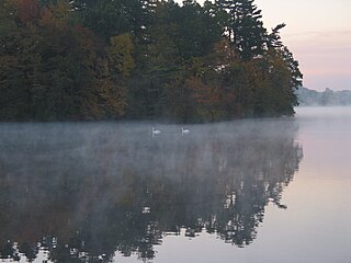
Billington Sea is a 269-acre (1.09 km2) warm water pond located in Plymouth, Massachusetts. Morton Park lies on the pond's northern shore. The pond is fed by groundwater and cranberry bog outlets. The average depth is seven feet and the maximum depth is 11 feet (3.4 m). The pond provides the headwaters to Town Brook. Seymour Island is located in the center of the pond. Billington Sea was named after its discoverer, Francis Billington, one of the passengers on the Mayflower.
Monponsett Pond, also called Monponsett Lake and the Twin Lakes, originally one lake is dissected by route 58 into a system of two ponds, West and East, mostly in Halifax, Massachusetts, with a small portion of West Monponsett Pond extending into Hanson. The western basin is 308 acres (1.25 km2), and the eastern basin is 272 acres (1.10 km2). The average depth of both ponds is seven feet and the maximum depth is 13 feet (4.0 m). The outflow is Stump Brook, located in the northwestern part of West Monponsett Pond, which flows in a southwest direction into Robbins Pond, which forms the headwaters of the Sautucket River, a tributary of The Taunton River. The pond is part of the Taunton River Watershed. Water from Monponsett is diverted into Silver Lake, the principal water supply for the City of Brockton. Water diversions from Monponsett into Silver lake are not permitted during the summer months from June 1 - September 30. Diversions are only allowed during the months of October through May.
The East Brimfield Dam is located on the Quinebaug River in Sturbridge, Massachusetts, approximately 20 miles (32 km) southwest of Worcester, Massachusetts.
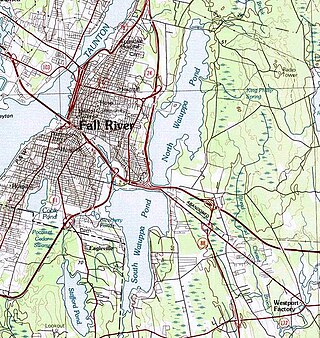
The Watuppa Ponds are two large, naturally occurring, spring-fed, glacially formed ponds located in Fall River and Westport, Massachusetts. Watuppa is a native word meaning "place of boats". The two ponds were originally one body of water, connected by a narrow rocky strait called "The Narrows" located on a thin strip of land between the two ponds which forms part boundary of between Fall River and Westport. The border between Fall River and Westport is also divided between the two ponds. Together, the ponds have an overall north–south length of about 7.5 miles, and have an average east–west width of about a mile. The ponds are drained by the Quequechan River, and flows in a westerly direction through the center of Fall River from South Watuppa Pond to Mount Hope Bay.
Lake Cochituate is a body of water in Natick, Wayland, and Framingham, Massachusetts, United States. Originally a reservoir serving Boston, it no longer serves that function, and is now a local recreational resource and home to Cochituate State Park.

Karkarook Park is a metropolitan park in Melbourne, Victoria, Australia, located at the northwest corner of the southeastern suburb of Heatherton, southeast of the intersection between Warrigal Road and Dingley Bypass, accessible to cars only via Fairchild Street on the south side. The park is a wetland reserve built around the Karkarook Lake, a 15 hectares, 420 m (1,380 ft) wide artificial lake built from a pit created by sand mining between 1997 and 2001, filled in 2004 by groundwater pumped from a bore 500 metres (550 yd) to the southeast.

Lake Sunapee is located within Sullivan County and Merrimack County in western New Hampshire, the United States. It is the fifth-largest lake located entirely in New Hampshire.

Blue Lake Regional Park is a public park in Fairview, in the U.S. state of Oregon. The 101-acre (41 ha) park, near the south shore of the Columbia River in Multnomah County, includes many covered and uncovered picnic areas, playing fields for sports such as softball, a cross country course and infrastructure related to lake recreation including swimming, boating, and fishing. Encompassing wooded areas, three ponds, and a wetland in addition to the lake, the park is frequented by migrating birds and other wildlife. Paved paths run through the park, which is near the 40-Mile Loop hiking and biking trail. Park vegetation includes cottonwoods, willows, and other trees and shrubs as well as wetland plants such as cattails.
Sylvan Lake is located next to the community by that name in the Town of Beekman, New York, United States. It is the deepest and second-largest lake in Dutchess County.

Mashapaug Lake is a 297-acre (1.20 km2) lake surrounded by Bigelow Hollow State Park and Nipmuck State Forest in the town of Union in northeastern Connecticut. The lake has a maximum depth of 39.5 feet, and an average depth of 15 feet. Its normal surface elevation is 706 feet (215 m). The lake is very popular with fishermen and boaters from the area, and can also be used for swimming.
Unity Pond (Lake Winnecook) is the largest lake in Waldo County, Maine. It is within the towns of Unity, Burnham, and Troy. The main tributaries are Meadow Brook, Bithers Brook, and Carlton Stream. The sole outflow is Twenty-Five Mile Stream, via a wetlands to the southwest of the lake, which in turn feeds into the Sebasticook River. The lake is surrounded by almost 300 residences, of which slightly more than half are seasonal. It is also used for boating, fishing, camping, and swimming. Kanokolus Beach on the southwest shore and Burnham Town Beach are both open to the public.

Willard Pond is a small, protected lake in Antrim, New Hampshire, United States. The lake, located in southwestern New Hampshire, is about 108 acres (44 ha) in size with an average depth of 25 feet (7.6 m) and a maximum depth of 58 feet (18 m). No petroleum motors are allowed, and fly fishing is the only form of fishing allowed. It is part of the dePierrefeu Wildlife Sanctuary, which is owned by the New Hampshire Audubon Society. Because the pond and the land around it are part of the sanctuary, the shore is unable to be developed. Therefore, there are no buildings around the pond and there won't be any in the foreseeable future. Willard is instead surrounded by extensive amounts of wilderness and hiking trails that lead around the pond and to the summits of Bald Mountain and Goodhue Hill. Willard is a popular fishing, boating and hiking destination, and it has become more popular with its mention in numerous magazines and newspapers.

Beech Hill Pond is a lake in Otis, Hancock County, Maine, in the United States. It is 4.5 miles (7.2 km) long, half a mile wide, and up to 104 feet (32 m) deep. Trout, salmon, and other species of fish have been observed in the lake. Bald eagles and loons also live on the shoreline.


