External links
| This Plymouth County, Massachusetts geography–related article is a stub. You can help Wikipedia by expanding it. |
| Elbow Pond | |
|---|---|
| Location | Plymouth, Massachusetts |
| Coordinates | 41°48′18″N70°34′48″W / 41.80500°N 70.58000°W Coordinates: 41°48′18″N70°34′48″W / 41.80500°N 70.58000°W |
| Basin countries | United States |
| Surface area | 16 acres (6.5 ha) |
| Settlements | Cedarville |
Elbow Pond is a 16-acre (65,000 m2) pond in the Cedarville section of Plymouth, Massachusetts. The pond is located south of Island Pond and west of Great Herring Pond.
| This Plymouth County, Massachusetts geography–related article is a stub. You can help Wikipedia by expanding it. |

Haggetts Pond is the reservoir for the town of Andover, Massachusetts, United States. It is located in the western part of the town and also lends its name to a road. The Merrimack River is connected to the pond to add volume to the reservoir.
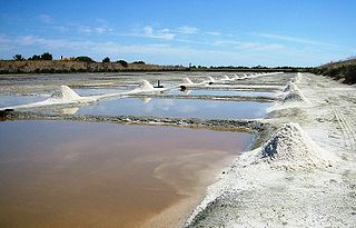
A salt evaporation pond is a shallow artificial salt pan designed to extract salts from sea water or other brines. Natural salt pans are geological formations that are also created by water evaporating and leaving behind salts. Some salt evaporation ponds are only slightly modified from their natural version, such as the ponds on Great Inagua in the Bahamas, or the ponds in Jasiira, a few kilometres south of Mogadishu, where seawater is trapped and left to evaporate in the sun.

Moxie Falls is a waterfall in Somerset County, Maine. At a vertical drop of over 90 feet (30 m) into a pool about 17 feet (5 m) deep, Moxie Falls is one of the highest falls in New England. The falls are part of Moxie Stream which flows from Moxie Pond into the Kennebec River approximately 1 kilometer (0.62 mi) downstream the falls. Moxie Stream drains Moxie Pond approximately 5 miles (8.0 km) upstream of the falls.

The Five Mile River is a 10.1-mile-long (16.3 km) river in central Massachusetts, part of the Chicopee River watershed. It rises north of Dean Pond in the Town of Oakham within Rutland State Forest and flows south through Dean Pond to Brooks Pond, 2.5 miles (4.0 km) northeast of North Brookfield, then continues south to its mouth at the north end of Lake Lashaway, also in North Brookfield.
Great South Pond is a 292-acre (1.2 km2) reservoir in Plymouth, Massachusetts, in South Pond village. The pond is within the Eel River watershed, located southeast of Little South Pond, west of South Triangle Pond, and north of Boot Pond. The pond serves as a secondary municipal water supply for the Town of Plymouth.
Gunners Exchange Pond is a 29-acre (120,000 m2) pond in the southern part of South Pond village in Plymouth, Massachusetts within the Eel River watershed, southeast of Boot Pond, southwest of Island Pond, and northeast of Myles Standish State Forest. The outflow is Hoyts Pond, which is connected to Gunners Exchange Pond.
South Triangle Pond is a 15-acre (61,000 m2) pond in Plymouth, Massachusetts within the Eel River watershed. The pond is located north of South Pond village in the Plymouth Town Forest, east of Great South Pond and south of Plymouth's main Post Office and The Shops at 5.
Island Pond is a 12-acre (49,000 m2) pond in the South Pond section of Plymouth, Massachusetts, one of three ponds named Island Pond within the town. The pond is part of the Eel River watershed. The pond is located northeast of Gunners Exchange Pond and Hoyts Pond, and north of Myles Standish State Forest.
Black Jimmy Pond, also known as Hyles Pond, is an 11-acre (45,000 m2) pond in the Cedarville section of Plymouth, Massachusetts. The pond is located northwest of Hedges Pond and northeast of Little Herring Pond. "Black Jimmy" was a resident at the house across the pond. During his residency he killed his wife. He then on the south side of the Pond set up a table and hanged himself. Today many witnesses have seen the ghost of "Black Jimmy's" wife in the Browning Lodge.
Harrobs Corner Bog Pond is a 16-acre (65,000 m2) pond in Plympton, Massachusetts. The pond is located in the North Plympton section of the town north of Harrobs Corner off Route 106 and Lake Street, and south of Silver Lake village. The pond is hydrologically associated with a cranberry bog operation located to the northeast of the pond. An unnamed brook heading south toward Jones River Creek, a tributary of the Jones River, is the outflow of the pond. The water quality is impaired due to non-native aquatic plants in the pond.
Island Creek Pond is a 43-acre (170,000 m2) pond in Duxbury, Massachusetts in the village of Tinkertown. The pond is located north of Mill Pond, south of North Hill Marsh Pond, and southwest of Pine Lake and Round Pond. The pond is the headwaters to Island Creek. The water quality is impaired due to non-native aquatic plants and non-native fish in the pond. Crocker Park, an open space area owned by the Town of Duxbury, is situated along the southern shore of the pond.
Reeds Millpond is a 10-acre (40,000 m2) pond in Kingston, Massachusetts. The pond is located on Route 27 northwest of the intersection with Winter Street and Reed Street, north of Pembroke Street South Pond, south of Lower Chandler Pond and southwest of Pine Street Pond. Pine Brook, a tributary of the Jones River, flows through the pond. The water quality is impaired due to non-native aquatic plants and non-native fish in the pond.

Mill Pond is a 13-acre (53,000 m2) pond in Duxbury, Massachusetts in the village of Island Creek. The pond is located south of Island Creek Pond. Island Creek runs through the pond. Route 3A runs along the southern shore of the pond. The water quality is impaired due to non-native aquatic plants in the pond. The fishway at the Mill Pond dam has deteriorated and no longer functions.

Jacobs Pond is a 59-acre (240,000 m2) pond in Norwell, Massachusetts. The pond is located alongside Assinippi, a village in neighboring Hanover. Route 123 runs along the southern shore of the pond. The pond is the headwaters of Third Herring Brook, a tributary of the North River which is the town line between Norwell and the eastern boundary of Hanover. The water quality is impaired due to non-native aquatic plants and non-native fish in the pond. The South Shore Natural Science Center is located near this pond.

The Watuppa Ponds are two large, naturally occurring, spring-fed, glacially formed ponds located in Fall River and Westport, Massachusetts. Watuppa is a native word meaning "place of boats". The two ponds were originally one body of water, connected by a narrow rocky straight called "The Narrows" located on a thin strip of land between the two ponds which forms part boundary of between Fall River and Westport. The border between Fall River and Westport is also divided between the two ponds. Together, the ponds have an overall north-south length of about 7.5 miles, and have an average east-west width of about a mile. The ponds are drained by the Quequechan River, and flows in a westerly direction through the center of Fall River from South Watuppa Pond to Mount Hope Bay.

Piccaninnie Ponds Conservation Park, formerly the Piccaninnie Ponds National Park, is a protected area of 862 hectares located in southeastern South Australia near Mount Gambier.

The Moose River is an 83-mile-long (134 km) river in Maine. Its source is in Beattie, on the Canada–United States border, which runs along the height of land between the watersheds of the Kennebec River in Maine and the Chaudière River in Quebec. From there, the river runs east through Attean Pond and Wood Pond, past the town of Moose River, then through Long Pond and Brassua Lake. The Moose River empties into Moosehead Lake, the source of the Kennebec River, in Rockwood Strip. The International Railway of Maine was built along Moose River in 1889.
The Sebec River is a tributary of the Piscataquis River in Piscataquis County, Maine. From the outflow of Sebec Lake in Sebec, the river runs 10.0 miles (16.1 km) east and southeast to its confluence with the Piscataquis in Milo.

Eden Landing Ecological Reserve is a nature reserve in Hayward and Union City, California, on the eastern shore of San Francisco Bay. The reserve is managed by the California Department of Fish and Game and comprises 5,040 acres of former industrial salt ponds now used as a low salinity waterbird habitat. It lies between the Hayward Regional Shoreline and Alameda Creek Regional Trail to the north and adjacent to Don Edwards National Wildlife Refuge and Coyote Hills Regional Park to the south and is south and adjacent to the San Mateo–Hayward Bridge, across which lies the Hayward Shoreline Interpretive Center. Some waterfowl hunting is periodically permitted. The remains of the Oliver Salt Company are located in the reserve.

Ewens Ponds Conservation Park is a protected area in the Australian state of South Australia consisting of the Ewens Ponds and some adjoining land in the gazetted locality of Eight Mile Creek about 8.4 kilometres east of Port MacDonnell in South Australia and about 25 kilometres south of Mount Gambier. The conservation park was proclaimed in 1976 under National Parks and Wildlife Act 1972. The conservation park was proclaimed for the following reasons:
The conservation park contains remnants of the terrestrial and aquatic vegetation communities which existed prior to clearing and development. The fauna within the conservation park is also relatively unique within South Australia and the physical features of the ponds are unique within Australia.