
Haverhill is a city in Essex County, Massachusetts, United States. Haverhill is located 35 miles (56 km) north of Boston on the New Hampshire border and about 17 miles (27 km) from the Atlantic Ocean. The population was 67,787 at the 2020 United States census.

Lake Rico, also known as Furnace Pond, is a 166-acre (0.67 km2) freshwater lake within Massasoit State Park in Taunton, Massachusetts. The lake takes up about nearly a quarter of Massasoit State Park. There are many coves, Much of its coastline is heavily forested, although there is a non-designated beach area located at Lake Rico's southeastern coast.
Massasoit State Park is a public recreation area located on the southeast side of the city of Taunton, Massachusetts, with some parklands spilling into the adjacent town of Lakeville. The state park encompasses more than 1200 heavily wooded acres that include six lakes and ponds and numerous cranberry bogs.

Watson Pond is a small freshwater lake within Watson Pond State Park, in Taunton, Massachusetts, United States. The lake is connected to Lake Sabbatia and much of its coastline is forested. The lake is open to the public for swimming and ice fishing.

Lake Sabbatia, sometimes known as Scaddings Pond is a 248-acre (100 ha) great pond in Taunton, Massachusetts, near Watson Pond State Park. The lake is where Mill River begins and the Snake River ends. It is the largest lake in the city of Taunton and the most popularly used. There are several coves and an island within the lake. Parts of its coastline are populated with woods, streets, and residential homes. Lake Sabbatia is used for a variety of recreational activities such as boating, swimming, fishing, and ice fishing. There is a boat ramp off Bay Street into the lake.

Ames Nowell State Park is a 700-acre (280 ha) state park located in Abington, Massachusetts, United States. The park is managed by the Department of Conservation and Recreation (DCR). There is also a lot of history in the park, with miles upon miles of stone walls, two wagon bridges, and two quarries all dating back to the 1600s and 1700s.

Brimfield State Forest is a Massachusetts state forest located in and around the town of Brimfield in Hampden County, Massachusetts. The forest includes Dean Pond Recreation Area, a popular spot for fishing, picnicking and swimming. The park is managed by the Department of Conservation and Recreation.

Dunn State Park is a public recreation area surrounding a 20-acre (8.1 ha) pond in Gardner, Massachusetts. The state park covers 132 acres (53 ha) and is managed by the Department of Conservation and Recreation.

Lake Dennison Recreation Area is a 121-acre (49 ha) Massachusetts state park located in the town of Winchendon. It comprises a small portion of the 4,221 acres (1,708 ha) of the U.S. Army Corps of Engineers' Birch Hill Flood Control Project that are managed by the Department of Conservation and Recreation and that also include Otter River State Forest.

Hopkinton State Park is a Massachusetts state park located in the towns of Hopkinton and Ashland and managed by the Department of Conservation and Recreation. The park was created after the Hopkinton Reservoir was removed from service as a water source for the Greater Boston area. In 2010, it was named as one of the 1,000 places to visit by the Great Places in Massachusetts Commission.
The East Brookfield River is a 2.4-mile-long (3.9 km) river in Massachusetts that heads at Lake Lashaway in East Brookfield at an elevation of 614 feet (187 m) above sea level. It continues to Quaboag Pond, at an elevation of 594 feet (181 m).

Wappinger Creek is a 41.7-mile-long (67.1 km) creek which runs from Thompson Pond to the Hudson River at New Hamburg in Dutchess County, New York, United States. It is the longest creek in Dutchess County, with the largest watershed in the county.
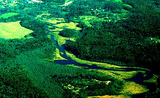
The Weymouth Back River, sometimes called Back River, is a short, primarily tidal river in Hingham and Weymouth, Massachusetts, about 10 miles (16 km) south of Boston. It arises from a number of tributaries in ponds and swamps, most notably Whitmans Pond, flows northward, and empties into Hingham Bay just south of Grape Island and Slate Island.
Lake Cochituate is a body of water in Natick, Wayland, and Framingham, Massachusetts, United States. Originally a reservoir serving Boston, it no longer serves that function, and is now a local recreational resource and home to Cochituate State Park.

Walker Pond is a body of water in Sturbridge, Massachusetts, situated off Route 49 on the way to Wells State Park.
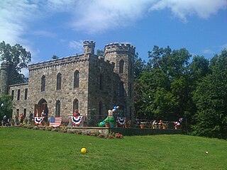
Winnekenni Castle is located in the over 700-acre Winnekenni Park Conservation Area, overlooking Kenoza Lake, in Haverhill, Massachusetts. Inspired by stone buildings he saw while visiting England, Haverhill chemist Dr. James R. Nichols built it between 1873 and 1875 as a summer home, and he named it and the surrounding land "Winnekenni," an Algonquin word meaning "very beautiful." It is one of the earliest works of Haverhill architect C. Willis Damon. The city of Haverhill purchased the castle in 1895, and in 1976, the city acquired 50.8 acres of conservation land between the Castle and Lake Saltonstall. The Castle's elaborate Victorian interior was destroyed by a fire in 1969, which led to the formation of the Winnekenni Foundation by a group of citizens. Today, the foundation is responsible for the upkeep of the castle and the surrounding land and trails. Under the direction and guidance of carpentry teacher Paul Crowley and carpentry students from Whittier Regional Vocational Technical High School, they were able to complete a refurbishing and remodeling of the building.

Clarksburg State Park is a 368-acre (149 ha) Massachusetts state park located in the town of Clarksburg. The park is made up of unspoiled northern hardwood forest, with views of the Hoosac Range, Mount Greylock and the Green Mountains. It is managed by the Department of Conservation and Recreation.
The Hubbard River, 4.6 miles (7.4 km) long, is part of the Farmington River watershed. It flows through Connecticut and Massachusetts.
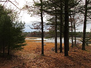
Willowdale State Forest is a Massachusetts state forest located in the towns of Hamilton, Topsfield, and Boxford. The area is managed by the Massachusetts Department of Conservation and Recreation. The forest's eastern portion sits on the Ipswich River across from Bradley Palmer State Park.


