New Hampton, New Hampshire | |
---|---|
Town | |
![]() New Hampton Community Church | |
![]() Location in Belknap County, New Hampshire | |
Coordinates: 43°36′19″N71°39′10″W / 43.60528°N 71.65278°W | |
Country | United States |
State | New Hampshire |
County | Belknap |
Incorporated | 1777 |
Government | |
• Board of Selectmen |
|
• Town Administrator | Corey Davenport |
Area | |
• Total | 38.4 sq mi (99.4 km2) |
• Land | 36.8 sq mi (95.2 km2) |
• Water | 1.6 sq mi (4.2 km2) 4.19% |
Elevation | 525 ft (160 m) |
Population (2020) [2] | |
• Total | 2,377 |
• Density | 65/sq mi (25.0/km2) |
Time zone | UTC-5 (Eastern) |
• Summer (DST) | UTC-4 (Eastern) |
ZIP code | 03256 |
Area code | 603 |
FIPS code | 33-51540 |
GNIS feature ID | 0873679 |
Website | www |
New Hampton is a town in Belknap County, New Hampshire, United States. The population was 2,377 at the 2020 census. [2] A winter sports resort area, New Hampton is home to George Duncan State Forest and to the New Hampton School, a private preparatory school established in 1821.
The primary village in town, where 373 people resided at the 2020 census, [3] is defined as the New Hampton census-designated place, and is located along New Hampshire Route 132, just south of its intersection with Route 104.
Granted in 1765 by colonial Governor Benning Wentworth, New Hampton was originally known as "Moultonborough Addition", after then-Colonel Jonathan Moulton, who held the position of town moderator. Moulton, who was born in Hampton, changed the name to New Hampton in 1777 when it was incorporated. [4]
In 1821 the New Hampton School, a Free Will Baptist institution, was founded in the town. From 1854 to 1870, the institute was affiliated with Cobb Divinity School (later part of Bates College).
In 1920, the New Hampton Fish Hatchery, the state's oldest fish hatchery, was established in the town.
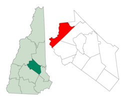
According to the United States Census Bureau, the town has a total area of 38.4 square miles (99.4 km2), of which 36.8 sq mi (95.2 km2) are land and 1.6 sq mi (4.2 km2) are water, comprising 4.19% of the town. [1] New Hampton is bounded on the west and southwest by the Pemigewasset River. Pemigewasset Lake is in the center, and Winona Lake and Lake Waukewan are in the northeast. The highest point in New Hampton is 1,840 feet (561 m) above sea level atop the west ridge of Hersey Mountain, whose 2,001-foot (610 m) summit lies just over the town boundary in Sanbornton.
The geographic center of New Hampshire is located in the eastern part of New Hampton, between Winona Lake and Jackson Pond, at 43.67925 N, 71.580375 W. [5]
The town is served by Interstate 93 and state routes 104 and 132. I-93 serves the town at Exit 23 and leads north to Plymouth and south to Concord. NH 104 passes east–west through the town, connecting Bristol to the west with Meredith to the east. NH 132 parallels I-93 as a local road, connecting Sanbornton and Tilton to the south with Ashland to the north.
Census | Pop. | Note | %± |
---|---|---|---|
1790 | 652 | — | |
1800 | 1,095 | 67.9% | |
1810 | 1,293 | 18.1% | |
1820 | 1,500 | 16.0% | |
1830 | 1,904 | 26.9% | |
1840 | 1,812 | −4.8% | |
1850 | 1,612 | −11.0% | |
1860 | 1,596 | −1.0% | |
1870 | 1,257 | −21.2% | |
1880 | 1,059 | −15.8% | |
1890 | 935 | −11.7% | |
1900 | 852 | −8.9% | |
1910 | 821 | −3.6% | |
1920 | 708 | −13.8% | |
1930 | 692 | −2.3% | |
1940 | 791 | 14.3% | |
1950 | 723 | −8.6% | |
1960 | 862 | 19.2% | |
1970 | 946 | 9.7% | |
1980 | 1,249 | 32.0% | |
1990 | 1,606 | 28.6% | |
2000 | 1,950 | 21.4% | |
2010 | 2,165 | 11.0% | |
2020 | 2,377 | 9.8% | |
U.S. Decennial Census [6] |
As of the 2010 census, there were 2,165 people, 848 households, and 617 families residing in the town. There were 1,083 housing units, of which 235, or 21.7%, were vacant. 185 of the vacant units were for seasonal or recreational use. The racial makeup of the town was 96.9% White, 0.4% African American, 0.1% Native American, 0.8% Asian, 0.0% Native Hawaiian or Pacific Islander, 0.05% some other race, and 1.8% from two or more races. 1.1% of the population were Hispanic or Latino of any race. [7]
Of the 848 households, 30.4% had children under the age of 18 living with them, 60.4% were headed by married couples living together, 7.5% had a female householder with no husband present, and 27.2% were non-families. 21.0% of all households were made up of individuals, and 8.2% were someone living alone who was 65 years of age or older. The average household size was 2.49, and the average family size was 2.86. [7]
In the town, 22.5% of the population were under the age of 18, 5.2% were from 18 to 24, 25.8% from 25 to 44, 31.1% from 45 to 64, and 15.5% were 65 years of age or older. The median age was 42.4 years. For every 100 females, there were 105.0 males. For every 100 females age 18 and over, there were 102.4 males. [7]
For the period 2011–2015, the estimated median annual income for a household was $74,009, and the median income for a family was $73,913. Male full-time workers had a median income of $49,138 versus $43,250 for females. The per capita income for the town was $28,267. 6.6% of the population and 3.3% of families were below the poverty line. 8.3% of the population under the age of 18 and 13.0% of those 65 or older were living in poverty. [8]
In the New Hampshire Senate, New Hampton is in the 2nd district, represented by Republican Bob Giuda. On the New Hampshire Executive Council, New Hampton is in the 1st district, represented by Republican Joseph Kenney. In the United States House of Representatives, New Hampton is in New Hampshire's 1st congressional district, represented by Democrat Chris Pappas.
New Hampton is within the Newfound Area School District. [9] New Hampton Community School is in New Hampton. The district's secondary schools are Newfound Memorial Middle School and Newfound Regional High School, both located in Bristol.
Belknap County is a county in the U.S. state of New Hampshire. As of the 2020 census, the population was 63,705. The county seat is Laconia. It is located in New Hampshire's Lakes Region, slightly southeast of the state's geographic center. Belknap County comprises the Laconia, NH Micropolitan Statistical Area, which in turn constitutes a portion of the Boston-Worcester-Providence, MA-RI-NH-CT Combined Statistical Area.
Barnstead is a town in Belknap County, New Hampshire, United States. The population was 4,915 at the 2020 census, up from 4,593 at the 2010 census. Home to the Suncook Lakes, Barnstead includes the villages of Center Barnstead, Barnstead Parade and South Barnstead.
Belmont is a town in Belknap County, New Hampshire, United States. The population was 7,314 at the 2020 census.
Gilford is a town in Belknap County, New Hampshire, United States. The population was 7,699 at the 2020 census, up from 7,126 at the 2010 census. Situated on Lake Winnipesaukee, Gilford is home to Governors Island, Ellacoya State Beach, Belknap Mountain State Forest, Gunstock Mountain Resort, and the Bank of New Hampshire Pavilion, a seasonal outdoor concert venue. The lakeside village of Glendale lies within Gilford's borders.
Sanbornton is a town in Belknap County, New Hampshire, United States. The population was 3,026 at the 2020 census. It includes the villages of North Sanbornton and Gaza.
Tilton is a town on the Winnipesaukee River in Belknap County, New Hampshire, United States. The population was 3,962 at the 2020 census, up from 3,567 at the 2010 census. It includes the village of Tilton and part of the villages of Winnisquam and Lochmere. Tilton is home to the Tilton School, a private preparatory school.
Alexandria is a town in Grafton County, New Hampshire, United States. The population was 1,776 at the 2020 census, up from 1,613 at the 2010 census. Newfound Lake is in the northeast corner, with Wellington State Park on the western shore. The town is home to Welton Falls State Forest. Cardigan Mountain State Park, with Mount Cardigan, is in the west. Another attraction is Mowglis Mountain, named for Rudyard Kipling's Jungle Book hero.
Ashland is a town in Grafton County, New Hampshire, United States. The population was 1,938 at the 2020 census, down from 2,076 at the 2010 census. Located near the geographical center of the state, Ashland is home to Scribner-Fellows State Forest.
Bridgewater is a town in Grafton County, New Hampshire, United States. The population was 1,160 at the 2020 census.
Groton is a town in Grafton County, New Hampshire, United States. The population was 569 at the 2020 census.
Hebron is a town in Grafton County, New Hampshire, United States, having a population of 632 as of the 2020 census. Settlements include the town center and the village of East Hebron.
Holderness is a town in Grafton County, New Hampshire, United States. The population was 2,004 at the 2020 census. An agricultural and resort area, Holderness is home to the Squam Lakes Natural Science Center and is located on Squam Lake. Holderness is also home to Holderness School, a co-educational college-preparatory boarding school.
Woodstock is a town in Grafton County, New Hampshire, United States. The population was 1,434 at the 2020 census. Woodstock includes the village of North Woodstock, the commercial center. Its extensive land area is largely forested, and includes the Hubbard Brook Experimental Forest. Parts of the White Mountain National Forest are in the east and west. The Appalachian Trail crosses the town's northwestern corner. Russell Pond Campground is in the east. West of North Woodstock is the Lost River Reservation.
Danbury is a town in Merrimack County, New Hampshire, United States. The population was 1,250 at the 2020 census.
Franklin is a city in Merrimack County, New Hampshire, United States. At the 2020 census, the population was 8,741, the lowest figure of New Hampshire's 13 cities. Franklin includes the village of West Franklin.
Hill is a town in Merrimack County, New Hampshire, United States. The population was 1,017 at the 2020 census. It is home to William Thomas State Forest.
Meredith is a town in Belknap County, New Hampshire, United States. The population was 6,662 at the 2020 census. Meredith is situated in the state's Lakes Region and serves as a major resort town. Meredith Village, the commercial center of the town, lies along the shores of Lake Winnipesaukee, and several other large lakes lie partially or completely within the town borders. It is home to the Stonedam Island Natural Area and the Winnipesaukee Scenic Railroad, and it serves as one of the ports of call for the MS Mount Washington.
Bristol is a census-designated place (CDP) and the main village in the town of Bristol in Grafton County, New Hampshire, United States. The population of the CDP was 1,911 at the 2020 census, out of 3,244 in the entire town.
Bristol is a town in Grafton County, New Hampshire, United States. The population was 3,244 at the 2020 census. It is home to Wellington State Park, Sugar Hill State Forest, and Profile Falls on the Smith River. Surrounded by hills and lakes, Bristol includes the lower two-thirds of Newfound Lake, a resort area.
New Hampton is a census-designated place (CDP) and the main village in the town of New Hampton in Belknap County, New Hampshire, United States. The population was 373 at the 2020 census, out of 2,377 people in the entire town of New Hampton.
coolidge mansfield history description new england 1859.