Stillwater River (Nashua River tributary)

Last updated
Stillwater River
Stillwater River Sterling Massachusetts.jpg
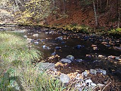
The Stillwater flowing through Sterling, Massachusetts
Location
CountryUnited States
Physical characteristics
Source 
  location Princeton, Massachusetts
  coordinates 42°27′48″N71°49′33″W / 42.4633°N 71.8258°W / 42.4633; -71.8258
  elevation720 ft (220 m)
Mouth  
  location
Wachusett Reservoir
  coordinates
42°24′05″N71°47′15″W / 42.4015°N 71.7874°W / 42.4015; -71.7874 Coordinates: 42°24′05″N71°47′15″W / 42.4015°N 71.7874°W / 42.4015; -71.7874
  elevation
384 ft (117 m)
Length8.1 miles (13.0 km)
Basin size39.3 sq mi (102 km2)
Discharge 
  average40 cu ft/s (1.1 m3/s)

The Stillwater River is part of the Nashua River watershed. This river is part of the Massachusetts Water Resources Authority system that supplies drinking water to the greater Boston area.

The Stillwater River rises in Princeton, Massachusetts, the watershed generally known as the Upper Worcester Plateau, or the Monadnock Upland. This watershed tops at Wachusett Mountain, the highest feature in the area. Water flowing east from this high ground feeds the Nashua River Watershed, and water flowing west feeds the Ware River or the Millers River, both heading to the Connecticut River. The Stillwater flows 8.1 miles (13.0 km) [1] through Princeton and Sterling before joining the Quinapoxet River at the Wachusett Reservoir in West Boylston to form the south branch of the Nashua River.

The Stillwater and Quinapoxet rivers are the two major tributaries to the Wachusett Reservoir, which serves as the primary source of water for 2.5 million consumers in 43 communities of central and eastern Massachusetts. The U.S. Geological Survey (USGS), in cooperation with the Massachusetts Department of Conservation and Recreation (DCR), operates stream-flow monitoring gages near the mouths of both rivers. This and other continuous monitoring serves to maintain the overall quality of water within the reservoir. The water of these tributaries to the Wachusett Reservoir has been of high quality for decades.

About 47% of the Stillwater sub-basin is permanently protected open space. The Massachusetts Water Resources Authority owns much of the land. The Town of Holden owns over 600 acres (2.4 km2) as the Trout Brook Conservation Area, and the Massachusetts Audubon Society owns several hundred acres in the Wachusett Meadow Wildlife Sanctuary in addition to other properties within this sub-basin.

Stillwater headwaters near Princeton StillwaterHeadwaters.jpg
Stillwater headwaters near Princeton

See also

Related Research Articles

West Boylston, Massachusetts Town in Massachusetts, United States

West Boylston is a town in Worcester County, Massachusetts, United States and a northern suburb of Worcester. The population was 7,877 at the 2020 census. West Boylston includes the village of Oakdale, located on the opposite side of the Wachusett Reservoir from West Boylston center along Route 140. Although the town was split off from Boylston, it has a larger population than its eastern namesake.

San Joaquin River Longest river of Central California, United States

The San Joaquin River is the longest river of Central California. The 366-mile (589 km) long river starts in the high Sierra Nevada, and flows through the rich agricultural region of the northern San Joaquin Valley before reaching Suisun Bay, San Francisco Bay, and the Pacific Ocean. An important source of irrigation water as well as a wildlife corridor, the San Joaquin is among the most heavily dammed and diverted of California's rivers.

Lackawanna River

The Lackawanna River is a 42-mile-long (68 km) tributary of the Susquehanna River in northeastern Pennsylvania in the United States. It flows through a region of the northern Pocono Mountains that was once a center of anthracite coal mining in the United States. It starts in north Wayne County, Pennsylvania and ends in east Luzerne County, Pennsylvania in Duryea, Pennsylvania. The lower reaches of the river flow through the urban areas of Scranton, which grew around its banks in the 19th century as an industrial center. Its name comes from a Lenni Lenape word meaning "stream that forks".

Bear River (Great Salt Lake) River in southwestern Wyoming, southeastern Idaho, and northern Utah

The Bear River is the largest tributary of the Great Salt Lake, draining a mountainous area and farming valleys northeast of the lake and southeast of the Snake River Plain. It flows through southwestern Wyoming, southeastern Idaho, and northern Utah, in the United States. Approximately 350 miles (560 km) long it is the longest river in North America that does not ultimately reach the sea.

Pit River River in California, United States

The Pit River is a major river draining from northeastern California into the state's Central Valley. The Pit, the Klamath and the Columbia are the only three rivers in the U.S. that cross the Cascade Range.

Feather River

The Feather River is the principal tributary of the Sacramento River, in the Sacramento Valley of Northern California. The river's main stem is about 73 miles (117 km) long. Its length to its most distant headwater tributary is just over 210 miles (340 km). The main stem Feather River begins in Lake Oroville, where its four long tributary forks join—the South Fork, Middle Fork, North Fork, and West Branch Feather Rivers. These and other tributaries drain part of the northern Sierra Nevada, and the extreme southern Cascades, as well as a small portion of the Sacramento Valley. The total drainage basin is about 6,200 square miles (16,000 km2), with approximately 3,604 square miles (9,330 km2) above Lake Oroville.

Nashua River River in Massachusetts and New Hampshire, United States

The Nashua River, 37.5 miles (60.4 km) long, is a tributary of the Merrimack River in Massachusetts and New Hampshire in the United States. It is formed in eastern Worcester County, Massachusetts, at the confluence of the North Nashua River and South Nashua River, and flows generally north-northeast past Groton to join the Merrimack at Nashua, New Hampshire. The Nashua River watershed occupies a major portion of north-central Massachusetts and a much smaller portion of southern New Hampshire.

Mount Wachusett is a mountain in Massachusetts. It straddles towns of Princeton and Westminster, in Worcester County. It is the highest point in Massachusetts east of the Connecticut River. The mountain is named after a Native American term meaning "near the mountain" or "mountain place". The mountain is a popular hiking and skiing destination. An automobile road, open spring to fall, ascends to the summit. Views from the top of Mount Wachusett include Mount Monadnock to the north, Mount Greylock to the west, southern Vermont to the northwest, and Boston to the east. The mountain is traversed by the 92 mi (148 km) Midstate Trail. It is also home to the Wachusett Mountain State Reservation.

Mokelumne River River in northern California

The Mokelumne River is a 95-mile (153 km)-long river in northern California in the United States. The river flows west from a rugged portion of the central Sierra Nevada into the Central Valley and ultimately the Sacramento–San Joaquin River Delta, where it empties into the San Joaquin River-Stockton Deepwater Shipping Channel. Together with its main tributary, the Cosumnes River, the Mokelumne drains 2,143 square miles (5,550 km2) in parts of five California counties. Measured to its farthest source at the head of the North Fork, the river stretches for 157 miles (253 km).

Wachusett Reservoir Second largest body of water in the state of Massachusetts

The Wachusett Reservoir is the second largest body of water in the state of Massachusetts. It is located in central Massachusetts, northeast of Worcester. It is part of the water supply system for metropolitan Boston maintained by the Massachusetts Water Resources Authority (MWRA). It has an aggregate capacity of 65 billion US gallons (250,000,000 m3) and an area of almost 7 square miles (18 km2). Water from the reservoir flows to the covered Norumbega Storage Facility via the Cosgrove Tunnel and the MetroWest Water Supply Tunnel. The reservoir has a maximum depth of 120 feet (37 m) and a mean depth of 48 feet (15 m).

Ware River River in United States of America

The Ware River is a 35.4-mile-long (57.0 km) river in central Massachusetts. It has two forks, both of which begin in Hubbardston, Massachusetts. The Ware River flows southwest through the middle of the state, joins the Quaboag River at Three Rivers, Massachusetts, to form the Chicopee River on its way to the Connecticut River.

Quinapoxet River

The Quinapoxet River is part of the Nashua River watershed in northern Massachusetts in the United States. It is part of the Massachusetts Water Resources Authority water system supplying drinking water to the greater Boston area.

San Juan Creek River in Orange County, California, United States

San Juan Creek, also called the San Juan River, is a 29-mile (47 km) long stream in Orange and Riverside Counties, draining a watershed of 133.9 square miles (347 km2). Its mainstem begins in the southern Santa Ana Mountains in the Cleveland National Forest. It winds west and south through San Juan Canyon, and is joined by Arroyo Trabuco as it passes through San Juan Capistrano. It flows into the Pacific Ocean at Doheny State Beach. San Juan Canyon provides a major part of the route for California State Route 74.

Wekepeke Aquifer in the United States

Wekepeke is the name of an aquifer and brook in Sterling, Massachusetts, United States. The aquifer has a land surface area of 11.5 square miles (30 km2).

San Diego Creek

San Diego Creek is a 16-mile (26 km) urban waterway flowing into Upper Newport Bay in Orange County, California in the United States. Its watershed covers 112.2 square miles (291 km2) in parts of eight cities, including Irvine, Tustin, and Costa Mesa. From its headwaters in Laguna Woods the creek flows northwest to its confluence with Peters Canyon Wash, where it turns abruptly southwest towards the bay. Most of the creek has been converted to a concrete flood control channel, but it also provides important aquatic and riparian habitat along its course and its tidal estuary.

Salmon Falls Creek River in Nevada and Idaho, United States

Salmon Falls Creek is a tributary of the Snake River, flowing from northern Nevada into Idaho in the United States. Formed in high mountains at the northern edge of the Great Basin, Salmon Falls Creek flows northwards 121 miles (195 km), draining an arid and mountainous basin of 2,103 square miles (5,450 km2). The Salmon Falls Creek valley served as a trade route between the Native American groups of the Snake River Plain and Great Basin. Today, most of its water is used for irrigation.

Middle Fork Eel River

The Middle Fork Eel River is a major tributary of the Eel River of northwestern California in the United States. It drains a rugged and sparsely populated region of the Yolla Bolly Mountains, part of the California Coast Range, in Trinity and Mendocino Counties. Its watershed comprises roughly 745 square miles (1,930 km2) of land, or 20% of the entire Eel River basin. The river provides groundwater recharge and is used for recreation and for industrial, agricultural and municipal water supply by residents.

Sudbury Reservoir

The Sudbury Reservoir is an emergency backup Boston metropolitan water reservoir in Massachusetts, located predominantly in Southborough and Marlborough, with small sections in Westborough and Framingham. It was created when the Sudbury Dam was constructed to impound the Stony Brook branch of the Sudbury River; no part of the reservoir lies in the town of Sudbury. Nearly 5,000 acres (2,000 ha) in the Sudbury Reservoir watershed are administered by the Massachusetts Department of Conservation and Recreation as a limited-access public recreation area.

Spring Brook (Lackawanna River tributary) River in the United States of America

Spring Brook is a tributary of the Lackawanna River in Lackawanna County and Luzerne County, in Pennsylvania, in the United States. It is approximately 17 miles (27 km) long and flows through Covington Township, Spring Brook Township, and Moosic in Lackawanna County and Pittston Township in Luzerne County. The watershed of the stream has an area of 57.2 square miles (148 km2). It is designated as a High-Quality Coldwater Fishery and a Migratory Fishery above Interstate 476 and as a Coldwater Fishery and a Migratory Fishery below it. A section is also designated as Class A Wild Trout Waters. The stream's tributaries include Panther Creek, Plank Bridge Creek, Rattlesnake Creek, Green Run, Monument Creek, and Covey Swamp Creek. It has a relatively high level of water quality and is very slightly acidic, with a pH of 6.4 to 6.9.

Lees Creek is a tributary of the Lackawanna River in Lackawanna County, Pennsylvania, in the United States. It is approximately 1.9 miles (3.1 km) long and flows through Carbondale Township. The watershed of the creek has an area of 0.73 square miles (1.9 km2). A reservoir known as the O and W Reservoir is located on it. The drainage basin of Lees Creek is designated as a Coldwater Fishery and a Migratory Fishery.

References

  1. U.S. Geological Survey. National Hydrography Dataset high-resolution flowline data. The National Map Archived 2012-03-29 at the Wayback Machine , accessed October 3, 2011