West Boylston, Massachusetts

Last updated

West Boylston, Massachusetts
WB Historical Soc.jpg
Bigelow Tavern (Historical Society)
Seal of West Boylston, Massachusetts.png
Motto(s): 
"Small Town, Big Heart" [1] The town motto was penned by Lionel Bella in 2010.
Worcester County Massachusetts incorporated and unincorporated areas West Boylston highlighted.svg
Location in Worcester County and the state of Massachusetts.
Coordinates: 42°22′00″N71°47′10″W / 42.36667°N 71.78611°W / 42.36667; -71.78611
CountryUnited States
State Massachusetts
County Worcester
Settled1642
Incorporated1808
Government
  Type Open town meeting
   Town
   Administrator
Jennifer Warren-Dyment
   Select Board Kristina Pedone, Chair
Patrick Crowley, Vice Chair
James Morrissey, Clerk
Barur R. Rajeshkumar
Marc Frieden
Area
  Total13.8 sq mi (35.8 km2)
  Land12.9 sq mi (33.4 km2)
  Water1.0 sq mi (2.5 km2)
Elevation
481 ft (147 m)
Population
 (2020)
  Total7,877
  Density570/sq mi (220/km2)
Time zone UTC−5 (Eastern)
  Summer (DST) UTC−4 (Eastern)
ZIP Code
01583
Area code 508/774
FIPS code 25-75155
GNIS feature ID0618391
Website www.westboylston-ma.gov

West Boylston is a town in Worcester County, Massachusetts, United States and a northern suburb of Worcester. The population was 7,877 at the 2020 census. West Boylston includes the village of Oakdale, located on the opposite side of the Wachusett Reservoir from West Boylston center along Route 140. Although the town was split off from Boylston, it has a larger population than its eastern namesake.

Contents

History

West Boylston was originally part of several neighboring towns—Lancaster, Shrewsbury, Boylston, Holden and Sterling. The town was created as part of a dispute between Boylston and West Boylston over the location of a new town meeting house. The town was officially incorporated in 1808.

During the 1800s the town grew with textile and other industries and became a prosperous community. This prosperity was interrupted as the town was selected as the site of the Wachusett Reservoir to provide water for Boston. It was selected due to its location at the junction of three rivers: the Quinapoxet River, the Stillwater River and the Nashua River. In 1897, the Nashua River in the town of Clinton was impounded by the Wachusett Dam, causing 6.5 square miles (17 km2) to be flooded in the towns of Boylston, West Boylston, Clinton and Sterling. Over 2,200 acres (8.9 km2) of West Boylston's land was used for the reservoir, the most of any town. This disrupted the center of town and most of the industrial base. Many buildings were moved to the unaffected parts of the town but the majority were demolished and filled by the reservoir. Over 1700 residents, 300 homes, eight schools, six mills, four churches and one hotel were moved to dry land. The state paid approximately 60 cents on the dollar for use of the land with the promise to pay $12,000 a year to the town for lost tax revenue forever. The reservoir was completed in 1905 and first filled in May 1908. West Boylston's prominent landmark, the Old Stone Church, was left remaining as a reminder of those that lost their homes and jobs to the building of the reservoir. It is one of the most photographed sites in the area.

Today, West Boylston has transformed itself into a bedroom community for Worcester and the surrounding region. Due to the reservoir, the town has been able to preserve much of its rural character, making it an attractive place for recreation and living.

West Boylston's most famous historical resident is Robert Bailey Thomas, the founder of the Old Farmer's Almanac .

Geography

According to the United States Census Bureau, the town has a total area of 13.8 square miles (36 km2), of which 12.9 square miles (33 km2) is land and 0.9 square miles (2.3 km2), or 6.86%, is water. The main water source is the Wachusett Reservoir, which is located in the middle of the town. The town does not get use of this water, it is for Boston. West Boylston gets its water from two town wells.

Adjacent cities and towns

West Boylston is bordered by Sterling to the north, Holden to the west, Worcester, to the south, Shrewsbury to the southeast, and Boylston to the east.

Demographics

Historical population
YearPop.±%
1850 1,749    
1860 2,509+43.5%
1870 2,862+14.1%
1880 2,994+4.6%
1890 3,019+0.8%
1900 2,314−23.4%
1910 1,270−45.1%
1920 1,624+27.9%
1930 2,114+30.2%
1940 1,822−13.8%
1950 2,570+41.1%
1960 5,526+115.0%
1970 6,369+15.3%
1980 6,204−2.6%
1990 6,611+6.6%
2000 7,481+13.2%
2010 7,669+2.5%
2020 7,877+2.7%
20227,757−1.5%
U.S. Decennial Census [2] [3] [4]

As of the 2010 Census, [5] there were 7,669 people, 2,616 households, and 1,817 families residing in the town. The population density was 594.5 inhabitants per square mile (229.5/km2). There were 2,746 housing units at an average density of 212.9 per square mile (82.2/km2). The racial makeup of the town was 93.34% White, 4.21% African American, 0.22% Native American, 0.68% Asian, 0.03% Pacific Islander, 0.86% from other races, and 0.67% from two or more races. Hispanic or Latino of any race were 5.27% of the population.

There were 2,616 households, out of which 27.2% had children under the age of 18 living with them, 56.7% were married couples living together, 9.4% had a female householder with no husband present, and 30.5% were non-families. Of all households 25.9% were made up of individuals, and 11.8% had someone living alone who was 65 years of age or older. The average household size was 2.43 and the average family size was 2.98.

In the town, the population was spread out, with 17.5% under the age of 18, 6.5% from 18 to 24, 24.7% from 25 to 44, 33.7% from 45 to 64, and 17.6% who were 65 years of age or older. The median age was 46 years. For every 100 females there were 124.0 males. For every 100 females age 18 and over, there were 130.2 males. [The population of West Boylston (7,669 in 2010) includes the 1,137 male residents of the Worcester County House of Correction; 14.8% of the town's recorded population. So it would seem that West Boylston has about 25% more males than females (124 males for every 100 females) but that statistic is misleading.]

According the 2015–2019 American Community Survey, the median household income in the town was $88,906, and the median income for a family was $122,500. [6] The per capita income for the town was $34,741. About 5.3% of families and 9.5% of the population were below the poverty line, including 15.0% of those under age 18 and 6.4% of those age 65 or over.
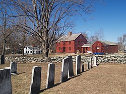
Arts and culture

Museums and other points of interest

West Boylston includes six entries on the National Register of Historic Places:

Government

County-level state agency heads
Clerk of Courts:Dennis P. McManus (D)
District Attorney:Joe Early Jr. (D)
Register of Deeds:Katie Toomey (D)
Register of Probate:Stephanie Fattman (R)
County Sheriff: Lew Evangelidis (R)
State government
State Representative(s): Jim O'Day (D)
State Senator(s):Robyn Kennedy (D-1st Worcester district)
Governor's Councilor(s):Paul DePalo (D)
Federal government
U.S. Representative(s): James P. McGovern (D-2nd District),
U.S. Senators: Elizabeth Warren (D), Ed Markey (D)

Education

West Boylston Middle/High School and Major Edwards Elementary School are located in the town.

Library

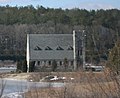
West Boylston's public library, the Beaman Memorial Public Library, was established in 1878. [7] [8] In fiscal year 2008, the town of West Boylston spent 1.6% ($308,576) of its budget on its public library—approximately $37 per person, per year ($48.76 adjusted for inflation to 2022). [9] The library building was listed on the National Register of Historic Places in 2016.

Media

The Banner newspaper covers current news about West Boylston; Coulter Press of Clinton, Massachusetts, publishes it. [10] [11] In the past, other newspapers have included the News Recorder and West Boylston Times. [12]

Notable people

Photos

Related Research Articles

<span class="mw-page-title-main">Berlin, Massachusetts</span> Town in Massachusetts, United States

Berlin is a town in Worcester County, Massachusetts, United States. The town was first settled in 1665 and incorporated in 1812, and is governed under the open town meeting system. It is located 12 miles (19 km) northeast of Worcester and 29 miles (47 km) west of Boston. The population was 3,158 at the 2020 census.

<span class="mw-page-title-main">Boylston, Massachusetts</span> Town in Massachusetts, United States

Boylston is a town in Worcester County, Massachusetts, United States. The population was 4,849 at the 2020 census.

<span class="mw-page-title-main">Gardner, Massachusetts</span> City in Massachusetts, United States

Gardner, officially the City of Gardner, is a city in Worcester County in the Commonwealth of Massachusetts, United States. The population was 21,287 in the 2020 census. Gardner is home of such sites as the Blue Moon Diner, Dunn State Park, Gardner Heritage State Park, and Mount Wachusett Community College.

<span class="mw-page-title-main">Hardwick, Massachusetts</span> Town in Massachusetts, United States

Hardwick is a town in Worcester County, Massachusetts, United States, about 20 miles (32 km) west of the city of Worcester. It had a population of 2,667 at the 2020 census. It includes the villages of Hardwick, Gilbertville, Wheelwright and Old Furnace.

<span class="mw-page-title-main">Holden, Massachusetts</span> Town in Massachusetts, United States

Holden is a town in Worcester County, Massachusetts, United States. The town was founded in 1741, and the Town Square was donated by John Hancock, former Governor of Massachusetts. The population was 19,905 at the 2020 census.

<span class="mw-page-title-main">Lancaster, Massachusetts</span> Town in Massachusetts, United States

Lancaster is a town in Worcester County, Massachusetts, in the United States. Incorporated in 1653, Lancaster is the oldest town in Worcester County. As of the 2020 census, the town population was 8,441.

<span class="mw-page-title-main">Paxton, Massachusetts</span> Town in Massachusetts, United States

Paxton is a town in Worcester County, Massachusetts, United States. The population was 5,004 at the 2020 census.

<span class="mw-page-title-main">Petersham, Massachusetts</span> Town in Massachusetts, United States

Petersham is a town in Worcester County, Massachusetts, United States. The population was 1,194 at the 2020 census. Petersham is home to a considerable amount of conservation land, including the Quabbin Reservation, Harvard Forest, the Swift River Reservation, and Federated Women's Club State Forest.

<span class="mw-page-title-main">Phillipston, Massachusetts</span> Town in Massachusetts, United States

Phillipston is a town in Worcester County, Massachusetts, United States. The population was 1,724 at the 2020 census.

<span class="mw-page-title-main">Princeton, Massachusetts</span> Town in Massachusetts, United States

Princeton is a town in Worcester County, Massachusetts, United States. It is bordered on the east by Sterling and Leominster, on the north by Westminster, on the northwest by Hubbardston, on the southwest by Rutland, and on the southeast by Holden. The preeminent landmark within Princeton is Mount Wachusett, which straddles the line between Princeton and Westminster but the entrance to which is within Princeton. According to tradition, in 1675, Mary Rowlandson was ransomed upon Redemption Rock, now within the town of Princeton, by King Philip. The population was 3,495 at the 2020 census. Princeton is a rural exurb, serving as a bedroom commuter town for nearby cities such as Worcester, Gardner, and Boston.

<span class="mw-page-title-main">Sterling, Massachusetts</span> Town in Massachusetts, United States

Sterling is a town in Worcester County, Massachusetts, in the United States. The population was 7,985 at the 2020 census.

<span class="mw-page-title-main">Westminster, Massachusetts</span> Town in Massachusetts, United States

Westminster is a town in Worcester County, Massachusetts, in the United States. At the 2020 census, the town population was 8,213.

<span class="mw-page-title-main">Clinton, Massachusetts</span> Town in Massachusetts, United States

Clinton is a town in Worcester County, Massachusetts, United States. The population was 15,428 at the 2020 census.

<span class="mw-page-title-main">Rutland, Massachusetts</span> Town in Massachusetts, United States

Rutland is a town in Worcester County, Massachusetts, United States. The population was 9,049 at the 2020 census. Rutland is the geographic center of Massachusetts; a tree, the Central Tree, located on Central Tree Road, marks the general spot.

<span class="mw-page-title-main">Nashua River</span> River in Massachusetts and New Hampshire, United States

The Nashua River, 37.5 miles (60.4 km) long, is a tributary of the Merrimack River in Massachusetts and New Hampshire in the United States. It is formed in eastern Worcester County, Massachusetts, at the confluence of the North Nashua River and South Nashua River, and flows generally north-northeast past Groton to join the Merrimack at Nashua, New Hampshire. The Nashua River watershed occupies a major portion of north-central Massachusetts and a much smaller portion of southern New Hampshire.

<span class="mw-page-title-main">Interstate 190 (Massachusetts)</span> Interstate Highway in Massachusetts

Interstate 190 (I-190) is a 19.26 miles (31.00 km) auxiliary Interstate Highway in the US state of Massachusetts, maintained by the Massachusetts Department of Transportation (MassDOT). Spanning approximately 19 miles (31 km) along a south–north axis, it is a spur route of I-90 in Central Massachusetts. However, its southern terminus exists at its split from I-290 in Worcester, which itself splits from the turnpike in Auburn. Its northern terminus lays at an interchange with Route 2 in Leominster.

<span class="mw-page-title-main">Wachusett Reservoir</span> Second largest body of water in the state of Massachusetts

The Wachusett Reservoir is the second largest body of water in the state of Massachusetts. It is located in central Massachusetts, northeast of Worcester. It is part of the water supply system for metropolitan Boston maintained by the Massachusetts Water Resources Authority (MWRA). It has an aggregate capacity of 65 billion US gallons (250,000,000 m3) and an area of almost 7 square miles (18 km2). Water from the reservoir flows to the covered Norumbega Storage Facility via the Cosgrove Tunnel and the MetroWest Water Supply Tunnel. The reservoir has a maximum depth of 120 feet (37 m) and a mean depth of 48 feet (15 m).

<span class="mw-page-title-main">Quinapoxet River</span> River

The Quinapoxet River is part of the Nashua River watershed in northern Massachusetts in the United States. It is part of the Massachusetts Water Resources Authority water system supplying drinking water to the greater Boston area.

<span class="mw-page-title-main">Stillwater River (Nashua River tributary)</span> River in the United States

The Stillwater River is part of the Nashua River watershed. This river is part of the Massachusetts Water Resources Authority system that supplies drinking water to the greater Boston area.

<span class="mw-page-title-main">Beaman Memorial Public Library</span> United States historic place

The Beaman Memorial Public Library is the public library of West Boylston, Massachusetts. It is located near the town common, at 8 Newton Street, in an architecturally distinguished Colonial Revival building constructed in 1912 to a design by Worcester architect Lucius Briggs. The building was listed on the National Register of Historic Places in 2016.

References

  1. "West Boylston, MA". West Boylston, MA. Retrieved October 4, 2012.
  2. "Census of Population and Housing". Census.gov. Retrieved June 4, 2016.
  3. "Census - Geography Profile: West Boylston town, Worcester County, Massachusetts". United States Census Bureau . Retrieved November 11, 2021.
  4. "City and Town Population Totals: 2020−2022". United States Census Bureau . Retrieved November 25, 2023.
  5. "U.S. Census website". United States Census Bureau . Retrieved January 31, 2008.
  6. U.S. Census Bureau. "2019 ACS 5-Year Estimates". data.census.gov. Retrieved April 29, 2021
  7. C.B. Tillinghast. The free public libraries of Massachusetts. 1st Report of the Free Public Library Commission of Massachusetts. Boston: Wright & Potter, 1891.
  8. Beaman Memorial Public Library. Retrieved November 10, 2010
  9. July 1, 2007 through June 30, 2008; cf. The FY2008 Municipal Pie: What’s Your Share? Commonwealth of Massachusetts, Board of Library Commissioners. Boston: 2009. Available: Municipal Pie Reports Archived January 23, 2012, at the Wayback Machine . Retrieved August 4, 2010
  10. "About Coulter Press". Worcester Telegram & Gazette Corp. Retrieved July 1, 2012.
  11. "Library Reference Resources: Newspapers". Beaman Memorial Public Library. Retrieved July 1, 2012.
  12. Boston Public Library, Microtext Department. "Massachusetts Newspapers". Newspapers on Microfilm. Retrieved May 13, 2012.