Linwood, Massachusetts

Last updated

Linwood
Linwood Mill 2005.jpg
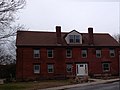
Historic Linwood Mill
USA Massachusetts location map.svg
Red pog.svg
Linwood
Location within the state of Massachusetts
Coordinates: 42°05′50″N71°38′41″W / 42.09722°N 71.64472°W / 42.09722; -71.64472
Country United States
State Massachusetts
County Worcester
Elevation
269 ft (82 m)
Time zone UTC-5 (Eastern (EST))
  Summer (DST) UTC-4 (EDT)
ZIP codes
01525
GNIS feature ID611020 [1]

Linwood is a village with its own post office in the towns of Northbridge and Uxbridge, Massachusetts, United States.

Contents

The zip code of the Linwood post office is 01525. As a village of both Uxbridge and Northbridge, [2] Linwood has separate municipal services from Uxbridge or Northbridge, for fire, police, EMS, School district, public works, and other services, depending on the town (township) boundary. Worcester County, Massachusetts Sheriff, Lewis Evangelidis runs corrections, and court services from West Boylston, and Worcester District is the regional judicial jurisdiction. The Uxbridge district court serves surrounding towns. Linwood is closest to the villages of Whitinsville, and North Uxbridge. The village of Linwood was predominantly settled by French Canadians, who historically worked in the local textile industry. [2] The Whitin Cotton Mills at Linwood were the principal industry and are a good example of the industrial architecture of the 19th century.

The Whitin Cotton Mill

The damming of the Mumford River in the early 19th century provided water power and led to the development of the Whitin Machine Works, the Cotton Mill and Linwood Mill. The mills also had access to a trunk line of the Providence and Worcester Railroad allowing easy transportation of goods into and out of the manufacturing facilities.

In 2011, the Linwood Mill was developed into 75 studio, one bedroom, and two bedroom units of 55+ ‘active adult’ senior rental residences. [3]

The ground floor of the Linwood Mill was developed into 22,000 square feet of commercial space including a restaurant, the Blackstone Valley Chamber of Commerce, office space, and a wine store.

James Whitin Linwood Cotton Mill, Linwood Ave in Northbridge Linwood Mill 2005.jpg
James Whitin Linwood Cotton Mill, Linwood Ave in Northbridge

Current businesses located in the Linwood Mill include the following:

National Register listings

The Butler Block in Linwood is listed on the National Historic Register, under Uxbridge, Massachusetts. The Linwood Cotton Mills are also listed on the National Historic Register. The Linwood Historic District includes late Victorian Structures, the Linwood Cotton Mills, and extends down Linwood Avenue to Pine and Maple. [4] The Blackstone Valley and Linwood are now part of the Blackstone River Valley National Heritage Corridor, the oldest industrialized region in the United States. The Blackstone Valley is New England's Historic National Park area. Built in 1866, the Linwood Mill was the crowning glory of James Fletcher Whitin and Charles Pinckney Whitin, sons of Colonel Paul and Betsy (Fletcher) Whitin. [5]

See also

Related Research Articles

<span class="mw-page-title-main">Northbridge, Massachusetts</span> Town in Massachusetts, United States

Northbridge is a town in Worcester County, Massachusetts, United States. The population was 16,335 at the 2020 census. The Northbridge Town Hall is located at 7 Main Street in Whitinsville. The town is now a part of the Blackstone River Valley National Heritage Corridor, of the National Park Service. Northbridge claims to history include: Native American Nipmuc lands, Colonel John Spring, who led the Uxbridge militia training company in the American Revolution, Samuel Spring, Revolutionary War Chaplain, the Residence of Ezra T. Benson 1830–1832, the birthplace of President Millard Fillmore's mother, Phoebe, and home to the Whitin Machine Works from 1831 to 1964.

<span class="mw-page-title-main">Uxbridge, Massachusetts</span> Town in Massachusetts, United States

Uxbridge is a town in Worcester County, Massachusetts, United States, first colonized in 1662 and incorporated in 1727. It was originally part of the town of Mendon, and named for the Earl of Uxbridge. The town is located 36 mi (58 km) southwest of Boston and 15 mi (24 km) south-southeast of Worcester, at the midpoint of the Blackstone Valley National Historic Park. The historical society notes that Uxbridge is the "Heart of The Blackstone Valley" and is also known as "the Cradle of the Industrial Revolution". Uxbridge was a prominent Textile center in the American Industrial Revolution. Two Quakers served as national leaders in the American anti-slavery movement. Uxbridge "weaves a tapestry of early America".

<span class="mw-page-title-main">Whitinsville, Massachusetts</span> Census-designated place in Massachusetts, United States

Whitinsville is an unincorporated village within the town of Northbridge in Worcester County, Massachusetts, United States. Whitinsville is a census-designated place (CDP) and its population was 6,750 at the 2020 census. Whitinsville is pronounced as if it were spelled "White-ins-ville". It was founded by the Whitin family, after whom it is also named. It is a post office jurisdiction, with a ZIP Code of 01588. It is located on the Mumford River, a tributary of the Blackstone River.

<span class="mw-page-title-main">Blackstone Valley</span> Region of Massachusetts & Rhode Island in the United States

The Blackstone Valley or Blackstone River Valley is a region of Massachusetts and Rhode Island. It was a major factor in the American Industrial Revolution. It makes up part of the Blackstone River Valley National Heritage Corridor and National Historical Park.

<span class="mw-page-title-main">Blackstone River Valley National Heritage Corridor</span> Area dedicated to the history of the early American Industrial Revolution

The John H. Chafee Blackstone River Valley National Heritage Corridor is a National Heritage Corridor dedicated to the history of the early American Industrial Revolution, including mill towns stretching across 25 cities and towns near the river's course in Worcester County, Massachusetts, and Providence County, Rhode Island. It makes up a historical area in the Blackstone Valley and is named for the late US Senator from Rhode Island John Chafee. In 2014, the Blackstone River Valley National Historical Park was created out of a smaller portion of the National Heritage Corridor. The two units now exist as cooperative entities. The organization is headquartered at the building in Whitinsville, MA, which is located at 670 Linwood Ave, Whitinsville, MA 01588.

<span class="mw-page-title-main">Mumford River</span>

The Mumford River is an 18.3-mile-long (29.5 km) river in south-central Massachusetts. It is a tributary of the Blackstone River.

<span class="mw-page-title-main">Robert Rogerson</span> American businessman

Robert Rogerson was an early American industrialist. He was born in Taunton, Massachusetts, and died in the United States.

<span class="mw-page-title-main">Paul Whitin</span>

Col. Paul Whitin, (1767–1831) was an American blacksmith and pioneering industrialist who in 1826 Northbridge, Massachusetts established P Whitin and Sons, a new cotton mill with his sons. This company would grow and acquire other mills in the area. In 1831 his son John C Whitin obtained a patent for a mechanized Cotton Picker. Textile machinery would become a larger percentage of their business over time. would later become the largest maker of specialty textile machinery in the world.

<span class="mw-page-title-main">Blackstone River and Canal Heritage State Park</span>

The Blackstone River and Canal Heritage State Park is a part of the state park system of the Commonwealth of Massachusetts, managed by the Massachusetts Department of Conservation and Recreation (DCR). This 1,000-acre (4.0 km2) park "recalls the role of canals in transporting raw materials and manufactured goods between emerging industrial centers." The Blackstone River and Canal Heritage State Park at Uxbridge, Massachusetts, is the midpoint of the Blackstone River Valley National Heritage Corridor of the National Park System. The Blackstone River and Valley is where the industrial revolution was born in America. The southern entrance to this state park is the site of the historic Stanley Woolen Mill, currently being redeveloped for commercial and tourism. The Native American Nipmuc name for the village here was "Wacentug", translated as "bend in the river".

<span class="mw-page-title-main">North Uxbridge, Massachusetts</span> Village in Massachusetts, United States

North Uxbridge is a village and a post office in the town (township) of Uxbridge in Worcester County, Massachusetts, United States. The postal zip code is 01538. It is classified as a community or populated place located at latitude 42.088 and longitude -71.641 and the elevation is 266 feet (81 m). North Uxbridge appears on the Uxbridge U.S. Geological Survey Map. Worcester County is in the Eastern time zone and observes DST. North Uxbridge is located approximately 36 miles west-southwest of Boston, and 15 miles southeast of Worcester. The town meeting in 1885 set aside North Uxbridge as a "special district", since its population had exceeded 1000 people. North Uxbridge appeared as a separate Census tract in the 1960 census, with a population of 1882. In 2013, an Uxbridge DIY show, The Garage, with Steve Butler, went worldwide from Steve's garage in North Uxbridge.

<span class="mw-page-title-main">Wheelockville, Massachusetts</span> Village in Massachusetts, United States

Wheelockville is a village in the town (township) of Uxbridge, Massachusetts, United States. Part of the village centering on Mendon and Henry streets is listed on the National Register of Historic Places as the Wheelockville Historic District. Wheelockville appears on the Blackstone U.S. Geological Survey Map. The Village receives municipal services from Uxbridge, for fire, police, EMS, School district, public works, and other services. Worcester's Judicial District includes Uxbridge District Court. The geography of Wheelockville includes several other distinct mill villages, including: Hecla and Elmdale.

<span class="mw-page-title-main">Rogerson's Village Historic District</span> Historic district in Massachusetts, United States

Rogersons Village Historic District is a historic mill village in Uxbridge, Massachusetts, United States.

<span class="mw-page-title-main">West Hill Dam</span> Flood control impoundment in the U.S. state of Massachusetts

West Hill Dam Reserve is a United States Army Corps of Engineers flood control project with a recreational park and wildlife management area located at Uxbridge, Massachusetts. The West Hill Dam Project was completed in June 1961. It is located on the West River, one of the branches of the Blackstone River which flows from Worcester, MA to Providence, RI. The West River originates in Grafton, Massachusetts, at Cider Mill Pond and Silver Lake, near Upton, Massachusetts, and the Upton State Forest. The dam is unusual in that it isn't filled unless there is a flood. West Hill Dam was built after devastating floods during the 1950s; it is intended to protect the Blackstone Valley from future destructive flooding. The cities and towns downriver from Uxbridge, including Millville, Blackstone, Woonsocket, North Smithfield, Cumberland, Lincoln, Central Falls, Pawtucket and Providence, Rhode Island, suffered extensive flooding from the Blackstone during Hurricane Diane in 1955. Hurricane Donna tested this new dam in 1960 as the eyewall passed over. The West Hill Dam is located in the Blackstone River Valley National Heritage Corridor near the Blackstone River and Canal Heritage State Park. Park rangers provide visitor assistance and offer scheduled interpretative programs. Fishing, hunting, and wildlife viewing opportunities are available year-round. The park has a recreation area, 34 picnic sites, one playground, a swimming area and five miles of hiking trails. However, access to the park from West Hill Road is currently blocked as of 2021 because of landowner disagreements. West Hill Dam is also the field office for the Charles River Natural Valley Storage Area. It consists of scattered wetlands in the upper and middle Charles River watershed, between the towns of Bellingham and Needham. The wetlands provide flood storage area, fisheries, wildlife management, and recreation. The Charles River is the well-known watercourse that flows into Boston Harbor.

The Taft family is an American political family of English and Irish descent, with origins in Massachusetts. Its members have served in the states of Massachusetts, Ohio, Rhode Island, Utah, and Vermont, and the United States federal government, in various positions such as representative (two), governor of Ohio, governor of Rhode Island, senator (three), secretary of agriculture, attorney general, secretary of war (two), acting secretary of defense, president, and chief justice.

<span class="mw-page-title-main">Linwood Historic District (Northbridge, Massachusetts)</span> Historic district in Massachusetts, United States

The Linwood Historic District is an industrial historic district in the Linwood village of Northbridge, Massachusetts. It is the site of the Linwood Cotton Mill and is roughly bounded by Linwood Avenue, Maple Court, and Pine Court. On June 16, 1989, it was added to the National Register of Historic Places.

<span class="mw-page-title-main">Whitin Machine Works</span> Textile machinery company in Massachusetts

The Whitin Machine Works (WMW) was founded by Paul Whitin and his sons in 1831 on the banks of the Mumford River in Northbridge, Massachusetts. The village in this section of Northbridge became known as Whitinsville in 1835, in honor of its founder.

<span class="mw-page-title-main">Rockdale Common Housing District</span> Historic district in Massachusetts, United States

The Rockdale Common Housing District is a historic district at 4–20 McBride, 46–58 Plantation, and 37–42 Taft Sts. in Northbridge, Massachusetts, United States. The district is composed of a collection of tenement houses built from c. 1880 to 1920. They were built by members of the Whitin family, who owned most of the textile production capacity in Northbridge. The district was added to the National Register of Historic Places in 1983.

<span class="mw-page-title-main">Whitinsville Historic District</span> Historic district in Massachusetts, United States

The Whitinsville Historic District is a historic district on Church, East, Fletcher, Hill, Woodland, Lake, and Water Sts., Castle Hill Rs., and Linwood Avenue in Northbridge, Massachusetts. The district encompasses the historic 19th century mill village of Whitinsville, which grew up around an 1826 brick mill building erected by Paul Whitin. The Whitin family came to dominate the textile trade in Northbridge, with numerous mill complexes.

The history of Uxbridge, Massachusetts, founded in 1727, may be divided into its prehistory, its colonial history and its modern industrial history. Uxbridge is located on the Massachusetts-Rhode Island state line, and became a center of the earliest industrialized region in the United States.

References

  1. "Linwood, Massachusetts". Geographic Names Information System . United States Geological Survey, United States Department of the Interior . Retrieved September 1, 2011.
  2. 1 2 "Walking tours - Uxbridge". Blackstone Daily. Archived from the original on September 28, 2007. Retrieved September 23, 2007.{{cite web}}: CS1 maint: unfit URL (link)
  3. "Linwood Mill Apartments".
  4. "National Register Information System". National Register of Historic Places . National Park Service. January 23, 2007.
  5. page 9, Blackstonevalleytribune, 12/21/07.