Blackstone River Valley National Historical Park

Last updated

Blackstone River Valley National Historical Park
LincolnRI OldAshton KelleyHouse BlackstoneCanal.jpg
Blackstone Canal
USA Rhode Island relief location map.svg
Red pog.svg
Relief map of USA Massachusetts.png
Red pog.svg
Usa edcp relief location map.png
Red pog.svg
Location Providence County, Rhode Island/Worcester County, Massachusetts, United States
Nearest city Pawtucket, Rhode Island
Coordinates 41°52′39″N71°22′57″W / 41.87750°N 71.38250°W / 41.87750; -71.38250
CreatedDecember 19, 2014 (2014-December-19)
Governing body National Park Service, State, Private
Website Blackstone River Valley National Historical Park

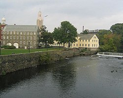
Blackstone River Valley National Historical Park is a National Park Service unit in the states of Rhode Island and Massachusetts. The park was created for the purpose of preserving, protecting, and interpreting the industrial heritage of the Blackstone River Valley and the urban, rural, and agricultural landscape of that region. The Blackstone River Valley was the site of some of the earliest successful textile mills in the United States, and these mills contributed significantly to the earliest American Industrial Revolution. The subsequent construction of the Blackstone Canal, a few years after the successful completion of the Erie Canal, helped to sustain the region's industrial strength.

Contents

The park's establishment was included as part of the National Defense Authorization Act for Fiscal Year 2015, which was signed into law by President Barack Obama on December 19, 2014. [1] [2]

It is closely related to the Blackstone River Valley National Heritage Corridor, which is not a unit of the National Park System, but the National Historical Park contains only a subset of the sites associated with that National Heritage Area. The Blackstone River Valley National Heritage Corridor continues to exist independently of the National Historical Park.

Background

Samuel Slater, an English industrialist, constructed his first textile mill in Pawtucket, in 1793, along the Blackstone River. In addition to utilizing advanced new technology he had learned about in England, which had previously never been used in an American mill, Slater implemented an innovative management style that helped his factory find significant success. He went on to establish other factories, including the company towns like the village of Slatersville in North Smithfield, Rhode Island. The textile industry continued to expand in the Blackstone region, spawning numerous mill towns. By the late 1820s, the industry was thriving to such an extent that more efficient transportation methods were needed, which led to the construction of the Blackstone Canal connecting Worcester, Massachusetts to the sea port at Providence, Rhode Island. The region's advances were an important component in American industrial history.

This history was deemed nationally significant by Congress in 1986 when it created the Blackstone River Valley National Heritage Corridor, a collaboration between the National Park Service, state and local governments, and non-profit entities to encourage preservation and tourism in the region. In looking for ways to enhance achieving those goals, Congress requested that the National Park Service conduct a special resource study to determine if certain sites in the region should be included as a formal unit of the National Park System. This study was completed in 2011, and recommended the creation of a National Historical Park, which was then established in 2014. [1] [3]

Park sites

Slater Mill SlaterMill.JPG
Slater Mill

Based on its establishment legislation, the park encompasses the following sites: [4]

Related Research Articles

<span class="mw-page-title-main">Uxbridge, Massachusetts</span> Town in Massachusetts, United States

Uxbridge is a town in Worcester County, Massachusetts, United States,A first colonized in 1662 and incorporated in 1727. It was originally part of the town of Mendon, and named for the Earl of Uxbridge. The town is located 36 mi (58 km) southwest of Boston and 15 mi (24 km) south-southeast of Worcester, at the midpoint of the Blackstone Valley National Historic Park. The historical society notes that Uxbridge is the "Heart of The Blackstone Valley" and is also known as "the Cradle of the Industrial Revolution". Uxbridge was a prominent Textile center in the American Industrial Revolution. Two Quakers served as national leaders in the American anti-slavery movement. Uxbridge "weaves a tapestry of early America".

<span class="mw-page-title-main">North Smithfield, Rhode Island</span> Town in Rhode Island, United States

North Smithfield is a town in Providence County, Rhode Island, United States, settled as a farming community in 1666 and incorporated into its present form in 1871. North Smithfield includes the historic villages of Forestdale, Primrose, Waterford, Branch Village, Union Village, Park Square, and Slatersville. The population was 12,588 at the 2020 census.

<span class="mw-page-title-main">Pawtucket, Rhode Island</span> City in Rhode Island

Pawtucket is a city in Providence County, Rhode Island. The population was 75,604 at the 2020 census, making the city the fourth-largest in the state. Pawtucket borders Providence and East Providence to the south, Central Falls and Lincoln to the north, and North Providence to the west. The city also borders the Massachusetts municipalities of Seekonk and Attleboro.

<span class="mw-page-title-main">Samuel Slater</span> English-American industrialist

Samuel Slater was an early English-American industrialist known as the "Father of the American Industrial Revolution", a phrase coined by Andrew Jackson, and the "Father of the American Factory System". In the United Kingdom, he was called "Slater the Traitor" and "Sam the Slate" because he brought British textile technology to the United States, modifying it for American use. He stole the textile factory machinery designs as an apprentice to a pioneer in the British industry before migrating to the U.S. at the age of 21.

<span class="mw-page-title-main">Blackstone River</span> River in Massachusetts and Rhode Island, USA

The Blackstone River is a river in the U.S. states of Massachusetts and Rhode Island. It flows approximately 48 mi (80 km) and drains a watershed of approximately 540 sq. mi (1,400 km2). Its long history of industrial use has left a legacy of pollution, and it was characterized by the United States Environmental Protection Agency in 1990 as "the most polluted river in the country concerning toxic sediments."

<span class="mw-page-title-main">Blackstone Valley</span> Region of Massachusetts & Rhode Island in the United States

The Blackstone Valley or Blackstone River Valley is a region of Massachusetts and Rhode Island. It was a major factor in the American Industrial Revolution. It makes up part of the Blackstone River Valley National Heritage Corridor and National Historical Park.

<span class="mw-page-title-main">Blackstone Canal</span> United States historic place

The Blackstone Canal was a waterway linking Worcester, Massachusetts, to Providence, Rhode Island through the Blackstone Valley via a series of locks and canals during the early 19th century. Construction was started in 1825, and the canal opened three years later. Following the opening of the Boston and Providence Railroad in 1835, the canal struggled for business. It was ultimately replaced by the Providence and Worcester Railroad, which completed a parallel line using much of the canal right-of-way in 1847, the canal shut down in 1848. Several segments of the canal are preserved.

<span class="mw-page-title-main">Slater Mill Historic Site</span> United States historic place

The Slater Mill is a historic water-powered textile mill complex on the banks of the Blackstone River in Pawtucket, Rhode Island, modeled after cotton spinning mills first established in England. It is the first water-powered cotton spinning mill in America to utilize the Arkwright system of cotton spinning as developed by Richard Arkwright.

<span class="mw-page-title-main">Blackstone River Valley National Heritage Corridor</span> Area dedicated to the history of the early American Industrial Revolution

The John H. Chafee Blackstone River Valley National Heritage Corridor is a National Heritage Corridor dedicated to the history of the early American Industrial Revolution, including mill towns stretching across 25 cities and towns near the river's course in Worcester County, Massachusetts, and Providence County, Rhode Island. It makes up a historical area in the Blackstone Valley and is named for the late US Senator from Rhode Island John Chafee. In 2014, the Blackstone River Valley National Historical Park was created out of a smaller portion of the National Heritage Corridor. The two units now exist as cooperative entities. The organization is headquartered at the building in Whitinsville, MA, which is located at 670 Linwood Ave, Whitinsville, MA 01588.

<span class="mw-page-title-main">Slatersville, Rhode Island</span> United States historic place

Slatersville is a village on the Branch River in the town of North Smithfield, Rhode Island, United States. It includes the Slatersville Historic District, a historic district listed on the National Register of Historic Places. The historic district has been included as part of the Blackstone River Valley National Historical Park. The North Smithfield Public Library is located in Slatersville.

<span class="mw-page-title-main">Blackstone River and Canal Heritage State Park</span>

The Blackstone River and Canal Heritage State Park is a part of the state park system of the Commonwealth of Massachusetts, managed by the Massachusetts Department of Conservation and Recreation (DCR). This 1,000-acre (4.0 km2) park "recalls the role of canals in transporting raw materials and manufactured goods between emerging industrial centers." The Blackstone River and Canal Heritage State Park at Uxbridge, Massachusetts, is the midpoint of the Blackstone River Valley National Heritage Corridor of the National Park System. The Blackstone River and Valley is where the industrial revolution was born in America. The southern entrance to this state park is the site of the historic Stanley Woolen Mill, currently being redeveloped for commercial and tourism. The Native American Nipmuc name for the village here was "Wacentug", translated as "bend in the river".

<span class="mw-page-title-main">Wheelockville, Massachusetts</span> Village in Massachusetts, United States

Wheelockville is a village in the town (township) of Uxbridge, Massachusetts, United States. Part of the village centering on Mendon and Henry streets is listed on the National Register of Historic Places as the Wheelockville Historic District. Wheelockville appears on the Blackstone U.S. Geological Survey Map. The Village receives municipal services from Uxbridge, for fire, police, EMS, School district, public works, and other services. Worcester's Judicial District includes Uxbridge District Court. The geography of Wheelockville includes several other distinct mill villages, including: Hecla and Elmdale.

<span class="mw-page-title-main">Ironstone, Massachusetts</span> Village in Massachusetts, United States

Ironstone is an historic village,, in the township of Uxbridge, Massachusetts, United States. It derived its name from plentiful bog iron found here which helped Uxbridge to become a center for three iron forges in the town's earliest settlement. South Uxbridge has historic sites, picturesque weddings, hospitality, industrial and distribution centers, and the new Uxbridge High School. This community borders North Smithfield, and Burrillville, Rhode Island, and Millville, Massachusetts. South Uxbridge receives municipal services from Uxbridge, for fire, police, EMS, School district, public works, and other services. There is a South Uxbridge fire station of the Uxbridge fire department. Worcester's Judicial District includes Uxbridge District Court. Ironstone appears on the Blackstone U.S. Geological Survey Map. Worcester County is in the Eastern time zone and observes DST.

<span class="mw-page-title-main">West Hill Dam</span>

West Hill Dam Reserve is a United States Army Corps of Engineers flood control project with a recreational park and wildlife management area located at Uxbridge, Massachusetts. The West Hill Dam Project was completed in June 1961. It is located on the West River, one of the branches of the Blackstone River which flows from Worcester, MA to Providence, RI. The West River originates in Grafton, Massachusetts, at Cider Mill Pond and Silver Lake, near Upton, Massachusetts, and the Upton State Forest. The dam is unusual in that it isn't filled unless there is a flood. West Hill Dam was built after devastating floods during the 1950s; it is intended to protect the Blackstone Valley from future destructive flooding. The cities and towns downriver from Uxbridge, including Millville, Blackstone, Woonsocket, North Smithfield, Cumberland, Lincoln, Central Falls, Pawtucket and Providence, Rhode Island, suffered extensive flooding from the Blackstone during Hurricane Diane in 1955. Hurricane Donna tested this new dam in 1960 as the eyewall passed over. The West Hill Dam is located in the Blackstone River Valley National Heritage Corridor near the Blackstone River and Canal Heritage State Park. Park rangers provide visitor assistance and offer scheduled interpretative programs. Fishing, hunting, and wildlife viewing opportunities are available year-round. The park has a recreation area, 34 picnic sites, one playground, a swimming area and five miles of hiking trails. However, access to the park from West Hill Road is currently blocked as of 2021 because of landowner disagreements. West Hill Dam is also the field office for the Charles River Natural Valley Storage Area. It consists of scattered wetlands in the upper and middle Charles River watershed, between the towns of Bellingham and Needham. The wetlands provide flood storage area, fisheries, wildlife management, and recreation. The Charles River is the well-known watercourse that flows into Boston Harbor.

<span class="mw-page-title-main">Old Ashton Historic District</span> Historic district in Rhode Island, United States

The Old Ashton Historic District is a historic district encompassing an early 18th-century industrial area along Lower River Road in Lincoln, Rhode Island. It includes the site of the first textile mill in Lincoln, which was established in 1810–15, and whose original mill building no longer survives. The proprietors of the mill built a series of modest worker houses on Lower River Road, which are now separated from the mill site by a section of the Blackstone Canal. The only structure near the mill site is the Kelly House, built in the 1820s by Wilbur Kelly, one of the mill owners. The area is now a stopping point in Blackstone River Bikeway State Park, with interpretive signs explaining the area's history.

<span class="mw-page-title-main">Blackstone Manufacturing Company Historic District</span> Historic district in Massachusetts, United States

The Blackstone Manufacturing Company Historic District encompasses the "New City" or "High Rocks" area of Blackstone, Massachusetts, an industrial village associated with the Blackstone Manufacturing Company, which began operations in 1809. It includes an area roughly surrounding Butler, Canal, Church, County, Ives, Main, Mendon, Old Mendon, and School Streets. The district includes a wide variety of worker housing, as well as a granite storehouse, the only surviving company structure. The district was added to the National Register of Historic Places in 1995.

<span class="mw-page-title-main">Valley Falls Company</span>

The Valley Falls Company was founded in 1839 by Oliver Chace, in Valley Falls, Rhode Island, a historic mill village on both sides of the Blackstone River, within the modern-day town of Cumberland and city of Central Falls, Rhode Island. The Valley Falls Company is the original antecedent of Berkshire Hathaway, currently one of the world's largest and most successful companies.

<span class="mw-page-title-main">Mill conversion</span>

Mill Conversion or mill rehab is a form of adaptive reuse in which a historic mill or industrial factory building is restored or rehabilitated into another use, such as residential housing, retail shops, office, or a mix of these non-industrial elements (mixed-use).

<span class="mw-page-title-main">Stanley Woolen Mill</span>

Stanley Woolen Mill is the common historic name applied to a defunct company based in southeastern Massachusetts and to the company's buildings which stand at the southern entrance to the Blackstone River and Canal Heritage State Park. The mill is an important footnote in the history of the textile industry in America. Stanley Woolen Mill is the centerpiece of the Central Woolen Mills District which is part of the National Historic Register.

The Rhode Island System refers to a system of mills, complete with small villages and farms, ponds, dams, and spillways first developed by Samuel Slater and his brother John Slater.

References

  1. 1 2 "Congress approves creation of Blackstone River Valley National Historical Park". December 15, 2014. Retrieved April 6, 2015.
  2. "The National Defense Authorization Act and Public Lands" . Retrieved April 6, 2015.
  3. "Blackstone River Valley Special Resource Study" . Retrieved April 6, 2015.
  4. "Blackstone River Valley National Historical Park" . Retrieved April 6, 2015.
  5. "Blackstone River State Park" . Retrieved April 6, 2015.
  6. "The Captain Wilbur Kelly House" . Retrieved April 6, 2015.