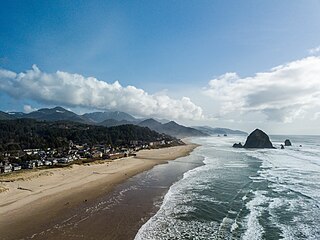
Cannon Beach is a city in Clatsop County, Oregon, United States. Its population was 1,690 at the 2010 census. It is a popular coastal Oregon tourist destination, famous for Haystack Rock, a 235 ft (72 m) sea stack that juts out along the coast. In 2013, National Geographic listed it as "one of the world's 100 most beautiful places."

The Oregon Coast is a coastal region of the U.S. state of Oregon. It is bordered by the Pacific Ocean to its west and the Oregon Coast Range to the east, and stretches approximately 362 miles (583 km) from the California state border in the south to the Columbia River in the north. The region is not a specific geological, environmental, or political entity, and includes the Columbia River Estuary.

Fort Clatsop was the encampment of the Lewis and Clark Expedition in the Oregon Country near the mouth of the Columbia River during the winter of 1805–1806. Located along the Lewis and Clark River at the north end of the Clatsop Plains approximately 5 miles (8.0 km) southwest of Astoria, the fort was the last encampment of the Corps of Discovery, before embarking on their return trip east to St. Louis.

The Clatsop are a Chinookan-speaking Indigenous people of the Pacific Northwest of the United States. In the early 19th century they inhabited an area of the northwestern coast of present-day Oregon from the mouth of the Columbia River south to Tillamook Head, Oregon. Today, Clatsop descendants are members of the federally recognized Confederated Tribes of Siletz Indians, as well as the unrecognized Chinook Indian Nation and Clatsop-Nehalem Confederated Tribes.
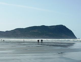
Tillamook Head is a high promontory on the Pacific coast of northwest Oregon in the United States. It is located in west-central Clatsop County, approximately 5 mi (8 km) southwest of Seaside. The promontory forms a steep rocky bluff on the ocean, approximately 1,200 ft high, forested with Sitka spruce. It is located in Ecola State Park.

Fort Stevens was an American military installation that guarded the mouth of the Columbia River in the state of Oregon. Built near the end of the American Civil War, it was named for Civil War general and former Washington Territory governor, Isaac I. Stevens. The fort was an active military reservation from 1863–1947. It is now listed on the National Register of Historic Places.

The Columbia Bar is a system of bars and shoals at the mouth of the Columbia River spanning the U.S. states of Oregon and Washington. It is one of the most dangerous bar crossings in the world, earning the nickname Graveyard of the Pacific. The bar is about 3 miles (5 km) wide and 6 miles (10 km) long.
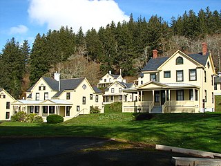
Fort Columbia State Park is a public recreation area and historic preserve at the site of the former Fort Columbia, located on Chinook Point at the mouth of the Columbia River in Chinook, Washington. The 618-acre (250 ha) state park features twelve historic wood-frame buildings from the fort complex as well as an interpretive center and hiking trails. The park's grounds are located over a tunneled section of U.S. Route 101.

The Lewis and Clark National Historic Trail is a route across the United States commemorating the Lewis and Clark Expedition of 1804 to 1806. It is part of the National Trails System of the United States. It extends for some 4,900 miles (7,900 km) from Pittsburgh, Pennsylvania, to the mouth of the Columbia River in Oregon.
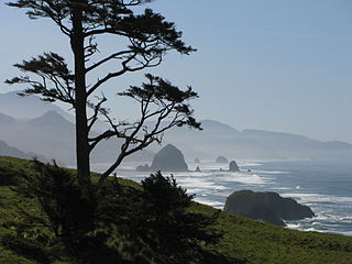
Ecola State Park is a state park located approximately 3 miles (4.8 km) north of Cannon Beach in Clatsop County in the U.S. state of Oregon on the Oregon Coast. It is administered by the Oregon Parks and Recreation Department.

Cape Disappointment State Park is a public recreation area on Cape Disappointment, located southwest of Ilwaco, Washington, on the bottom end of Long Beach Peninsula, the northern headlands where the Columbia River meets the Pacific Ocean. The state park's 2,023 acres (819 ha) encompass a diverse landscape of old-growth forest, freshwater lakes, freshwater and saltwater marshes, and oceanside tidelands. Park sites include Fort Canby, the Lewis and Clark Interpretive Center, North Head Lighthouse, and Cape Disappointment Lighthouse. Cape Disappointment is one of several state parks and sites in Washington and Oregon that are included in Lewis and Clark National Historical Park.
Sunset Beach is a small unincorporated community located between the cities of Seaside and Warrenton in Clatsop County, Oregon, United States. Sunset Beach is located between U.S. Route 101, Sunset Lake and the Pacific Ocean. It serves as the northernmost access to the resort community of Surf Pines, and provides motor vehicle beach access. The "Fort to Sea Trail", which follows the route used by the Lewis and Clark Expedition when hiking from Fort Clatsop to the Pacific Ocean, ends at the beach access. A beach of the same name is west of the community.

Saddle Mountain is the tallest mountain in Clatsop County in the U.S. state of Oregon. Part of the Oregon Coast Range, Saddle Mountain is in Saddle Mountain State Natural Area in the northwest corner of Oregon. The peak is listed on Oregon's Register of Natural Heritage Resources.
State Route 100 (SR 100) is a 4.68-mile-long (7.53 km) state highway in the U.S. state of Washington, serving Cape Disappointment State Park in Pacific County. The highway travels counterclockwise from U.S. Route 101 (US 101) in Ilwaco south to Cape Disappointment and north to an intersection with itself in Ilwaco. SR 100, part of the Lewis and Clark Trail Scenic Byway, serves as a loop route and has a spur route that serves the state park and a Coast Guard station. SR 100 was established in 1991 on the existing North Head Road, which was a paved county road by the late 1950s. The highway was washed away during a 1994 winter storm and had its spur route shortened in 2006.

Cape Disappointment is a headland of the Pacific Northwest, located at the extreme southwestern corner of Washington, United States, on the north side of the Columbia River bar and just west of Baker Bay. The point of the cape is located on the Pacific Ocean in Washington's Pacific County, approximately two miles (3.2 km) southwest of the town of Ilwaco. Cape Disappointment sees about 2,552 hours of fog a year—the equivalent of 106 days—making it one of the foggiest places in the U.S.

Sunset Beach State Recreation Site is a state park in Clatsop County, Oregon, United States, administered by the Oregon Parks and Recreation Department. The park comprises 120 acres (49 ha) along the Pacific Ocean on the Clatsop Plains.

Arch Cape is an unincorporated community in Clatsop County, Oregon, United States. Named for the natural arch in the coastal rocks and the headland (cape) that extends into the Pacific Ocean, it is located along the Pacific coast, approximately four miles south of Cannon Beach, between Hug Point State Recreation Site to the north and Oswald West State Park to the south.
Dismal Nitch is the name of a cove along the lower Columbia River in Washington state, notable as the Lewis and Clark Expedition's last campsite before sighting the Pacific Ocean.

Northwest Oregon is a geographic and cultural region of the U.S. state of Oregon, composed of Clatsop, Columbia, and Tillamook counties. The region encompasses the northernmost parts of the state along the lower Columbia River.


