
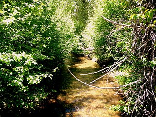
Silver Falls State Park is a state park in the U.S. state of Oregon, located near Silverton, about 20 miles (32 km) east-southeast of Salem. It is the largest state park in Oregon with an area of more than 9,000 acres (36 km2), and it includes more than 24 miles (39 km) of walking trails, 14 miles (23 km) of horse trails, and a 4-mile (6.4 km) bike path. Its 8.7-mile (14.0 km) Canyon Trail/Trail of Ten Falls runs along the banks of Silver Creek and by ten waterfalls, from which the park received its name. Four of the ten falls have an amphitheater-like surrounding that allows the trail to pass behind the flow of the falls. The Silver Falls State Park Concession Building Area and the Silver Creek Youth Camp-Silver Falls State Park are separately listed on the U.S. National Register of Historic Places.

Joseph H. Stewart State Recreation Area is a state park located on the Rogue River approximately 40 miles (64 km) from Crater Lake National Park and 35 miles (56 km) northeast of Medford in Jackson County, southern Oregon. It is administered by the Oregon Parks and Recreation Department. Campsites are provided overlooking the Lost Creek Reservoir.

Bald Peak State Scenic Viewpoint is a state park located atop Bald Peak located in Yamhill County, in the United States. The day use only park offers picnic tables and a hiking trail for views of the Willamette Valley and the Cascade Range. The state of Oregon acquired the 26 acres (11 ha) in 1931 after Yamhill and Washington counties requested a park from the state.

Tumalo State Park is a well-developed state park in Deschutes County, Oregon, United States. Established in 1954, the park is located northwest of the city of Bend and along the Deschutes River at a site home to many bird species. The park is popular for picnics, swimming, fishing, hiking, and camping, and is open year-round.

Chandler State Wayside is a state park in south-central Oregon in the United States. It is named in honor of Solomon and Hattie Chandler, who donated the land for the park. The park covers 85 acres (34 ha) of pine forest along a creek. The park provides restrooms and other basic facilities to accommodate the traveling public. Chandler State Wayside is administered by the Oregon Parks and Recreation Department.
Sun Pass State Forest is one of six state forests managed by the Oregon Department of Forestry. The forest is located 40 miles (64 km) north of Klamath Falls, Oregon near the southeastern corner of Crater Lake National Park. It is the largest single block of Oregon state forestry land east of the Cascade Mountains. The forest is managed as part of the Klamath-Lake District, comprising 21,317 acres (86.27 km2) of the 33,739 state-owned acres within the district.

Santiam State Forest is one of six state forests managed by the Oregon Department of Forestry. The forest is located approximately 25 miles (40 km) southeast of Salem, Oregon, and includes 47,871 acres (193.73 km2) on the western slope of the Cascade Mountains in three Oregon counties: Clackamas, Linn, and Marion. It is bounded on the east by the Willamette National Forest and Mount Hood National Forest. Silver Falls State Park is located west of the forest. The rest of the land surrounding the forest belongs to the Bureau of Land Management or is privately owned. The forest is managed as part of the Department of Forestry's North Cascade District.

Goose Lake State Recreation Area is located on Stateline Road, between New Pine Creek, Oregon and Goose Lake in Lake County, Oregon, on the east side of Goose Lake on the Oregon–California border.

Samuel H. Boardman State Scenic Corridor is a linear state park in southwestern Oregon, in the United States. It is 12 miles (19 km) long and thickly forested along steep and rugged coastline with a few small sand beaches. It is named in honor of Samuel H. Boardman, the first Oregon Parks superintendent.

H. B. Van Duzer Forest State Scenic Corridor is a 12-mile (19 km) scenic driving route along Route 18 in Lincoln, Tillamook, and Polk counties in the U.S. state of Oregon that passes through a forested corridor. The Van Duzer Corridor stretches from northwestern Polk County to Lincoln City, passing through the Northern Oregon Coast Range.
Bullards Beach State Park is a state park in the U.S. state of Oregon, administered by the Oregon Parks and Recreation Department.

Cascadia State Park is a state park in the U.S. state of Oregon near Sweet Home along the South Santiam River at Cascadia. The park includes a day use area, campsites, hiking trails and 150 foot Lower Soda Creek Falls.

Ellmaker State Wayside is a state park in the U.S. state of Oregon, administered by the Oregon Parks and Recreation Department. It is located on U.S. Route 20 approximately 1 mile (1.6 km) north of the community of Burnt Woods.
Fall Creek State Recreation Site is a state park in the U.S. state of Oregon, administered by the Oregon Parks and Recreation Department. The park includes 47 campsites that do not include many luxuries. Each site includes a picnic table and a fire ring. There is also a designated swimming area in the lake that Fall Creek flows into. A dock and boat ramp are on the lake as well.

Rocky Creek State Scenic Viewpoint is a state park in Lincoln County in northwestern Oregon, United States. Administered by the Oregon Parks and Recreation Department, the 59-acre (24 ha) park lies along a bluff between Whale Cove and Rocky Creek. The park extends south along the Otter Crest Loop Road to the Rocky Creek Bridge.

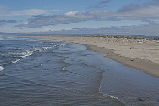
Sunset Bay State Park is a state park in the U.S. state of Oregon. Administered by the Oregon Parks and Recreation Department, it is about 0.4 miles (0.6 km) south of Cape Arago Lighthouse and 2.5 miles (4.0 km) outside the town of Charleston on Coos Bay. The park offers a crescent shaped beach, tide pools, hiking trails and a year-round campground.
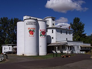
Thompson's Mills State Heritage Site is a state park near Shedd in Linn County, Oregon, United States, administered by the Oregon Parks and Recreation Department. The mill was first built in 1858. It burned down in 1862, but was rebuilt right away and the 12 inch by 12 inch hand hewn beams cut and placed while Lincoln was in office are still visible inside the mill today. A series owners adapted the mill to changing times turning the flour mill to a feed mill and eventually a hydroelectric plant operating until 2004, making it one of Oregon's oldest continuously operating water-powered businesses. Oregon State Parks purchased the property in 2004 and the park was opened to the public in December, 2007. The property was acquired and restored under governor Kulongoski's "park-a-year" plan, in which one new state park is to be opened every year. Free guided tours are offered daily allowing visitors to see the water powered turbines and machinery in action. The grounds are being restored to the 1910-1930s era with the heirloom orchard, gardens and plantings restored as well as heritage poultry roaming the grounds and original fence lines and paths; all will be open to the public when complete.
Arizona Beach State Recreation Site is a 68-acre (28 ha) Oregon state park in Curry County, Oregon, in the United States. The beach is at an average elevation of 7 feet (2 m). Public recreational facilities at Arizona Beach State Recreation Site include a parking lot for beach access, observation areas for viewing marine mammals and birds and tables for picnicking. The park is open year-round.

Redmond–Bend Juniper State Scenic Corridor is a collection of ten unimproved land parcels administered for the Oregon Parks and Recreation Department. The parcels are located along U.S. Route 97 between Bend and Redmond, Oregon, United States. It is named for the large western juniper trees found on the parcels. The scenic corridor is completely undeveloped with no trails or park facilities of any kind.

Brian Booth State Park is a coastal recreational area located near Seal Rock, Lincoln County, Oregon United States, administered by the Oregon Parks and Recreation Department.. It consists of two major portions: Ona Beach State Park and Beaver Creek State Natural Area, which were merged in 2013. The park has beach access, kayaking, and hiking trails. The park is 886.32 acres and has an annual attendance of 247,772 people. Ona is known as a Chinook Jargon word for razor clam.


