
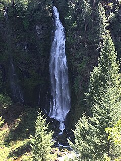
Multnomah Falls is a waterfall located on Multnomah Creek in the Columbia River Gorge, east of Troutdale, between Corbett and Dodson, Oregon, United States. The waterfall is accessible from the Historic Columbia River Highway and Interstate 84. Spanning two tiers on basalt cliffs, it is the tallest waterfall in the state of Oregon at 620 ft (189 m) in height. The Multnomah Creek Bridge, built in 1914, crosses below the falls, and is listed on the National Register of Historic Places.

The Rogue River in southwestern Oregon in the United States flows about 215 miles (346 km) in a generally westward direction from the Cascade Range to the Pacific Ocean. Known for its salmon runs, whitewater rafting, and rugged scenery, it was one of the original eight rivers named in the Wild and Scenic Rivers Act of 1968. Beginning near Crater Lake, which occupies the caldera left by the explosive volcanic eruption and collapse of Mount Mazama, the river flows through the geologically young High Cascades and the older Western Cascades, another volcanic province. Further west, the river passes through multiple exotic terranes of the more ancient Klamath Mountains. In the Kalmiopsis Wilderness section of the Rogue basin are some of the world's best examples of rocks that form the Earth's mantle. Near the mouth of the river, the only dinosaur fragments ever discovered in Oregon were found in the Otter Point Formation, along the coast of Curry County.

Oneonta Gorge is a scenic gorge located in the Columbia River Gorge area of the American state of Oregon. The U.S. Forest Service has designated it as a botanical area because of the unique aquatic and woodland plants that grow there. Exposed walls of 25-million-year-old basalt are home to a wide variety of ferns, mosses, hepatics, and lichens, many of which grow only in the Columbia River Gorge. Oneonta Gorge with its 50 species of wildflowers, flowering shrubs and trees has been described as "one of the true dramatic chasms in the state." The Oneonta Gorge Creek Bridge is listed on the National Register of Historic Places.
Barr Creek Falls, is a waterfall located in the Rogue River Canyon within the Prospect State Scenic Viewpoint in Jackson County, in the U.S. state of Oregon. The waterfall is located at the south end of Barr Creek as it plunges into the Rogue River over a carved cliff surrounded by walls of petrified volcanic ash as a consequence of the Mount Mazama eruption. The waterfall has also been called Bear Creek Falls. The waterfall gets its name from the creek which was called "Barr" for the presence of a fence that prevented cattle from straying out of the local Red Blanket Ranch and that ran adjacent to the creek.

The Anna River is a 7.1-mile-long (11.4 km) river on the Upper Peninsula of the U.S. state of Michigan. The mouth of the river is at 46°24′40″N86°38′26″W in the city of Munising on the South Bay of Grand Island Harbor on Lake Superior.

The Salmon River is a 33.5-mile (53.9 km) river in the Cascade Range in the U.S. state of Oregon that drains part of southwestern Mount Hood. The entire length of the river is a protected National Wild and Scenic River. Several portions are in protected wilderness. It is affluent to the Sandy River, a tributary of the Columbia River.

Mill Creek Falls, is a waterfall located in the Rogue River Canyon within the Prospect State Scenic Viewpoint in Jackson County, in the U.S. state of Oregon. The waterfall is located at the south end of Mill Creek as it plunges into the Rogue River over a carved cliff surrounded by walls of petrified volcanic ash consequence of Mount Mazama eruption.
The valley of the West Fork Foss River contains a fair amount of waterfalls. The river heads in a series of large lakes: Big Heart Lake, Angeline Lake, and Otter Lake- which form spectacular waterfalls as they plunge down to Delta Lake. On the valley walls downstream of Delta Lake, are found even more waterfalls.

Salt Creek Falls is a cascade and plunge waterfall on Salt Creek, a tributary of the Middle Fork Willamette River, that plunges into a gaping canyon near Willamette Pass in the Willamette National Forest, near Oakridge, Oregon. The waterfall is notable for its main drop of 286 feet (87 m) which makes it the third highest plunge waterfall in Oregon after Multnomah Falls and Watson Falls the second highest, which was re-measured in 2009 and found to be 293 feet rather than an earlier measurement of 272 feet passing Salt Creek Falls. The pool at the bottom of the waterfall is 20 metres (66 ft) deep.
Sulphide Creek is a 2.5-mile (4.0 km) glacial tributary of the Baker River in Whatcom County in the U.S. state of Washington, draining a steep and narrow canyon on the southeast flank of Mount Shuksan, inside North Cascades National Park. Although called a creek, it is river-like due to its high volume. The creek is fed by the "massive" Sulphide and Crystal glaciers above Sulphide Lake and it runs east collecting several small tributaries before flowing into the Baker River at elevation 869 feet (265 m). There are several very tall waterfalls occurring on the creek and its tributaries, the largest of which is Sulphide Creek Falls.

The Rogue River in the U.S. state of Oregon begins at Boundary Springs on the border between Klamath and Douglas counties near the northern edge of Crater Lake National Park. The Rogue River flows generally west for 215 miles (346 km) from the Cascade Range through the Rogue River – Siskiyou National Forest and the Klamath Mountains to the Pacific Ocean at Gold Beach. Communities along its course include Union Creek, Prospect, Trail, Shady Cove, Gold Hill, and Rogue River, all in Jackson County; Grants Pass, and Galice in Josephine County, and Agness, Wedderburn and Gold Beach in Curry County. Significant tributaries include the South Fork Rogue River, Elk Creek, Bear Creek, the Applegate River, and the Illinois River. Arising at 5,320 feet (1,622 m) above sea level, the river loses more than 1 mile (1.6 km) in elevation by the time it reaches the Pacific.
Upper Chush Falls is a 200-foot (61 m) waterfall on Whychus Creek, in the Cascade Range southwest of Sisters in the U.S. state of Oregon. Chush Falls, a 50-foot (15 m) waterfall, is further downstream on the same creek. Lying between Chush and Upper Chush is a third waterfall, The Cascade. These and several other falls on tributaries in the vicinity are within the Three Sisters Wilderness. The Northwest Waterfall Survey lists the fall's average flow at 40 cubic feet per second (1.1 m3/s). The highest flows occur between May and August.
Alkali Falls, is a multi-step waterfall of 6 tiers located in the east side of the Rogue–Umpqua Divide Wilderness, just west of Mount Bailey and Diamond Lake, on Oregon Route 230 in Douglas County, in the U.S. state of Oregon. It totals 510 feet fall in six drops, the Upper Alkali and tallest drop is 130 feet, making it one of the tallest cascades in Oregon.
Coquiller River Falls, is a two-tier waterfall located in the far north tip of the Rogue River – Siskiyou National Forest, just east of Port Orford, on the Oregon Coast in Coos County, in the U.S. state of Oregon. It totals 115 feet fall in two drops: the upper falls is 50 feet high and the lower tier, the tallest drop, is 65 feet. There are approximately 180 feet from the upper tier to the bottom drop of the waterfall.

Cavitt Creek Falls, is a waterfall located on the west edge of the Umpqua National Forest, outside of the town of Glide, in Douglas County, in the U.S. state of Oregon. It totals 8 feet fall in one cascade that shoots into a large swimming bowl and is the centerpiece attraction of the Cavitt Creek Falls trailhead and Recreation Site. Boulders across Cavitt Creek create two channels of water flow that make the cascade and add to a combined width of approximately 15 feet.
Winter Falls, is a waterfall located in the Silver Falls State Park at the east end of the city of Salem, in Marion County, in the U.S. state of Oregon. It is located in a privileged area on the west foothills where Mount Hood National Forest meets with the Middle Santiam Wilderness. Several prominent waterfalls are located in the Park along Trail of Ten Falls: South Falls, Lower South Falls, Lower North Falls, and Drake Falls—among others.

North Falls is a waterfall located in the Silver Falls State Park at the east end of the city of Salem, in Marion County, in the U.S. state of Oregon. It is located in a privileged area on the west foothills where Mount Hood National Forest meets with the Middle Santiam Wilderness. Several prominent waterfalls are located in the Park along Trail of Ten Falls: South Falls, Drake Falls, Lower South Falls, and Winter Falls—among others.

Fishhawk Falls, is a waterfall located along the Fishhawk Creek in Clatsop County, in the U.S. state of Oregon. It totals 72 feet fall in one wide cascade and is the centerpiece attraction of the Lee Wooden Fishhawk Falls trailhead and Recreation Site. Fishhawk Falls is located a mile from the Jewell Meadows Wildlife Area off of Highway 202 between Jewell and Astoria.

Beaver Creek Falls is a small waterfall located at the confluence of Beaver and Sweet Creeks in Lane County, in the U.S. state of Oregon. The waterfall is known for joining of the two creeks becoming one intertwined waterfall.

Butte Creek Falls, is a waterfall located on the south east of Scotts Mills, in Marion County, in the U.S. state of Oregon. It totals 78 feet fall in one wide cascade and is the centerpiece attraction of the Butte Creek Falls trailhead and Recreation Site.


