
Multnomah Falls is a waterfall located on Multnomah Creek in the Columbia River Gorge, east of Troutdale, between Corbett and Dodson, Oregon, United States. The waterfall is accessible from the Historic Columbia River Highway and Interstate 84. Spanning two tiers on basalt cliffs, it is the tallest waterfall in the state of Oregon at 620 ft (189 m) in height.
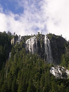
Della Falls is a waterfall in Strathcona Provincial Park on Vancouver Island and is among one of the tallest waterfalls in Canada.
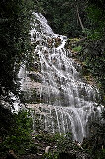
Bridal Veil Falls Provincial Park is located on the Trans-Canada Highway just east of Rosedale, British Columbia, Canada, part of the City of Chilliwack. The community of Bridal Falls is located adjacent to the falls and park was well as the interchange between the Trans-Canada and BC Highway 9 and has a variety of highway-based tourism services.
Wahkeena Falls is a 242-foot waterfall in the Columbia River Gorge in the state of Oregon.

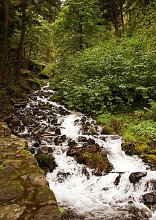
The Oneonta Gorge is a scenic gorge located in the Columbia River Gorge area of the American state of Oregon. The U.S. Forest Service has designated it as a botanical area because of the unique aquatic and woodland plants that grow there. Exposed walls of 25-million-year-old basalt are home to a wide variety of ferns, mosses, hepatics and lichens, many of which grow only in the Columbia River Gorge. Oneonta Gorge has been described as "one of the true dramatic chasms in the state. "
Bridal Veil Falls is a waterfall located on Bridal Veil Creek in the Columbia River Gorge in Multnomah County, Oregon, United States.

Horsetail Falls is a waterfall along the Columbia River Gorge in the U.S. state of Oregon.

Latourell Falls is a waterfall along the Columbia River Gorge in the U.S. state of Oregon, within Guy W. Talbot State Park.

Shepperd's Dell is a small canyon in the Columbia River Gorge in Oregon, located at 45.54833°N 122.195°W which is less than one-third mile southeast of Rooster Rock State Park.

Nairn Falls Provincial Park is a provincial park in British Columbia, Canada located on the Green River adjacent to British Columbia Highway 99 and the Canadian National Railway line just south of Pemberton and less than twenty minutes north of the resort town of Whistler. The 170 hectare park was established in 1966, shortly after the highway's opening, to protect and enhance visitor access to Nairn Falls, a double waterfall connected by a small canyon which throttles the flow of the Green River just before its accession to the lowlands of the Pemberton Valley and its confluence with the Lillooet River just above that river's estuary into Lillooet Lake.
The Black River is a 41.1-mile-long (66.1 km) river on the Upper Peninsula of the U.S. state of Michigan, flowing mostly in Gogebic County into Lake Superior at 46°40′03″N90°02′57″W. Its source at 46°18′54″N90°01′15″W is a boreal wetland on the border with Iron County, Wisconsin. The northern section of the river, 14 miles (23 km) within the boundaries of the Ottawa National Forest, was designated a National Wild and Scenic River in 1992.
Starvation Creek State Park is a state park located west of Hood River, Oregon in the Columbia River Gorge. It was named Starvation Creek because a train was stopped there by snow drifts and passengers had to dig out the train. No one starved there.
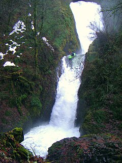
Wahclella Falls is a waterfall along Tanner Creek, a tributary of the Columbia River, in the U.S. state of Oregon. It enters the river within the Columbia River Gorge.
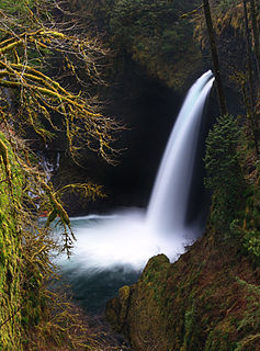
Metlako Falls is a waterfall on Eagle Creek in the Columbia River Gorge National Scenic Area in Hood River County, Oregon, United States. It is the furthest downstream of the major waterfalls on Eagle Creek. Like upstream Punch Bowl Falls, Metlako is also in the form of a punchbowl. The falls is 31 meters (101 ft) tall, though people have measured it anywhere from 30 to 46 m tall. It is the upstream limit for salmon spawning in Eagle Creek.

Coopey Falls is a waterfall on Coopey Creek in the Columbia River Gorge, on the Historic Columbia River Highway in Multnomah County, Oregon. The falls is a horsetail waterfall with a drop of 150 feet (46 m).

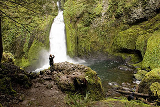
Eagle Creek is a tributary of the Columbia River in Multnomah and Hood River counties in the U.S. state of Oregon. It cuts through a narrow canyon in its 3,200 feet (980 m) descent to the Columbia River Gorge and is known for its concentration of 13 waterfalls in about 5 miles (8.0 km) distance. Eight major falls are on Eagle Creek and the East Fork Eagle Creek itself, while five are on its tributaries.

Cascade Falls Regional Park is a regional park under the administration of the Fraser Valley Regional District in the Lower Mainland region of British Columbia, Canada. The park was originally 9.5 hectares in area but was expanded to a current 22 hectares. It has picnic tables and pit toilets, with various hiking trails and a walkway leading to a viewing platform over a large waterfall 30m in vertical drop, which is 15 minutes from the park's parking lot. It is located in the McConnell Creek area northeast of Mission, which gets its name from the former name of Cascade Creek, McConnell Creek, which was named for a logger in the area called Jack McConnell. Cascade Creek's outfall is into the southeast end of Stave Lake near Davis Lake Provincial Park.

Eagle Creek Upper Falls, also called Upper Eagle Creek Falls, is a small waterfall located in Clackamas County, in the U.S. state of Oregon. The waterfall is known for a fish ladder that bypasses the waterfall to assist fish navigate the waterfall. Eagle Creek is known for being a point for fishing chinook salmon, bull trout, and steelhead trout.


