
Multnomah Falls is a waterfall located on Multnomah Creek in the Columbia River Gorge, east of Troutdale, between Corbett and Dodson, Oregon, United States. The waterfall is accessible from the Historic Columbia River Highway and Interstate 84. Spanning two tiers on basalt cliffs, it is the tallest waterfall in the state of Oregon at 620 ft (189 m) in height. The Multnomah Creek Bridge, built in 1914, crosses below the falls, and is listed on the National Register of Historic Places.

The Youngs River is a tributary of the Columbia River, approximately 27 miles (43 km) long, in northwest Oregon in the United States. It drains part of the Northern Oregon Coast Range in the extreme northwest corner of state, entering the Columbia via Youngs Bay just approximately 10 miles (16 km) from its mouth.

Oneonta Gorge is a scenic gorge located in the Columbia River Gorge area of the American state of Oregon. The U.S. Forest Service has designated it as a botanical area because of the unique aquatic and woodland plants that grow there. Exposed walls of 25-million-year-old basalt are home to a wide variety of ferns, mosses, hepatics, and lichens, many of which grow only in the Columbia River Gorge. Oneonta Gorge with its 50 species of wildflowers, flowering shrubs and trees has been described as "one of the true dramatic chasms in the state." The Oneonta Gorge Creek Bridge is listed on the National Register of Historic Places.

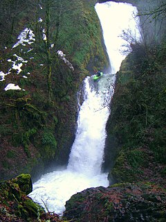
Punch Bowl Falls is a waterfall on Eagle Creek in the Columbia River Gorge National Scenic Area, Oregon, United States. Eagle Creek drains into the Columbia River, with its outlet on the Columbia River Gorge in Multnomah County.
The Bridal Veil Falls in the Columbia River Gorge in Oregon is a waterfall located on Bridal Veil Creek. It is located in Multnomah County, Oregon, United States.

Latourell Falls is a waterfall along the Columbia River Gorge in the U.S. state of Oregon, within Guy W. Talbot State Park.

Silver Falls State Park is a state park in the U.S. state of Oregon, located near Silverton, about 20 miles (32 km) east-southeast of Salem. It is the largest state park in Oregon with an area of more than 9,000 acres (36 km2), and it includes more than 24 miles (39 km) of walking trails, 14 miles (23 km) of horse trails, and a 4-mile (6.4 km) bike path. Its 8.7-mile (14.0 km) Canyon Trail/Trail of Ten Falls runs along the banks of Silver Creek and by ten waterfalls, from which the park received its name. Four of the ten falls have an amphitheater-like surrounding that allows the trail to pass behind the flow of the falls. The Silver Falls State Park Concession Building Area and the Silver Creek Youth Camp-Silver Falls State Park are separately listed on the U.S. National Register of Historic Places.

Wahclella Falls is a waterfall along Tanner Creek, a tributary of the Columbia River, Multnomah County, Oregon, United States. It enters the river within the Columbia River Gorge.

Mill Creek Falls, is a waterfall located in the Rogue River Canyon within the Prospect State Scenic Viewpoint in Jackson County, in the U.S. state of Oregon. The waterfall is located at the south end of Mill Creek as it plunges into the Rogue River over a carved cliff surrounded by walls of petrified volcanic ash consequence of Mount Mazama eruption.
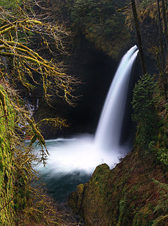
Metlako Falls is a waterfall on Eagle Creek in the Columbia River Gorge National Scenic Area in Hood River County, Oregon, United States. It is the furthest downstream of the major waterfalls on Eagle Creek. Like upstream Punch Bowl Falls, Metlako is also in the form of a punchbowl. The falls is 31 meters (101 ft) tall, though people have measured it anywhere from 30 to 46 m tall. It is the upstream limit for salmon spawning in Eagle Creek.
Eagle Creek is a tributary of the Columbia River in Multnomah and Hood River counties in the U.S. state of Oregon. It cuts through a narrow canyon in its 3,200 feet (980 m) descent to the Columbia River Gorge and is known for its concentration of 13 waterfalls in about 5 miles (8.0 km) distance. Eight major falls are on Eagle Creek and the East Fork Eagle Creek itself, while five are on its tributaries.

Salt Creek Falls is a cascade and plunge waterfall on Salt Creek, a tributary of the Middle Fork Willamette River, that plunges into a gaping canyon near Willamette Pass in the Willamette National Forest, near Oakridge, Oregon. The waterfall is notable for its main drop of 286 feet (87 m) which makes it the third highest plunge waterfall in Oregon after Multnomah Falls and Watson Falls the second highest, which was re-measured in 2009 and found to be 293 feet rather than an earlier measurement of 272 feet passing Salt Creek Falls. The pool at the bottom of the waterfall is 20 metres (66 ft) deep.

Havasu Creek is a stream in the U.S. state of Arizona associated with the Havasupai people. It is a tributary to the Colorado River, which it enters in the Grand Canyon.

The Poesten Kill is a 26.2-mile-long (42.2 km) creek in upstate New York located entirely in Rensselaer County, which flows westerly from its source at Dyken Pond in the town of Berlin to its mouth at the Hudson River in the city of Troy. It has been used historically as a source of water for local inhabitants and farmers and became even more important as a source of water power during the Industrial Revolution, during which many mills and factories sprung up along its banks.

Starvation Creek Falls, is a two tier waterfall located in the Starvation Creek State Park at the north skirt of the Columbia River Gorge, in Hood River County, in the U.S. state of Oregon. It is located in a privileged area along the Historic Columbia River Highway, where four waterfalls are located in the Starvation Creek State Park: Cabin Creek Falls, Hole In the Wall Falls, Lancaster Falls, and Starvation Creek Falls—all within 2 miles from each other.

Wah Gwin Gwin Falls, also known as Lullaby Falls, is a waterfall of Phelps Creek located in the property of the historic Columbia Gorge Hotel, in Hood River County, in the U.S. state of Oregon. The waterfall is notable for its main drop of 207 feet (63 m) that plunges through steep cascades into the Columbia River, south of the city of Hood River, Oregon.

Warren Creek Falls was a waterfall located in Starvation Creek State Park at the north skirt of the Columbia River Gorge, in Hood River County in the U.S. state of Oregon. It was located in a privileged area along the Historic Columbia River Highway, where several waterfalls are located in Starvation Creek State Park, including Cabin Creek Falls, Lancaster Falls, and Starvation Creek Falls—all within 2 miles (3 km) of each other. It is frequently referred to as the name for Hole-in-the-Wall Falls, a few yards downstream of Warren Creek.
Wahe Falls, also called Moffett Creek Falls, is an 80-foot waterfall on the Columbia River Gorge, Multnomah County, Oregon, United States. Wahe Falls is the last of several waterfalls along Moffett Creek. The mouth of the Creek is within the limits of the John B. Yeon State Scenic Corridor.

Elowah Falls, also called McCord Creek Falls, is a 213-foot waterfall on the Columbia River Gorge, Multnomah County, Oregon, United States. Elowah Falls is one of several waterfalls along McCord Creek. The Creek and the waterfall are within the limits of the John B. Yeon State Scenic Corridor.

Eagle Creek Upper Falls, also called Upper Eagle Creek Falls, is a small waterfall located in Clackamas County, in the U.S. state of Oregon. The waterfall is known for a fish ladder that bypasses the waterfall to assist fish navigate the waterfall. Eagle Creek is known for being a point for fishing chinook salmon, bull trout, and steelhead trout.
