Celilo Falls

Last updated
Celilo Falls
Wyam
Corps-engineers-archives celilo falls color.jpg
Dipnet fishing at Celilo Falls in the 1950s
USA Oregon relief location map.svg
Red pog.svg
Celilo Falls
LocationBetween Wasco County, Oregon and Klickitat County, Washington
Coordinates 45°38′58″N120°58′41″W / 45.64945°N 120.97792°W / 45.64945; -120.97792
Type Segmented steep cascade; submerged since 1957
Watercourse Columbia River

Celilo Falls (Wyam, meaning "echo of falling water" or "sound of water upon the rocks," in several native languages) was a tribal fishing area on the Columbia River, just east of the Cascade Mountains, on what is today the border between the U.S. states of Oregon and Washington. The name refers to a series of cascades and waterfalls on the river, as well as to the native settlements and trading villages that existed there in various configurations for 15,000 years. Celilo was the oldest continuously inhabited community on the North American continent until 1957, when the falls and nearby settlements were submerged by the construction of The Dalles Dam. [1] In 2019, there were calls by tribal leaders to restore the falls. [2]

Contents

Geography

Native salmon fishermen at Celilo Falls. Russell Lee, September 1941. Celilo Falls Lee 2.jpg
Native salmon fishermen at Celilo Falls. Russell Lee, September 1941.

Main waterfall

The main waterfall, known variously as Celilo Falls, The Chutes, Great Falls, or Columbia Falls, [3] consisted of three sections: a cataract, called Horseshoe Falls or Tumwater Falls; a deep eddy, the Cul-de-Sac; and the main channel. [4] These features were formed by the Columbia River's relentless push through basalt narrows on the final leg of its journey to the Pacific Ocean. Frequently more than a mile (1.6 km) in width, the river was squeezed here into a width of only 140 feet (43 m). [5] The seasonal flow of the Columbia changed the height of the falls over the course of a year. At low water the drop was about 20 feet (6.1 m). In 1839, Modeste Demers investigated the area in some detail and described not just one fall but a great many, in different channels and with different qualities. He wrote, "The number and variety [of the channels and falls] are surprising. They are not all equally deep. The falls are from 3 to 12 and 15 feet high." [3] During the spring freshet in June and July, the falls could be completely submerged. The falls were the sixth-largest by volume in the world and were among the largest in North America. [6] Average annual flow was about 190,000 ft3/sec (5,380 m3/s), and during periods of high water or flood, as much as 1,240,000 ft3/sec (35,113 m3/s) passed over the falls. [4]

Fishing sites existed along the entire length of The Narrows. Russell Lee, September 1941. Celilo Falls Lee.jpg
Fishing sites existed along the entire length of The Narrows. Russell Lee, September 1941.

The Narrows and The Dalles

Celilo Falls itself was the first in a series of cascades and rapids known collectively as The Narrows or The Dalles, stretching for about 12 miles (19 km) downstream. [7] Over that length, the river dropped 82 feet (25 m) at high water and 63 feet (19 m) at low water. [3]

The Dalles (photo from Horner, 1919) Grand Dalles of the Columbia.png
The Dalles (photo from Horner, 1919)

Three miles (4.8 km) below Celilo Falls was a stretch of rapids known variously as the Short Narrows, Ten Mile Rapids, the Little (or Upper) Dalles, or Les Petites Dalles. These rapids were about 1 mile (1.6 km) long and 250 feet (76 m) wide. Ten miles (16 km) below Celilo Falls was another stretch of rapids, this one known as the Long Narrows, Five Mile Rapids, the Big (or Lower) Dalles, Les Grandes Dalles, or Grand Dalles. This stretch of rapids was about 3 miles (4.8 km) long, and the river channel narrowed to 75 feet (23 m). Immediately downstream were the Dalles Rapids (or Wascopam to the local natives), about 1.5 miles (2.4 km) long. Here the river dropped 15 feet (4.6 m) in a tumult much commented on by early explorers. [3]

The Long Narrows and the Dalles Rapids are sometimes grouped together under names such as Grand Dalles, Les Dalles, Big Dalles, or The Dalles. One early observer, Ross Cox, noted a three-mile "succession of boiling whirlpools." [3] Explorer Charles Wilkes described it as "one of the most remarkable places upon the Columbia." He calculated that the river dropped about 50 feet (15 m) over 2 miles (3.2 km) here. During the spring freshet, the river rose as much as 62 feet (19 m), radically altering the nature of the rapids. [3] Fur trader Alexander Ross wrote, "[The water] rushes with great impetuosity; the foaming surges dash through the rocks with terrific violence; no craft, either large or small, can venture there safely. During floods, this obstruction, or ledge of rocks, is covered with water, yet the passage of the narrows is not thereby improved." [3]

History

Native Americans drying salmon, circa 1900 Indians drying salmon by James M Davis, c1900.jpg
Native Americans drying salmon, circa 1900

Fishing and trading

Our waters shall be free: free to serve the uses and purposes of their creation by a Divine Providence.

—Portland investor and civic leader Joseph Nathan Teal, at the canal's opening ceremony. [8]

Newsreel footage of native fishers at Celilo Falls in 1956, shortly before the site was submerged by The Dalles Dam
Lewis and Clark Expedition map, 1806 Clark Family Collection- Volume 4. Voorhis Journal No. 4, page 7, October 22-23, 1806.jpg
Lewis and Clark Expedition map, 1806

For 15,000 years, native peoples gathered at Wyam to fish and exchange goods. [9] They built wooden platforms out over the water and caught salmon with dipnets and long spears on poles as the fish swam up through the rapids and jumped over the falls. [10] Historically, an estimated fifteen to twenty million salmon passed through the falls every year, making it among the greatest fishing sites in North America. [11]

Celilo Falls and The Dalles were strategically located at the border between Chinookan and Sahaptian speaking peoples and served as the center of an extensive trading network across the Pacific Plateau. [12] Artifacts from the original village site at Celilo suggest that trade goods came from as far away as the Great Plains, Southwestern United States, and Alaska. [13] There are also numerous rock art drawings at the head of the falls. This demonstrates the site to not just be important for trading purposes. It acted as a melting pot for the cultures which fished and traded there. [14] When the Lewis and Clark Expedition passed through the area in 1805, the explorers found a "great emporium...where all the neighboring nations assemble," and a population density unlike anything they had seen on their journey. [15] Accordingly, historians have likened the Celilo area to the "Wall Street of the West." [16] The Wishram people lived on the north bank, while the Wasco lived on the south bank, with the most intense bargaining occurring at the Wishram village of Nix-luidix. [12] Charles Wilkes reported finding three major native fishing sites on the lower Columbia — Celilo Falls, the Big Dalles, and Cascades Rapids, with the Big Dalles being the largest. Alexander Ross described it as the "great rendezvous" of native traders, as "the great emporium or mart of the Columbia." [3] Pinnipeds such as sea lions and seals followed salmon up the Columbia as far as Celilo Falls. In 1841 George Simpson wrote "these animals ascend the Columbia in great numbers in quest of the salmon." [17]

The seasonal changes in the Columbia's flow, high in summer and low in winter, affected Celilo Falls dramatically. Lewis and Clark reached Celilo Falls in the late autumn when the water was relatively low, turning the falls into a major barrier. In contrast, when David Thompson passed Celilo Falls in July 1811, the high water obscured the falls and made his passage through the Columbia Gorge relatively easy. [18] Modeste Demers wrote about the seasonal change in 1839: "One may be astonished to learn that these chutes, so terrible at low water, are smooth and still at very high water, which does not happen every year. Then it is that, instead of fearing them, the voyageurs hasten to approach them, to light their pipes and rest." [3] More difficult was the Long Narrows, or Big Dalles, ten miles below Celilo Falls. This section of the river was impassable during high water. During the autumn low water they were passable but with unloaded boats only, and even then the passage was very dangerous. "They are never passed without dread," wrote François Blanchet in 1839. [3] Narcissa Whitman asserted in 1836 that over one hundred "white lives" had been lost at the Dalles. [19]

In the 1840s and 1850s, American pioneers began arriving in the area, traveling down the Columbia on wooden barges loaded with wagons. Many lost their lives in the violent currents near Celilo. [20] In the 1870s, the Army Corps of Engineers embarked on a plan to improve navigation on the river. In 1915, they completed the 14-mile (23 km) Celilo Canal, a portage allowing steamboats to circumvent the turbulent falls. Though the canal's opening was greeted with great enthusiasm and anticipation, the canal was scarcely used and was completely idle by 1919. [21]

Flooding by the dam

2008 sonar survey showing Celilo Falls remains intact. Celilo Sonar.jpg
2008 sonar survey showing Celilo Falls remains intact.

As more settlers arrived in the Pacific Northwest in the 1930s and 1940s, civic leaders advocated a system of hydroelectric dams on the Columbia River. They argued that the dams would improve navigation for barge traffic from interior regions to the ocean; provide a reliable source of irrigation for agricultural production; provide electricity for the World War II defense industry; and alleviate the flooding of downriver cities, as occurred in the 1948 destruction of Vanport, Oregon.

Aluminum production, shipbuilding, and nuclear production at the Hanford site contributed to a rapid increase in regional demand for electricity. By 1943, fully 96 percent of Columbia River electricity was being used for war manufacturing. [22] The volume of water at Celilo Falls made The Dalles an attractive site for a new dam in the eyes of the Corps of Engineers.

Throughout this period, native people continued to fish at Celilo, under the provisions of the 1855 Treaties signed with the Yakama Nation, [23] the Confederated Tribes of Warm Springs, [24] and the Walla Walla, Umatilla, and Cayuse, [25] which guaranteed the tribes' ancient "right of taking fish at all usual and accustomed stations." In 1947, the federal government convened Congressional hearings and concluded that the proposed dam at The Dalles would not violate tribal fishing rights under the treaties. [26] Subsequently, the government reached a monetary settlement with the affected tribes, paying $26.8 million for the loss of Celilo and other fishing sites on the Columbia. [27]

The Army Corps of Engineers commenced work on The Dalles Dam in 1952 and completed it five years later. On March 10, 1957, hundreds of observers looked on as a rising Lake Celilo rapidly silenced the falls, submerged fishing platforms, and consumed the village of Celilo, ending an age-old existence for those who lived there. A small Native American community exists today at nearby Celilo Village, on a bluff overlooking the former location of the falls.

In 2008 the Army Corps of Engineers completed a survey of the Celilo Falls site using sonar technology, in response to the 50th anniversary of the flooding of the falls. The survey revealed that the falls remain intact below the artificial lake, and that "rocky outcrops, carved basins and channels that match aerial photographs from the 1940s." [28]

Legacy

Celilo Falls retains great cultural significance for native peoples. Ted Strong of the Intertribal Fish Commission told one historian, "If you are an Indian person and you think, you can still see all the characteristics of that waterfall. If you listen, you can still hear its roar. If you inhale, the fragrances of mist and fish and water come back again." [26] In 2007, three thousand people gathered at Celilo Village to commemorate the 50-year anniversary of the inundation of the falls. [29]

In Ken Kesey's novel One Flew Over the Cuckoo's Nest, the narrator, Chief Bromden, grows up in a native village near the waterfall. In one section, he encounters the government agents sent to appraise the land and negotiate with Bromden's father, the chief of the village at the time.

Artist and architect Maya Lin is working on interpretive artwork at Celilo for the Confluence Project, scheduled for completion in 2019. [30] [31] [32]

Celilo Falls aerial.jpg
Aerial view of Lake Celilo on the Columbia River, after construction of The Dalles Dam. The former location of Celilo Falls, the Short Narrows, and the Long Narrows are noted in parentheses. (The river bends to the southwest downstream of Browns Island; the left panel is rotated so that the image fits horizontally.)

Restoration calls

Yakama and Lummi nation leaders called for a restoration of the falls in 2019, who noted that Indigenous peoples never agreed to the submergence of the falls. They cited that the river's temperature has become hotter with the reservoir each year and that there has been a large decline in salmon populations. [33] They also noted that the dam has destroyed fishing sites that were guaranteed to the tribes in treaties 150 years ago. [2] In response, Northwest RiverPartners issued a statement that the dam remains important for hydropower electricity generation for ports and businesses in the area. [33]

See also

Related Research Articles

<span class="mw-page-title-main">Columbia River</span> River in the Pacific Northwest of North America

The Columbia River is the largest river in the Pacific Northwest region of North America. The river forms in the Rocky Mountains of British Columbia, Canada. It flows northwest and then south into the U.S. state of Washington, then turns west to form most of the border between Washington and the state of Oregon before emptying into the Pacific Ocean. The river is 1,243 mi (2,000 km) long, and its largest tributary is the Snake River. Its drainage basin is roughly the size of France and extends into seven states of the United States and one Canadian province. The fourth-largest river in the United States by flow, the Columbia has the greatest flow of any river into the eastern Pacific and the 36th greatest discharge of any river in the world.

<span class="mw-page-title-main">The Dalles, Oregon</span> City in the United States

The DallesDALZ; formally the City of The Dalles and also called Dalles City, is an inland port and the largest city in Wasco County, Oregon, United States. The population was 16,010 at the 2020 census, and it is the largest city in Oregon along the Columbia River outside the Portland Metropolitan Area. The Dalles is 75 miles east of Portland, within the Columbia River Gorge National Scenic Area.

<span class="mw-page-title-main">Dallesport, Washington</span> Census-designated place in Washington, United States

Dallesport is an unincorporated community and census-designated place (CDP) in Klickitat County, Washington, United States. The population was 1,328 at the 2020 census.

<span class="mw-page-title-main">Wishram, Washington</span> Census-designated place in Washington, United States

Wishram is an unincorporated community and census-designated place (CDP) in Klickitat County, Washington, United States. The population was 366 at the 2020 census. The site of the historic Celilo Falls is nearby.

<span class="mw-page-title-main">Yakama</span> Ethnic group

The Yakama are a Native American tribe with nearly 10,851 members, based primarily in eastern Washington state.

<span class="mw-page-title-main">Columbia River Gorge</span> Canyon along the border of Oregon and Washington in the United States

The Columbia River Gorge is a canyon of the Columbia River in the Pacific Northwest of the United States. Up to 4,000 feet (1,200 m) deep, the canyon stretches for over eighty miles (130 km) as the river winds westward through the Cascade Range, forming the boundary between the state of Washington to the north and Oregon to the south. Extending roughly from the confluence of the Columbia with the Deschutes River in the east down to the eastern reaches of the Portland metropolitan area, the water gap furnishes the only navigable route through the Cascades and the only water connection between the Columbia Plateau and the Pacific Ocean. It is thus that the routes of Interstate 84, U.S. Route 30, Washington State Route 14, and railroad tracks on both sides run through the gorge.

<span class="mw-page-title-main">Cascades Rapids</span> Former area of rapids along the Columbia River, US

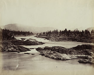
The Cascades Rapids were an area of rapids along North America's Columbia River, between the U.S. states of Washington and Oregon. Through a stretch approximately 150 yards (140 m) wide, the river dropped about 40 feet (12 m) in 2 miles (3.2 km). These rapids or cascades, along with the many cascades along the Columbia River Gorge in this area of Oregon and Washington, gave rise to the name for the surrounding mountains: the Cascade Range.

<span class="mw-page-title-main">The Dalles Dam</span> US hydroelectric dam on the Columbia River

The Dalles Lock and Dam is a concrete-gravity run-of-the-river dam spanning the Columbia River, two miles (3.2 km) east of the city of The Dalles, Oregon, United States. It joins Wasco County, Oregon, with Klickitat County, Washington, 192 miles (309 km) upriver from the mouth of the Columbia near Astoria, Oregon. The closest towns on the Washington side are Dallesport and Wishram.

<span class="mw-page-title-main">Kettle Falls</span> Historical waterfall on the Columbia River in Washington (state), United States

Kettle Falls was an ancient and important salmon fishing site on the upper reaches of the Columbia River, in what is today the U.S. state of Washington, near the Canada–US border. The falls consisted of a series of rapids and cascades where the river passed through quartzite rocks deposited by prehistoric floods on a substrate of Columbia River basalt. The river dropped nearly 50 feet (15 m), and the sound of the falls could be heard for miles away. Kettle Falls was inundated in 1940, as the waters of the reservoir Lake Roosevelt rose behind Grand Coulee Dam, permanently flooding the site.

<span class="mw-page-title-main">Celilo Village, Oregon</span> Unincorporated community in Oregon, United States

Celilo Village, Oregon is an unincorporated Native American community on the Columbia River in northeastern Wasco County in the U.S. state of Oregon. It is near Lake Celilo, the former site of Celilo Falls; it is just south of the community of Wishram, Washington, across the Columbia River.

<span class="mw-page-title-main">Oregon Railroad and Navigation Company</span> Railway company

The Oregon Railroad and Navigation Company (OR&N) was a rail and steamboat transport company that operated a rail network of 1,143 miles (1,839 km) running east from Portland, Oregon, United States, to northeastern Oregon, northeastern Washington, and northern Idaho. It operated from 1896 as a consolidation of several smaller railroads.

<span class="mw-page-title-main">Steamboats of the Columbia River</span>

Many steamboats operated on the Columbia River and its tributaries, in the Pacific Northwest region of North America, from about 1850 to 1981. Major tributaries of the Columbia that formed steamboat routes included the Willamette and Snake rivers. Navigation was impractical between the Snake River and the Canada–US border, due to several rapids, but steamboats also operated along the Wenatchee Reach of the Columbia, in northern Washington, and on the Arrow Lakes of southern British Columbia.

<span class="mw-page-title-main">Cascade Locks and Canal</span> United States historic place

The Cascade Locks and Canal was a navigation project on the Columbia River between the U.S. states of Oregon and Washington, completed in 1896. It allowed the steamboats of the Columbia River to bypass the Cascades Rapids, and thereby opened a passage from the lower parts of the river as far as The Dalles. The locks were submerged and rendered obsolete in 1938, when the Bonneville Dam was constructed, along with a new set of locks, a short way downstream.

<span class="mw-page-title-main">Celilo Canal</span> Columbia River bypass

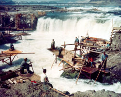
Celilo Canal was a canal in Oregon connecting two points of the Columbia River, just east of The Dalles.

<i>Colonel Wright</i> (sternwheeler)

The Colonel Wright was the first steamboat to operate on the Columbia River above The Dalles in the parts of the Oregon Country that later became the U.S. states of Oregon, Washington and Idaho. She was the first steamboat to run on the Snake River. She was named after Colonel George Wright, an army commander in the Indian Wars in the Oregon Country in the 1850s. She was generally called the Wright during her operating career.

<span class="mw-page-title-main">Tenino people</span>

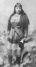
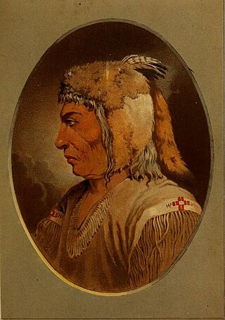
The Tenino people, commonly known today as the Warm Springs bands, are several Sahaptin Native American subtribes which historically occupied territory located in the North-Central portion of the American state of Oregon. The Tenino people included four localized subtribes — the Tygh or "Upper Deschutes" divided in Tayxɫáma, Tiɫxniɫáma and Mliɫáma, the Wyam (Wayámɫáma) (Wayámpam) or "Lower Deschutes", also known as "Celilo Indians", the Dalles Tenino or "Tinainu (Tinaynuɫáma)", also known as "Tenino proper"; and the Dock-Spus (Tukspush) (Takspasɫáma) or "John Day."

<i>Relief</i> (1906 sternwheeler)

Relief was a stern-wheel steamboat that operated on the Columbia and Willamette rivers and their tributaries from 1906 to 1931. Relief had been originally built in 1902, on the Columbia at Blalock, Oregon, in Gilliam County, and launched and operated as Columbia, a much smaller vessel. Relief was used primarily as a freight carrier, first for about ten years in the Inland Empire region of Oregon and Washington, hauling wheat and fruit, and after that was operated on the lower Columbia river.

The Celilo Fish Committee is a committee formed by representatives from the Yakama Nation of Washington.

<span class="mw-page-title-main">Skinpah</span> Indigenous people of America

The Skinpah were a Sahaptin-speaking people of the Tenino dialect living along the northern bank of the Columbia River in what is now south-central Washington. They were first recorded as the E-nee-shers in 1805 by Lewis and Clark. Their village, Sk'in, was located adjacent to Celilo Falls in modern day Klickitat County.

References

  1. Dietrich, William (1995). Northwest Passage: The Great Columbia River. Seattle, WA: University of Washington Press. p. 52. ISBN   0-671-79650-X.
  2. 1 2 "Pacific Northwest tribes: Remove Columbia River dams". AP NEWS. 2021-04-20. Retrieved 2023-01-06.
  3. 1 2 3 4 5 6 7 8 9 10 Gibson, James R. (1997). The Lifeline of the Oregon Country: The Fraser-Columbia Brigade System, 1811-47 . University of British Columbia (UBC) Press. pp.  125–128. ISBN   0-7748-0643-5.
  4. 1 2 "World Waterfall database". Archived from the original on 2006-11-28. Retrieved 2008-02-01.
  5. Dietrich, William (1995). Northwest Passage: The Great Columbia River. Seattle, WA: University of Washington Press. p. 80. ISBN   0-671-79650-X.
  6. "World Waterfall Database". Archived from the original on 2007-09-27.
  7. "The Dalles (historical)". Geographic Names Information System . United States Geological Survey, United States Department of the Interior.
  8. J. B. Tyrell, ed., David Thompson: Narrative of his Explorations in Western America, 1784-1812 (Toronto, 1916, 496-97; "Address of Joseph Nathan Teal), The Dalles-Celilo Celebration, Big Eddy, Oregon (May 5, 1915," Oregon Historical quarterly, 16 (Fall 1916), 107-8. (As quoted in "The Columbia River's fate in the twentieth century". Archived from the original on 2016-01-10. Retrieved 2007-04-16.)
  9. Barber, Katrine; Ed. William G. Robbins (2001). Narrative Fractures and Fractured Narratives: Celilo Falls in the Columbia Gorge Discovery Center and the Yakama Nation Cultural Heritage Center. Corvallis, Oregon: Oregon State University Press.{{cite book}}: |work= ignored (help)
  10. Dietrich, William (1995). Northwest Passage: The Great Columbia River. Seattle, WA: University of Washington Press. p. 154. ISBN   0-671-79650-X.
  11. Rohrbacher, George (January 2006). "Talk of the Past: The salmon fisheries of Celilo Falls". Common-Place. Archived from the original on 2007-11-11. Retrieved 2008-02-01.
  12. 1 2 Ronda, James P. (1984). Lewis & Clark among the Indians . Lincoln, Nebraska: University of Nebraska Press. ISBN   0-8032-3870-3 . Retrieved 2008-02-01.{{cite book}}: |work= ignored (help)[ dead link ]
  13. Center for Columbia River History. "Oregon's Oldest Town: 11,000 Years of Occupation". Archived from the original on 2008-02-15. Retrieved 2008-02-01.
  14. Snow, Dean R. (2010). Archaeology of Native North America. Boston: Prentice Hall. ISBN   978-0-13-615686-4.
  15. Cressman, L.S.; et al. (1960). "Cultural Sequences at the Dalles, Oregon: A Contribution to Pacific Northwest Prehistory". Transactions of the American Philosophical Society. 50 (10). American Philosophical Society: 1–108. doi:10.2307/1005853. hdl: 2027/mdp.39076005656769 . JSTOR   1005853. Archived from the original on 2019-09-24. Retrieved 2019-09-24.
  16. Alpert, Emily (2006-07-10). "Remembering Celilo Falls". The Dalles Chronicle. Archived from the original on 2006-10-08. Retrieved 2008-02-01.
  17. Mackie, Richard Somerset (1997). Trading Beyond the Mountains: The British Fur Trade on the Pacific 1793-1843. Vancouver: University of British Columbia (UBC) Press. pp. 191–192. ISBN   0-7748-0613-3. online at MacKie, Richard (1997). Trading Beyond the Mountains: The British Fur Trade on the Pacific, 1793-1843. UBC Press. ISBN   9780774806138. Archived from the original on 2016-04-26. Retrieved 2016-09-23.
  18. Meinig, D.W. (1995) [1968]. The Great Columbia Plain (Weyerhaeuser Environmental Classic ed.). University of Washington Press. pp. 37–38, 50. ISBN   0-295-97485-0.
  19. The Lifeline of the Oregon Country, p. 42
  20. "Waiilatpu Mission Resource Education Guide". Whitman Mission National Historic Site. 2004-11-14. Archived from the original (DOC) on 2008-02-28. Retrieved 2008-02-01.
  21. Dietrich, William (1995). Northwest Passage: The Great Columbia River. Seattle, WA: University of Washington Press. p. 204. ISBN   0-671-79650-X.
  22. Dietrich, William (1995). Northwest Passage: The Great Columbia River. Seattle, WA: University of Washington Press. p. 284. ISBN   0-671-79650-X.
  23. "Treaty with the Yakama, 1855". Archived from the original on 2008-02-09. Retrieved 2008-02-01.
  24. "Treaty of Wasco, Columbia River, Oregon Territory with the Taih, Wyam, Tenino, & Dock-Spus Bands of the Walla-Walla, and the Dalles, Ki-Gal-Twal-La, and the Dog River Bands of the Wasco". Archived from the original on 2007-12-19. Retrieved 2008-02-01.
  25. "Treaty with the Walla Walla, Cayuse and Umatilla, 1855". Archived from the original on 2008-02-26. Retrieved 2008-02-01.
  26. 1 2 Dietrich, William (1995). Northwest Passage: The Great Columbia River. Seattle, WA: University of Washington Press. p. 378. ISBN   0-671-79650-X.
  27. Dietrich, William (1995). Northwest Passage: The Great Columbia River. Seattle, WA: University of Washington Press. p. 376. ISBN   0-671-79650-X.
  28. Rojas-Burke, Joe (November 28, 2008). "Sonar shows Celilo Falls are intact". The Oregonian . Archived from the original on 2008-12-01. Retrieved 2008-11-28.
  29. Modie, Jonathan. "The Celilo Legacy commemoration brought together the tribes of the lower Columbia River and others to remember Celilo Falls, bringing a mix of sadness and nostalgia". Wana Chinook Tymoo. Archived from the original on 2008-05-15. Retrieved 2008-02-01.
  30. "Confluence Project: Celilo Park". Archived from the original on January 26, 2008. Retrieved 2008-02-01.
  31. "Celilo Park". Confluence Project. Archived from the original on 2014-09-11. Retrieved 2014-09-08.
  32. "FY2016-17 Competitive Process Special Appropriations Grant Awardee: CONFLUENCE Grant Project: CONFLUENCE PROJECT AT CELILO PARK". Archived from the original on 2018-03-03. Retrieved 2018-03-03.
  33. 1 2 "Northwest Tribes Call For Removal Of Lower Columbia River Dams". opb. Retrieved 2023-01-06.