
The Cascades Rapids were an area of rapids along North America's Columbia River, between the U.S. states of Washington and Oregon. Through a stretch approximately 150 yards (140 m) wide, the river dropped about 40 feet (12 m) in 2 miles (3.2 km). These rapids or cascades, along with the many cascades along the Columbia River Gorge in this area of Oregon and Washington, gave rise to the name for the surrounding mountains: the Cascade Range.

Celilo Falls was a tribal fishing area on the Columbia River, just east of the Cascade Mountains, on what is today the border between the U.S. states of Oregon and Washington. The name refers to a series of cascades and waterfalls on the river, as well as to the native settlements and trading villages that existed there in various configurations for 15,000 years. Celilo was the oldest continuously inhabited community on the North American continent until 1957, when the falls and nearby settlements were submerged by the construction of The Dalles Dam. In 2019, there were calls by tribal leaders to restore the falls.

The Oregon Railroad and Navigation Company (OR&N) was a railroad that operated a rail network of 1,143 miles (1,839 km) running east from Portland, Oregon, United States, to northeastern Oregon, northeastern Washington, and northern Idaho. It operated from 1896 as a consolidation of several smaller railroads.

The Oregon Steam Navigation Company (O.S.N.) was an American company incorporated in 1860 in Washington with partners J. S. Ruckle, Henry Olmstead, and J. O. Van Bergen. It was incorporated in Washington because of a lack of corporate laws in Oregon, though it paid Oregon taxes.

Many steamboats operated on the Columbia River and its tributaries, in the Pacific Northwest region of North America, from about 1850 to 1981. Major tributaries of the Columbia that formed steamboat routes included the Willamette and Snake rivers. Navigation was impractical between the Snake River and the Canada–US border, due to several rapids, but steamboats also operated along the Wenatchee Reach of the Columbia, in northern Washington, and on the Arrow Lakes of southern British Columbia.
The Willamette River flows northwards down the Willamette Valley until it meets the Columbia River at a point 101 miles from the Pacific Ocean, in the U.S. state of Oregon.

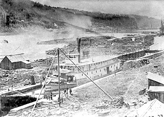
The Cascade Locks and Canal was a navigation project on the Columbia River between the U.S. states of Oregon and Washington, completed in 1896. It allowed the steamboats of the Columbia River to bypass the Cascades Rapids, and thereby opened a passage from the lower parts of the river as far as The Dalles. The locks were submerged and rendered obsolete in 1938, when the Bonneville Dam was constructed, along with a new set of locks, a short way downstream.

The steamboat Hassalo operated from 1880 to 1898 on the Columbia River and Puget Sound. Hassalo became famous for running the Cascades of the Columbia on May 26, 1888 at a speed approaching 60 miles (97 km) an hour. This vessel should not be confused with other steamboats with the same or a similar name, including Hassalo (1899) and Hassaloe (1857).

R. R. Thompson was a large sternwheel steamboat designed in the classic Columbia River style. She was named after Robert R. Thompson, one of the shareholders of the Oregon Steam Navigation Company, the firm that built the vessel.
The Colonel Wright was the first steamboat to operate on the Columbia River above The Dalles in the parts of the Oregon Country that later became the U.S. states of Oregon, Washington and Idaho. She was the first steamboat to run on the Snake River. She was named after Colonel George Wright, an army commander in the Indian Wars in the Oregon Country in the 1850s. She was generally called the Wright during her operating career.

The sidewheeler Idaho was a steamboat that ran on the Columbia River and Puget Sound from 1860 to 1898. There is some confusion as to the origins of the name; many historians have proposed it is the inspiration for the name of the State of Idaho. Considerable doubt has been cast on this due to the fact that it is unclear if the boat was named before or after the idea of 'Idaho' as a territory name was proposed. John Ruckel also allegedly stated he had named the boat after a Native American term meaning 'Gem of the Mountains' he got from a mining friend from what is now Colorado territory. This steamer should not be confused with the many other vessels of the same name, including the sternwheeler Idaho built in 1903 for service on Lake Coeur d'Alene and the steamship Idaho of the Pacific Coast Steamship Line which sank near Port Townsend, Washington.

Nez Perce Chief was a steamboat that operated on the upper Columbia River, in Washington, U.S., specifically the stretch of the river that began above the Celilo Falls. Her engines came from the Carrie Ladd, an important earlier sternwheeler. Nez Perce Chief also ran up the Snake River to Lewiston, Idaho, a distance of 141 miles from the mouth of the Snake River near Wallula, Wash. Terr.

Charles R. Spencer was a steamboat built in 1901 to run on the Willamette and Columbia rivers from Portland, to The Dalles, Oregon. This vessel was described as an "elegant passenger boat". After 1911 this vessel was rebuilt and renamed Monarch.

The Portland District is one of the five districts within the Northwestern Division of the United States Army Corps of Engineers. The Portland District is made up of some 1,100 civilian and 6 military personnel.

The Oregon Pony was the first steam locomotive to be built on the Pacific Coast and the first to be used in the Oregon Territory. The locomotive, a geared steam 5' gauge locomotive with 9"X18" cylinders and 34" drivers, was used in the early 1860s to portage steamboat passengers and goods past the Cascades Rapids, a dangerous stretch of the Columbia River now drowned by the Bonneville Dam. Steamboats provided transportation on the Columbia between Portland, Oregon and mining areas in Idaho and the Columbia Plateau. Portage was also necessary at other navigation obstructions, including Celilo Falls.

The Oregon Portage Railroad was the first railroad in the U.S. state of Oregon. It originally ran for 4.5 miles (7.2 km), with an accompanying 7 miles (11 km) of telegraph line, and was later extended to a length of 15 miles (24 km). The railroad was located on the south bank of the Cascades canal of the Columbia River. It ran from Tanner Creek to the Cascade Locks, which were under construction in the later years of the railroad's operation. Although the Oregon Portage was the first railroad in Oregon, it was not the first along the Columbia River. Francis A. Chenoweth operated a rail line on the river's north bank in present-day Washington in 1851.

Teaser was a steamboat which ran on the Columbia River and Puget Sound from 1874 to 1880.

Harvest Queen was the name of two stern-wheel steamboat built and operated in Oregon. Both vessels were well known in their day and had reputations for speed, power, and efficiency.The first Harvest Queen, widely considered one of the finest steamers of its day, was constructed at Celilo, Oregon, which was then separated from the other portions of the navigable Columbia River by two stretches of difficult to pass rapids.

Regulator was a sternwheel-driven steamboat built in 1891 which operated on the Columbia River until 1906, when it was destroyed by explosion which killed two of its crew, while on the ways undergoing an overhaul at St. Johns, Oregon.

Relief was a stern-wheel steamboat that operated on the Columbia and Willamette rivers and their tributaries from 1906 to 1931. Relief had been originally built in 1902, on the Columbia at Blalock, Oregon, in Gilliam County, and launched and operated as Columbia, a much smaller vessel. Relief was used primarily as a freight carrier, first for about ten years in the Inland Empire region of Oregon and Washington, hauling wheat and fruit, and after that was operated on the lower Columbia river.
